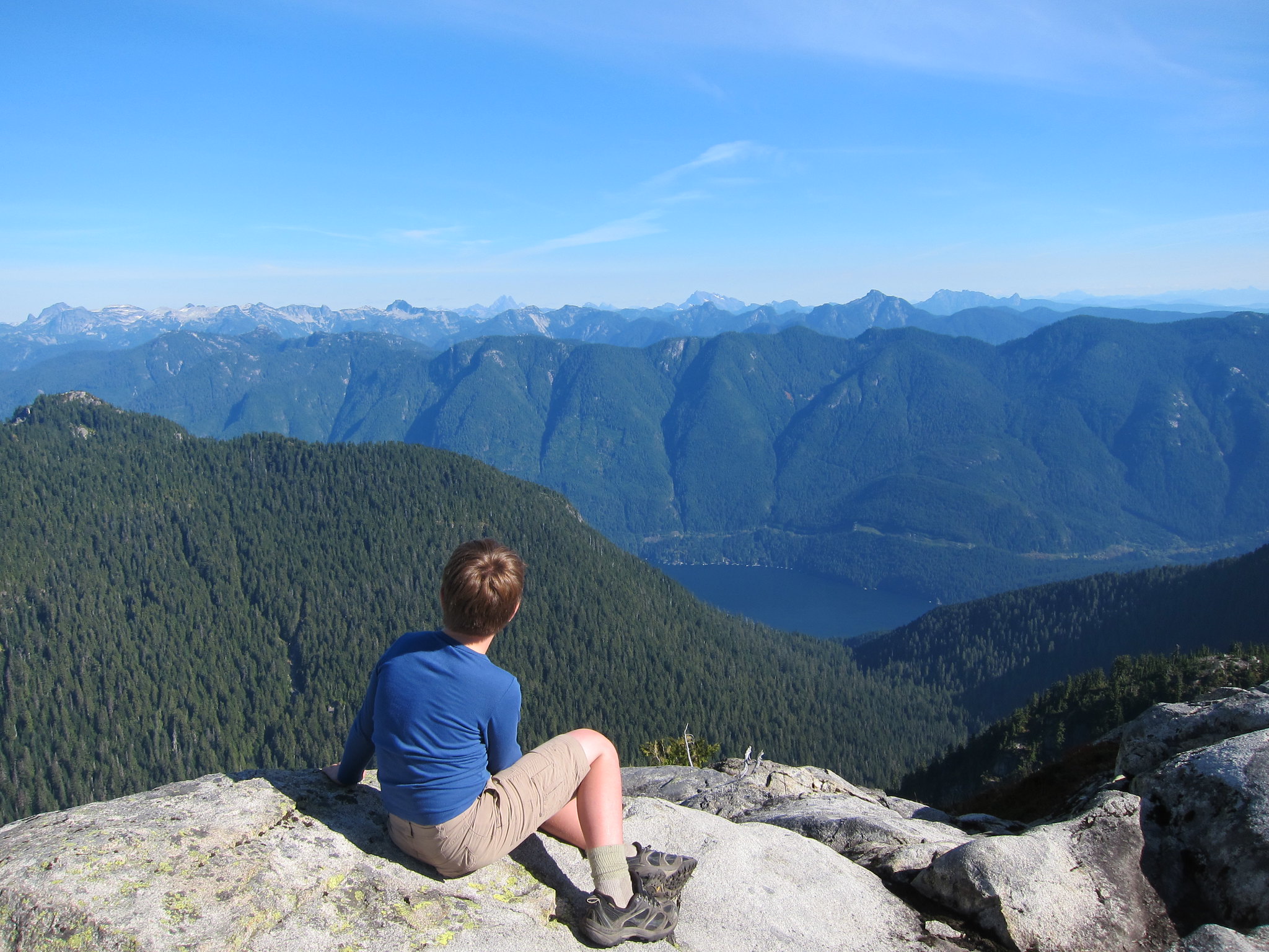
1. NEW BAGS: Added Crown N1/Godmother (CN1), which has a height of 1408m, and a prominence of 158m. It's located at the west end of the ridge the ends to the NE at Mt Perrault; access is gained from the Hanes Valley Trail. Also Enchantment Peak (ENC) ((1444m)(P:114)), which is approached from the small unnamed lake just below and to the north of the Lions. We're eyeing some within-criteria peaks between CRO and PER, as well as the distant back-door bags of Bivouac and Eldee, but these are likely horrible and dangerous.
2. GROUP BAGS: we hope to run a few "guided tour" Flash Events throughout the summer. The remote and rewarding playground of Mt Capilano will be a likely destination.
3. GIFT BAGS: earn a star bag for doing an hour or so of trail maintenance (through trail flagging, sawing of limbs and suckers, pulling of ivy and holly, and other trail maintenance) during a bag.
4. GEOCACHE BAGS: earn a star bag for hiding (and then registering and being approved) (at Geocaching.com) a geocache on the summit or route.
WHAT: See how many North Shore peaks you can run up and bag in a summer. All but the island mountains qualify as munros (in excess of 3000 feet) under the Scottish peak-bagging system.
DATES:
Mainland peaks: June 23, 2013 to October 24, 2013 at 6:30pm
Howe Sound island peaks and Spring Bag front-row peaks (ONLY): April 1, 2013 to October 24, 2013 at 6:30pm
WHERE: non-technical or less-technical (Class 3 or easier) North Shore mountains (listed below). The peak must have its own name AND it must have a prominence of at least 50 metres (i.e. to climb to the next peak one must first descend at least 50 metres).
RESULTS: Post a comment setting out your mountainous conquests (or email "David Crerar" via the CFA Message email service on this site (see left column)), with the dates, and I will post ongoing standings. Please also feel free to post your trip reports in your CFA blog (log in and go to www.clubfatass.com/node/add/bog).
YOUR STORIES: CFA and your fellow Baggers love to hear about your Bagger Adventures. To share your stories, we recommend you blog about them in your CFA member blog. Log in, then go here to get started. You can read about the 2012 adventures posted so far here.
PHOTOS: Please post your photos, too. Add to the CFA Flickr Pool (instructions here. It's easy!), tag your photos: ClubFatAss ClubFatAssEvents ClubFatAssEvents2013 BaggerChallenge2013 BaggerChallenge (with a space separating each tag on the flickr template)
2013 Photos
Photo Archives
STAR BAGS: certain extraordinary methods of bagging will earn the bagger a coveted double-star after the peak, which stars will count as tie-breakers in totals. There are three kinds of star-bags, all of equal weight:
a. WATERBAGS: An ascent up a single peak linking sea level to summit counts as a waterbag. Only one peak per sea level ascent. e.g.: Dip toe in ocean at Ambleside Beach. Run up Capilano Trails and Nancy Greene Way and Grouse Grind. Summit Grouse, Goat, and Crown = 1 waterbag, not three. So long as culmulative height of peak is accomplished in single trip, a star is earned.
b. TRUE BAGS: as the true peaks of Crown and Gotha are semi-exposed, and there is a false summit very close, attaining the false peak will get you the point, and attaining the true peak will be starred.
c. GIFT BAGS: during a bag, doing an hour or so of trail maintenance (through trail flagging, sawing of limbs and suckers, pulling of ivy and holly, and other trail maintenance) will be starred.
d. GEOCACHE BAGS: during a bag, hiding (and then registering)(at Geocaching.com) a geocache on the summit or route.
SPRING BAGS:in addition to the Howe Sound Island peaks, we've opened up the "front row" of more easily-accessible peaks to the April starting date, for anyone who wants to try a snowshoe bag. ONLY TRY IN CLEAR WEATHER and ALWAYS CHECK THE AVALANCHE REPORTS and BRING THE PROPER EQUIPMENT and BE CAUTIOUS!: BLA, HOL, STR, GRO, DAM, FRO, SLY, LYN, SEY, SUI, DEP (NOT GOA, which has a nasty sheer drop which has claimed several lives in the winter).
WINNING TIE-BREAKER MECHANISM: In the case of a tie for first place:
1. the bagger with the most starbags (i.e. 1. water bags (i.e. peaks ascended from sea level to peak: see below) 2. true bags (i.e. true summits of GOT and CRO), 3. gift bags (i.e. trail work)) will win;
2. if still a tie, the bagger with the most unique bags (i.e. peaks that no one else visited) will win;
3. if still a tie, the bagger with the most write-ups and comments posted on the CFA Flickr website will win;
4. if still a tie, the bagger with the most photos posted on the CFA Flickr website will win;
5. if still a tie, the bagger with the most obscure/difficult bags (at the completely arbitrary discretion of the host) will win.
PRIZES: The winner will be the proud bearer of the CFA Bagger Munro Quaich cup for the year: the appropriate cup from which to drink a winter whisky and contemplate how awesome you are. There will be an auxiliary prize for the person who draws the most other people into the cult of peak-bagging. For other prizes, see below.
BAGGERS' BANQUET: To cap off the bagging season, we will either have a get-together at a pub, or else a barbeque for all bagger participants and their significant others. The Bagger Quaich will be awarded.
Date: Friday, October 25, 2013. 6pm - 10pm.
Place: t.b.a.
NO SANDBAGGING: all claims to bagging a peak must be submitted as promptly as possible (in most cases, within 3 days) of the actual climb. Climbs of more than two weeks old will be stale-dated for baggers already in the contest. Old bags by new baggers will be considered on a case-by-case fairness basis at the sole discretion of the administrator: late bags by new baggers late in the season will likely not be counted.
ARCHIVES
2012 Munro Quaich: Bill Maurer: 57 (i.e. ALL) peaks
2012 Pippa Quaich: Carolyn King: 21 peaks
2012 Harry Quaich: Harry Crerar: 15 peaks
2012 Tundra Quaich: Tundra the Ultra Dog: 18 peaks
2012 Twisted Quaich: Team Dagg and Team Healey-Thorpe
ENTRY: There is no fee and you don't need to be a member of Club Fat Ass to participate in a Flash event, however whining is not allowed. That being said, many of the peaks listed should only be attempted by those with the experience and fitness level of a typical Club Fat Ass member (i.e. ample mountain running experience over long distances).
IMPORTANT SAFETY CONSIDERATIONS: All of these adventures are potentially dangerous.
You are responsible for your own well being and safety and should be self sufficient.
Here are two useful lists of "MUST HAVE" survival items that all participants should carry:
Mountains marked with a !!! are scramble ascents or otherwise exposed or otherwise remote and undeveloped and should only be attempted by experienced climbers wearing helmets, etc. Don't try these routes in anything but perfect weather.
Use great caution when rocks are wet -- slipping is the cause of most accidents on North Shore mountains.
Always run/hike with a buddy.
CFA reserves the right to remove anyone from the Challenge for doing reckless, dangerous, destructive, or foolish actions.
PARTICIPATE AT YOUR OWN RISK: YOU ARE WAIVING LEGAL ACTION: By participating in this event you agree to be wholly responsible for your own well-being and agree not to sue anyone associated with this event or Club Fat Ass or any person in relation to this activity. By participating in this event you agree to the terms of the Release of All Claims.
THE 59 NORTH SHORE PEAKS (ranges from west to east)
Altitude listed first, in brackets (metres)
# = Top-12 highest peak
P= Prominence (distance one must first descend before climbing next peak)
[[[ = NOT AN OFFICIAL PEAK in the Bagger Challenge, due to real exposure. Should only be attempted by experienced and competent alpinists. Attaining one of these peaks will nonetheless count as a bagger point.]]]
Peak notes (in round brackets at end)
peaks in italics indicate those baggable from April 1st.
for greater certainty peak ("pk") location among several possible summits (North,South, East, West)
*** as the true peaks are semi-exposed, and there is a false summit very close, attaining the false peak will get you the point, and attaining the true peak will be starred and count as a starbag (i.e. a tie-breaker).
e.g. the proper peak of Crown is a hair-raising wedge of rock with an impressive drop on 3/4 sides; attaining the (unscary) platform just below this true summit will get you a point).
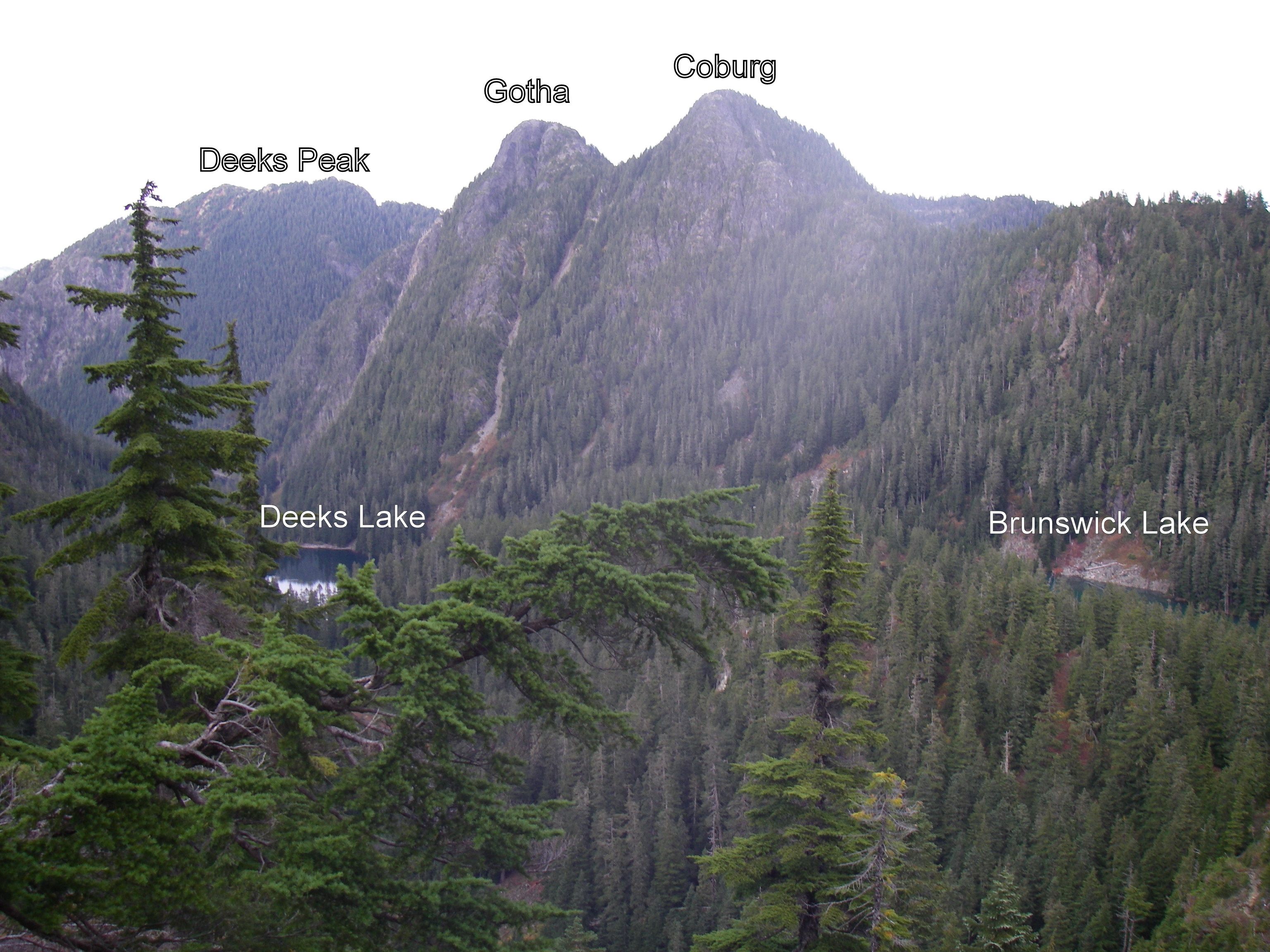
e.g.2 the proper peak of Gotha is the south peak, which is a semi-hair-raising traverse above a semi-sheer drop into Deaks Lakes way below; attaining the northern peak, with nearly identical height, will get you a point.
Resources and hyperlinks
103 = Bryceland & Macaree, 103 Hikes in Southwest British Columbia
MG = Matt Gunn, Scrambles in Southwest British Columbia
DH = Dawn Hanna, Best Hikes and Walks of Southwestern British Columbia
12= trip reports and maps
AB= peak photos
Note: the links to trip reports won't work unless your page is set to "50 comments per page" (the default setting)
Difficulty and Quality Rating {purple; in fancy brackets}
Difficulty: Hard; medium; easy
K = best hikes for kids
!!! = Dangerous: exposed or real risk of falling rock
!!!!!!!!! = Very dangerous; experienced mountaineers only
&& = trail at times faint or nonexistent; need route-finding skills
Quality: 1-5, with 1 being the best and 5 the worst
For a guided tour of the Bagger Peaks on Google Earth please click download the file attached below and open with Google Earth (and try the 3D flight simulator option under "tools"!)
For a full size Bagger map click on the image below:
Map by David Crerar; kindly and capably updated by Richard Macdonald
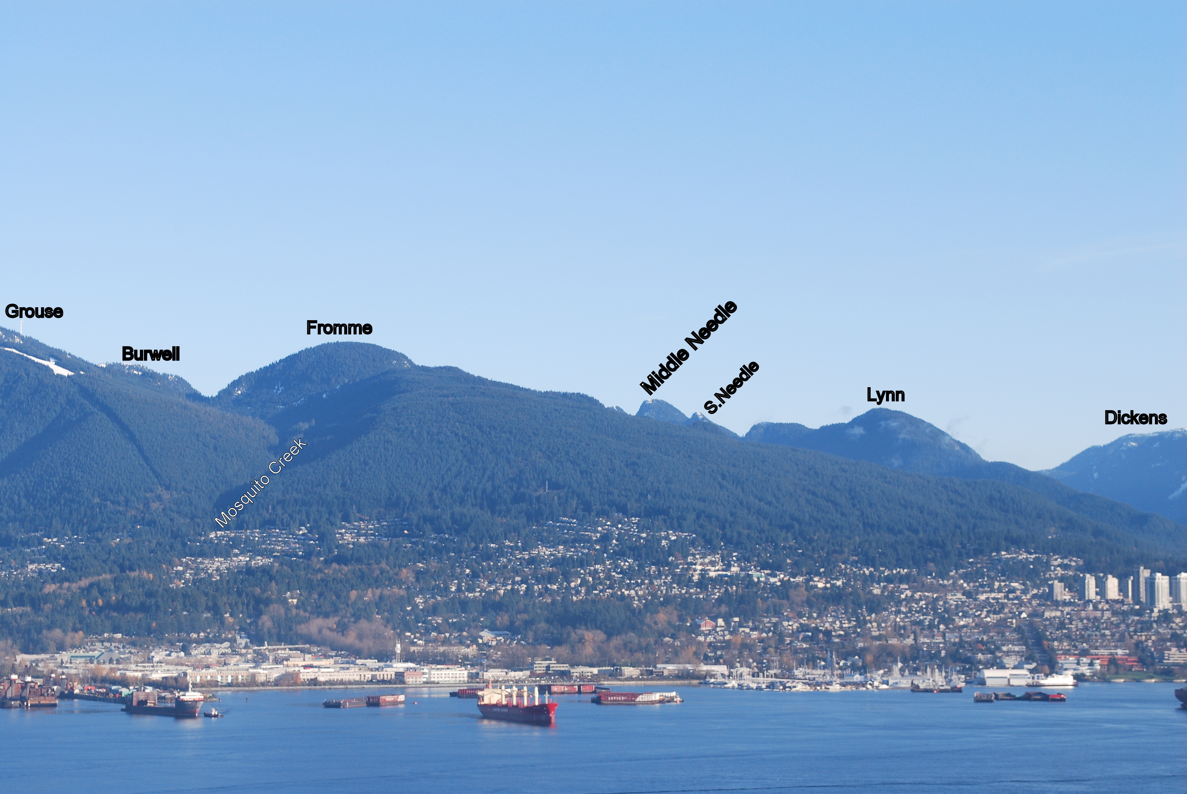
August the 11th would work for me, no preference on destination, Mr Stetson says why not run in along Lynn Valley for extra KM's and then head to Coliseum and Burwell.
Submitted by David Crerar on 29 July, 2013 - 09:16.
Off the HSCT, there is a obvious and useful side-trail just to the north of the signpost marking "St. Mark's Summit" (which the viewpoint is of course not), leading to the true summit of St. Mark's. The two-minute side-trail wends its way around and behind the summit knoll and then up to the peak: a woody bump marked by a stumped tree. Apart from taking you to the peak, it gives some nice backdoor view of Enchantment, Wizard, and Magic.
Submitted by David Crerar on 28 July, 2013 - 22:39.
Enchantment Peak is worth a visit, especially to those who blanch at climbing the West Lion and have an hour to spare in that section of the HSCT. Not an easy side-trip but not a difficult one.
Access is via the small cirque lake just NE of the Lions (there may be a safe way to approach it from the N, from the nasty scree slope on the HSCT, via Enchantment Lake). From the small unnamed lake, do not be tempted to cut straight up to the inviting western ramp heading up Enchantment. Instead, descend, to the NE, before cutting over N to a boulder field (there is a sweet and painless route, but your route may involve bushwhacking). Across the boulder field and ascend via a fallen tree and a modest creek bed. Then mild bushwhacking NE to the rocky patio at the base of Enchantment, leading to the aforementioned ramp straight up to the peak, past a few small tarns. Unusual views of the Lions (Including a twin waterfall coming off two ice fields at the base of East Lion) and a clear view to Sky Pilot and the Black Tusk make this a worthwhile diversion. Be cautious of the sheer cliff to the north: a long and unpleasant tumble into Enchantment Lake.
Do not be tempted venture south to Wizard: The Wonderful Wizard and the Magically Endless Ridge is a book not worth reading. And the only likely magic about Magic, to the south, is the joy of making it magically disappear from your to-do bagging list.
The 2013 Fannin multi-leg triathlon (olympic distance) was held today in dry conditions and warm water temperatures.
At the absurdly late hour of 10 am, this participant cycled off the start line at the LSCR gazebo on his heavy, fat-tired mtn bike, north along the Seymour Valley trail, on the first 11 km bike leg.
He crossed the new & awesome Bear Island bridge, and stashed the bike in the woods upon regaining the eastern logging road.
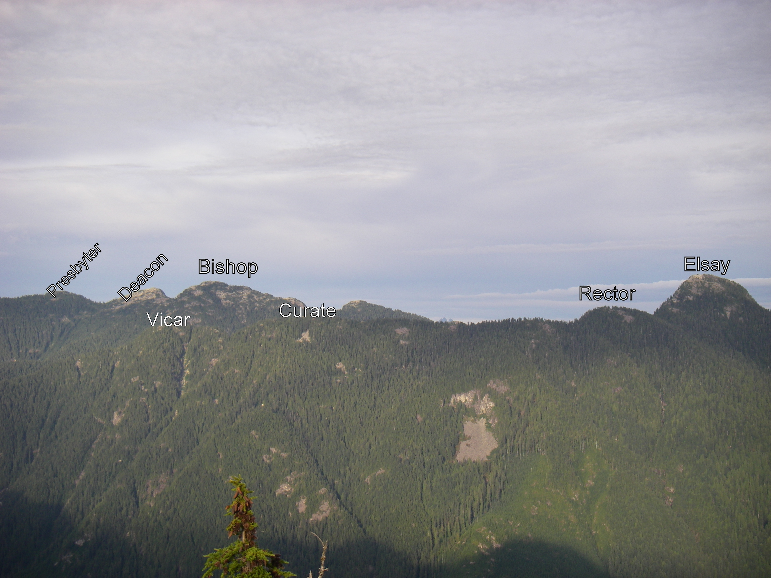
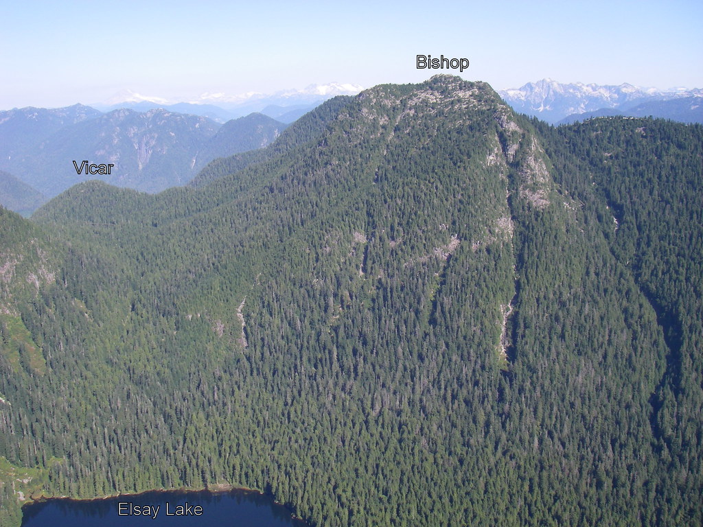
The second leg included running/hiking up the Vicar Lakes trail, quick stop for food at the big-lake aid station, regaining the Mt. Bishop trail and continuing east & up along it until reaching the alpine level meadows.
The third leg comprised of a south-east scramble up to the peak of Mt. Bishop, back down to the col, a north-east scramble up to the peak of Mt. Deacon, down & north to another col, and a final northern scramble up to the peak of Mt. Presbyter.
Refueling again at the aid station on top of Presbyter, one could only look in envy at a sparkling Fanin lake way down below, and Mt. Dickens (of bagger legends fame) towering north above it.
The fourth leg saw a southbound down scramble, trying to maintain the 1370 m countour line until back at Bishop meadows, and back down to Vicar lakes.
Transitioning to the swim leg at Vicar was shockingly fast, unlike the swim itself (length of the big lake, return) - The water were just too good to leave.
Another refueling, transition back to running shoes & pack, and downhill technical running/jumping/multi-rope-evading dash down Vicar Lakes trail to the logging road.
Final leg: un-stash bike, put on helmet, and ride back the 11 km along the Seymour Valley trail to the finish line at the Gazebo.
Final two thoughts: Apart from the 2 bike legs, the crowd support for all other legs of this triathlon was disapointingly yet awesomely completely non-existent; and next year, this participant may try the half-ironman version of this triathlon, which shifts the swim to Fannin lake, and extends the scrambling to Mt. Dickens.
On Thursday afternoon I set out from Cypress Bowl and conquored St. Mark's and Unnecessary Mountain. My trip reads pretty much like Bill's below, so I'll spare you the details. Pretty much as soon as I turned around to head back to Cypress, my stomach decided to go south on me, so the trudge to the car was a sucky, painful, doubled over slog. I told myself that the next day I was going to the beach instead of the mountains.
A good night's sleep had erased any lingering thought of lounging on the beach all day and on Friday morning I headed out to Lynn Headwaters to have a go at Coliseum Mountain and Mount Burwell. Once you get to Norvan Falls and hang a left, the uphill slog commences. That first climb is a beast. Once over that initial obstacle, the trail cuts left and there's a few runnable sections through boggy bits, meadows and across a couple little creeks. The trail continues up, up and away until a couple of near vertical climbs spit you out on the rocky alpine area. A little farther along is the Coliseum summit. It was a bluebird day with crazy 360° views. Then it was onward to Burwell. Once past Coliseum it's pretty much all rocky, alpine terrain. I messed around quite a bit through here, climbing things and generally taking the long way around. I stopped at a beautiful, clear blue, freezing cold pool and contemplated going in for a dip but just soaked my feet for a spell instead. At the summit of Burwell, the views again were spectacular. The next peak to the north is the menacing looking Cathedral Mountain with Palisade Lake far down in the valley below. I sat and ate some almonds whilst hanging out with the ravens and the horse flies before retracing my steps and heading for home. Total time, including all the mucking around, was about 7.5 hours.
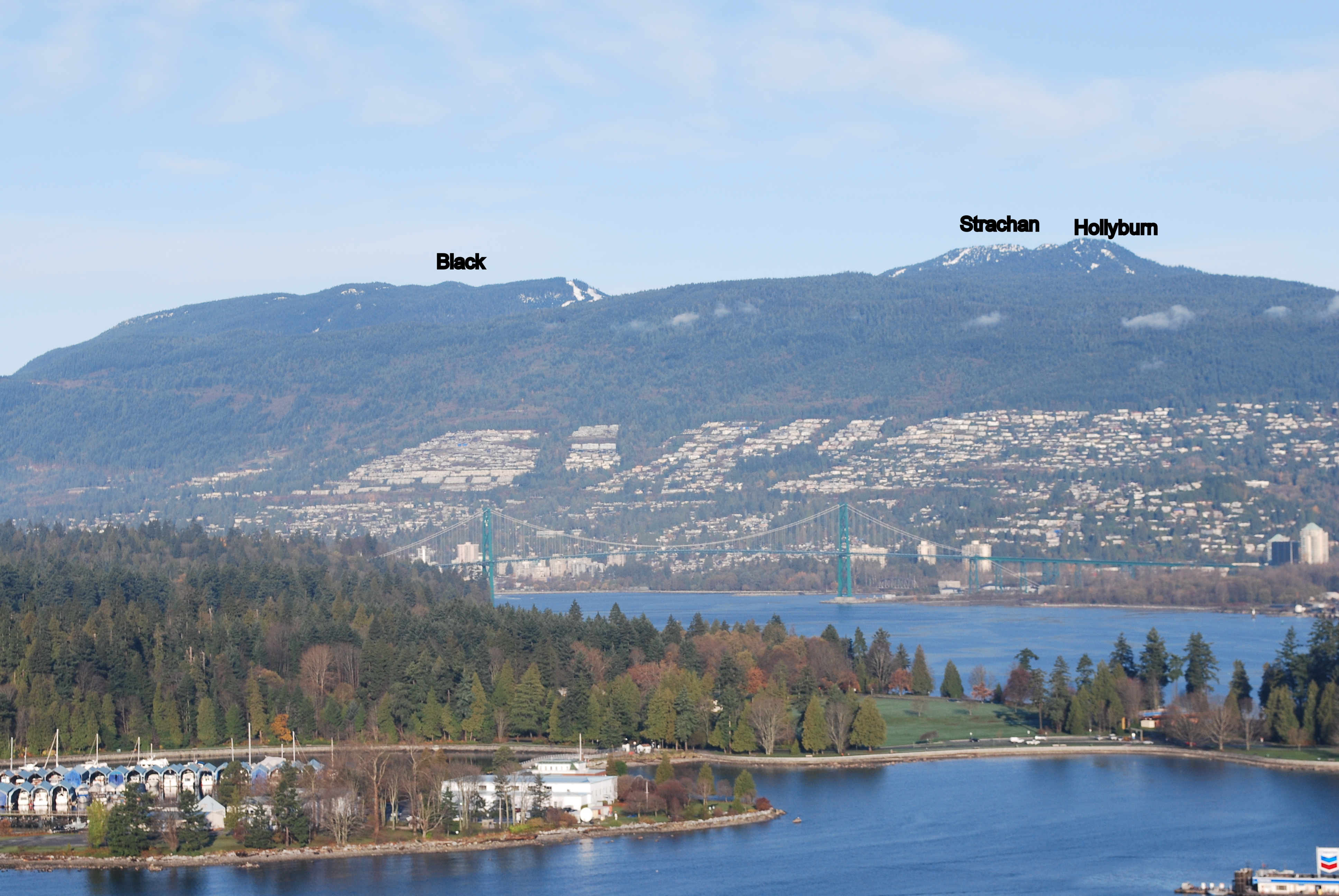
Jess and I (with Sierra on back) decided to do an easy bag of Strachan. This mountain turned us away at the first (lower) peak at the end of the bagging season last year as we encountered cold howling winds and experienced the first snowfall of the season. The north peak literally vanished before our eyes as the storm came in. The conditions made for a very unhappy 8 month old requiring us to make a quick decent without the bag. Fast forward almost 9 months ... Quite a different day. We took the easy way up and got to the surprisingly deserted peaks easily. Spectacular views (on 2 previous visits we were fogged out).
On my own today and after finding no takers (on late notice) for some bagging in the Fannin Range, I decided instead to make a trip out to Unnecessary Mtn. from Cypress Bowl. Another perfect day for running and bagging awaited. Lots of people out on the HSCT today. I'd never been to Unnecessary before but from the south (from St. Mark's Summit) it looks like a rather uninspiring treed wall in the way of the Lions.
An easy hour from Cypress got me to St. Mark's Summit and it's spectacular views north and west. After a quick side trip up to the true peak (a non-descript tangle of trees with no view to speak of) I headed off into uncharted territory (for me) towards Unnecessary.
Looking west from St. Mark's Summit
The climb up to Unnecessary is a grind but, as it turns out, very much worth the effort. The trees are replaced 3 rocky peaks offering amazing views west, north and south. I thought I had arrived at the south peak after about another hour but had forgotten to check on the CFA site which peak was the highest. The next peak was only about 15 minutes further so I headed further north. A short jaunt later, including some fun boot skiing down some of the remaining patches of snow brought me to a sign post lying on the ground -- Unnecessary Mountain South Peak 1540m. South peak. Hmm. Okay, well I could see the North Peak now, again, another 15 min or so away. Figured I'd better head to it to make sure I got the highest point. About 15 minutes later I got to the a sign on reading Unnecessary Mountain North Peak 1540m. Same height as the south peak! It was worth the extra effort though as the views of the Lions and other mountains north are unbeatable.
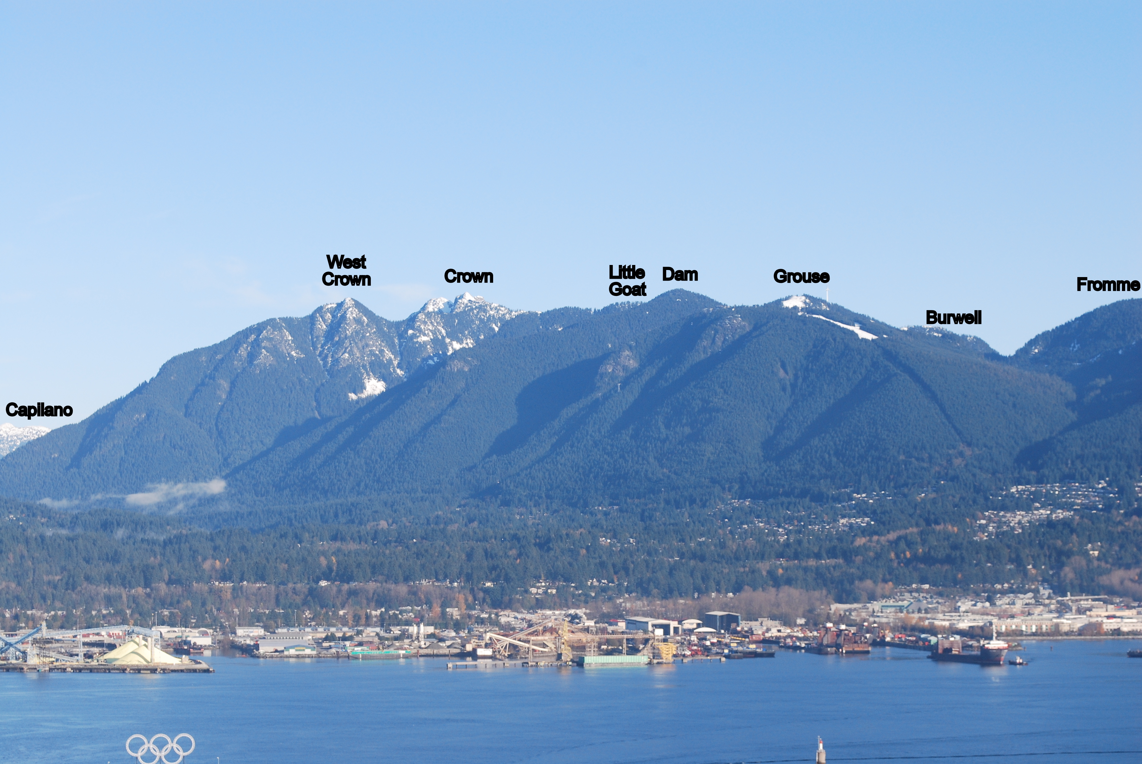
With Jess again (no Sierra), we decided to get a new bag for Jess's all-time list. After bouncing around several possbilities, we settled on Crown. Since they are pretty much directly on the way, we figured we might as well bag Dam and Little Goat also. Dam and Little Goat were quick, easy and uneventful. The only interesting caveat is that, for some reason, all of the trail signs have been removed. The big rock cairns that they stick in are present but the signs are nowhere to be seen (I'm guessing they are taken down for the winter and have yet to be re-installed). Fortunately, I've done the trails in the area enough times to figure out the right way to go.
Immediately at the junction between Crown and Goat Mountains we hit the first patch of snow. I didn't take this as a good sign but hoped for the best. It turned out that there were only a few small patches from there down to the col where the Haines Valley route comes up. Nothing of any significance.
The climb up to Crown is arduous but the effort is well-rewarded on a good day. Approximately 2:15 after leaving the Chalet, including small side-trips to Dam and Little Goat, we were at the top of Crown. Jess's words after climbing up the last little bit to the true peak -- Holy S**t F***ers! -- adequatey describe the precariousness of the location. I can't remember a time when she has uttered this particular phrase in the past -- interesting phraseology. Nobody else on the peak today made for a nice bit of solitude to take it all in. Due to the steepness, the return was only a bit faster than the trip out -- concentration not helped at all by the constant pestering of horse flies. Nevertheless, another rewarding day of bagging.
Submitted by David Crerar on 22 July, 2013 - 13:14.
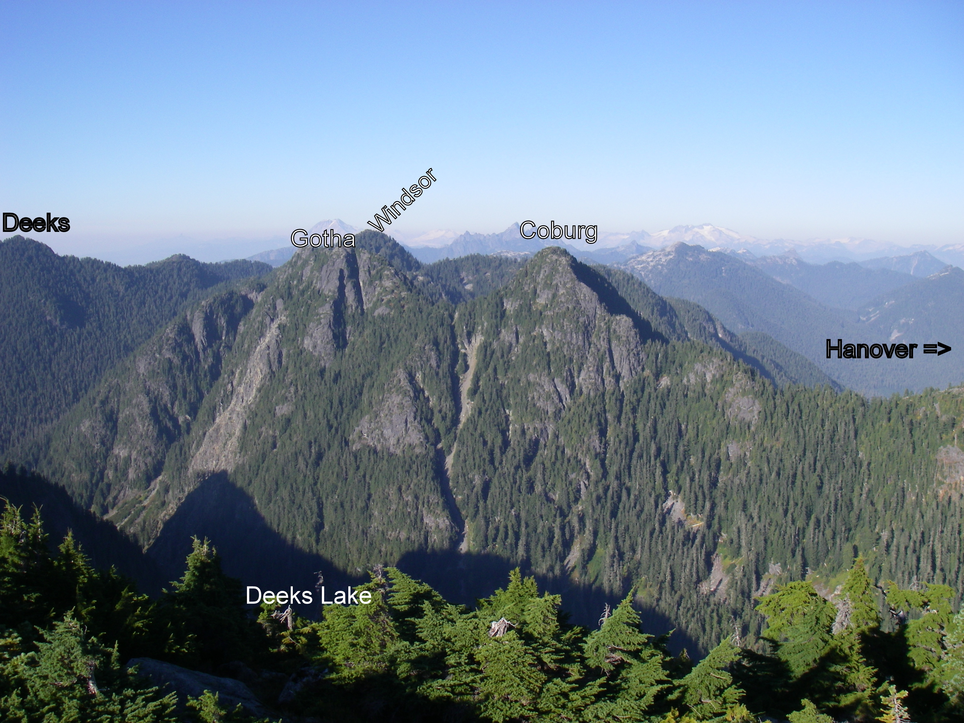
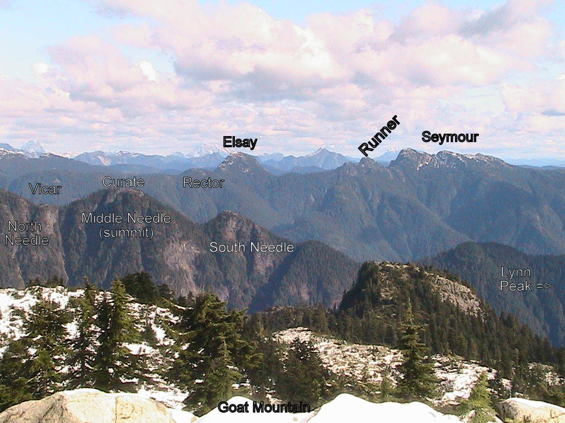
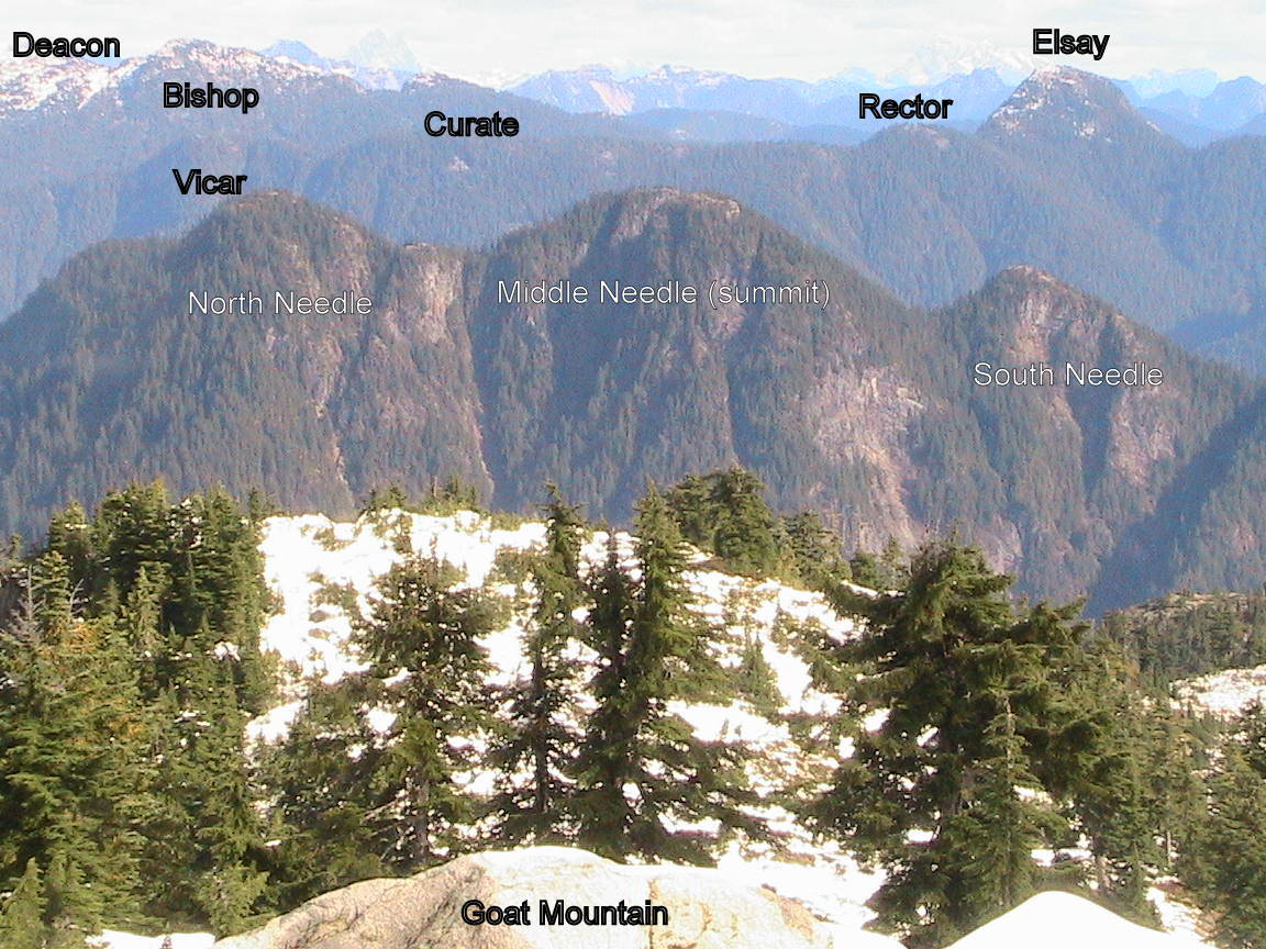
Glorious day to do a sweep of the Needles via Hydraulic Creek Trail. Hydraulic Creek Trail and trail to SNE is superb shape, and well-marked, although dry needles on the ground make for slippery underfoot.
The challenging bushwhack up to MNE has been made easier by a superb series of pink tape flagging (thank you, anonymous trail angels) to guide you past the cliff bands. The trail to NNE is also relatively well-marked. For my part, I did some clearance of the trial underfoot and underbrush. Still, considerable bushwhacking and routefinding (take care for hidden sheer drops, particularly en route to the North Needle) are necessary: this is no walk in the park.
From SNE summit to MNE, you can descend northward either off left end (NNW) or right end (NNE). From MNE to NNE, the descent is to the right (NNE) and will take you through and under two krumholtz formations.
Had to bank some elevation and to complete the Cypress group, so this happenned today:
Dip feet in water at Park Royal, up Cap Pacific to BP, up eastern Brothers Creek trail to the lovely yet bug-infested Lost Lake.
Traverse multiple blowdowns en-route to the just as lovely West Lake.
Join BP again and continue heading up north the x-country, then west to that bridge across one of Cypress Creek's branches.
Leave BP to take Old Strachan trail (first time on it, awesome, runnable) to the backside of Hollyburn, then attack from the north and bag HOL.
Back down the same way to the valley between Hollyburn & Strachan, continue up Old Strachan trail, through the 1963 plane crash site, to the south summit, down to the col and up to the north summit to bag STR. Do views get any better then on top of this peak?
Down the very steep, slippery, still snowy/icy Xmas gully to the highlight of my day: Coming down the narrow treed area of the gully, I came across your regular big group of very (too?) well equipped hikers making their way up. Stopping to let them by, a lady asks what happenned to me? I quickly glance down my legs thinking she's seeing the usual bloody cuts from clearing blowdowns, but no, legs are clear. What do you mean, I ask. She says, your pants and shirt are all wet. Yes I tell her, that is called sweat, and I was running...Weird, I know.
Take HSCT south, detour via the serene (at this time) Yew Lake, to the Alpine parking lot. Head to the south end of the lot, down 3-bears ski-run to the Raven base ski-lift, and take TCT/East Cypress Creek trail all the way south to the Cypress works-yard.
Catch Old Forks trail on the other side of the road, down to TCT/Skyline junction, head east along TCT, clearing the short washed-out section.
Down Brewis trail, left to Millstream trail/road, BP to dam, and Shinglebolt/Cap Pacific back to Park Royal.
Baggermeister: Water bag for STR and HOL; regular bag for BLA (via the - snif - "Not The Knee Knacker" run on Jul 6).
Jess, Sierra and I diaper bagged STR today. When we were up there it was deserted (around 11:30 am). Saw a few people heading up while we were on our way down. Sounds like an awesome run.
BTW, you only get to claim a water bag for one of those peaks (I'd pick the further one).
Getting good training in for Angel's Staircase, I see.
On Friday, I set out from the Grouse parking lot to conquor Mt. Fromme. It went like this: Baden Powell, St. Georges, Peer Gynt, Bill's to the summit. Then I dipped down and back up to lay down on a sunny rock upon the prominence challenged Senate Peak before heading down the slightly more sketchy west side until I met up with Pipeline, where I had a look at the Eric The Red signage and thought to myself that I should come back some day and go down that trail. Back out on the road, I turned off on a little trail that I'd never been on before, Iroc. The trail was in bad shape with lots of blowdown and whatnot and then for a while I did some light bushwhacking along Mosquito Creek. Soon I was back at the road, down St. Georges, Baden Powell and done.
Today I went back to have a look at that Eric The Red trail. I again started at Grouse, up BCMC, down the road, Pipeline to Eric The Red. This was a first for me. The trail is almost overgrown in places, but it was easy enough to get through. There's a little boulder field and a creek crossing and then it's up, up and away. Eventually things level out as it goes through a couple little fields and by a couple tarns before meeting up with Thunderbird Ridge. From there I didn't bother with Dam or Little Goat, but headed straight to Goat. There's still a bit of snow here and there, but nothing that would be problematic. I looked around for a few minutes, got eaten alive by all manner of flying beasties and headed back to the chalet and down BCMC in record time.
It was a good couple of days and I was thinking about heading out for more tomorrow, but a toenail decided to go all kamikaze on me on the way down BCMC, so maybe on Sunday I'll just rest instead.
Andy, you can try this return route variation next time:
When you come down the trail you called "Iroc" and hit the *Old* Grouse Mountain Hwy, take a right (instead of left), ford Mosquito creek, and continue along this flat but overgrown trail. A few minutes after passing the Dreamweaver junction on your left and entering the woods again, you'll come to another flagged junction and decision point: Either take left and down the Heritiage Tree trail, or right and slightly up a few minutes to a junction with Skyline/Jetboy which you take left and down. Either decision will spit you out at the bottom of Skyline at BP, just west of the Mosquito Creek bridge.
Note: Heritage Tree trail at sections may be a blowdown mess, but an enjoyable one.
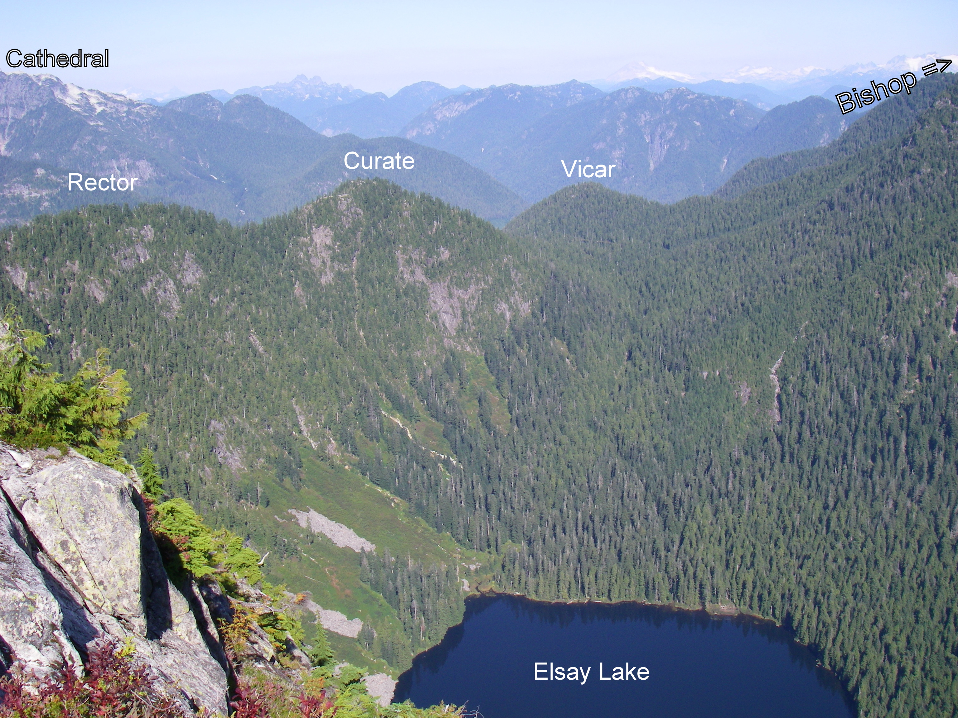
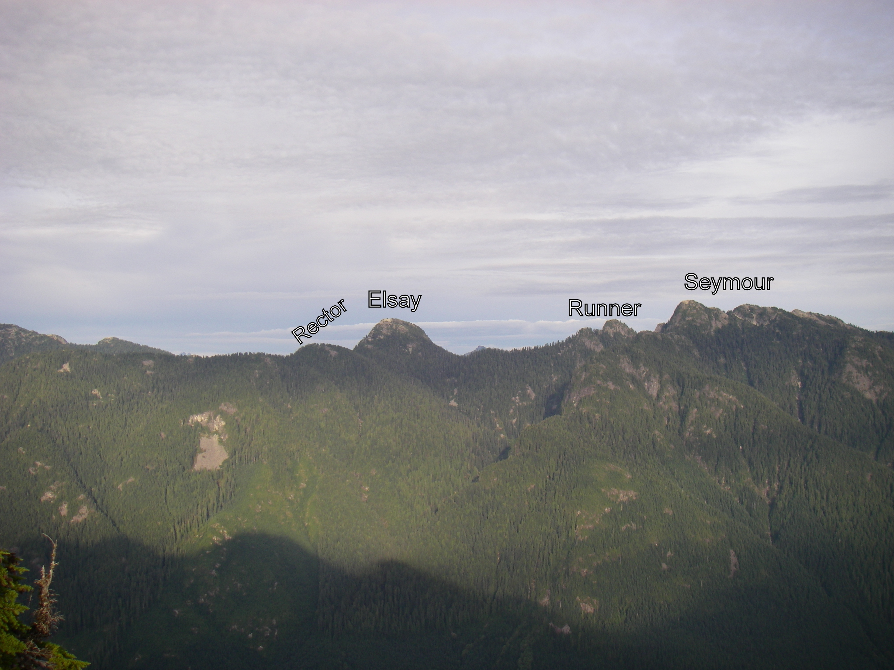
I was thinking of bagging Runner Peak and Mount Elsay in Seymour Provincial Park tomorrow (Sunday) and there's a 16 km loop you can do via the Elsay Lake trail. Anyone interested?
I am organizing 2 sweeps this weekend, the Seymour sweep on Saturday July 20 and the Lions sweep on Sunday July 21.
Saturday's sweep will do all 8 summits in the Seymour Range via a 44km loop that's never been done before in a single day. It will include: Suicide Bluffs, De Pencier Bluff, Seymour, Runner, Elsay, Rector, Curate, and Vicar. The return involves a 15km run via the Spur 4 road and Fisherman's trail. Sunday's sweep will be a relatively more modest 4 summits including: West Lion, St David, St James, and Harvey. A large part of this trip is spent in the alpine.
I am recommending running shoes and micro spikes as most of the snow is gone now.
Submitted by adventuremike on 22 July, 2013 - 13:31.
Joined Bill and Paul for this fun and enjoyable sweep. Took approx. 9h 30 min with a nice easy pace for most of the time, nice breaks at the summits. Bill took it easy on us after his epic Seymour sweep on Saturday where he finished up just 7 hours before starting the Lions sweep!
It's there, the pins overlapping seems to have removed the label and it's opacity is turned down. Actually Fromme seems to have done the same thing. That was about the best screenshot I could take of such a crowded map.
If you click through to the KMZ file you can see all the pins much clearer.
If you are tempted to find a better route up this one, let me disabuse you of a few notions. I did summit just after 4pm on a lovely Sunday of a long weekednd, but that is hardly the tale.
I had read all that I could find about the route, and initially set out only to do a recon of the ridge ...... but .... one thing leads to another as we all know.
Ran up to Norvan and was at the Lynn crossing in just over an hour, to find Lynn Creek as high as I had seen in a few years. This led to an ungainly (But very effective) straddling of the second log crossing and onwards towards Hanes. I passed the second dry creekbed noted in some Clubtread route reports, but could not remember offhand if there was ANOTHER dry creekbed, so continued on until it was obvious I had gone a little too far.
Not to worry .... found a small stream at a fairly gentle grade about halfway between the dry creekbed and the Hanes NSR cache, and started up the ridge.
This is a fairly dense bushwhack to start .... but you think it must get better. IT DOES NOT!!!
In point of fact, it gets worse about halfway up .... the brush becomes so thick that you need to part it so that you can see the lay of the ground before blithely stepping down. How did I learn this, you ask? Well, lets just say after a misstep, I ended up with a Devil's Club up my shorts .
THIS IS NOT AS MUCH FUN AS IT SOUNDS. I can assure you it is not one of the great experiences of life nor am I in a great hurry to repeat it.
But I digress ... continuing the bushwhack eventually led me to a clear and running creekbed about 3/4 of the way up which I was able to follow almost the rest of the way. There were a few areas of rotten snowcover, though I suspect that would be completely gone by now. Once out into the alpine, I could clearly see the col I was aiming for and it was a straight shot to it. Some nice scrambly bits to the ridge and proper and you are hard on the slopes of Crown N1. Follow the ridge spine with one deviation at a cliff band (I went to the left) and over a subpeak and the summit is in clear view.
I would think it possible to come down a more direct route with more mountaineering experience than I have, so took the same route back to the creekbed. Followed the boulder field down and then cut back into the underbrush about two thirds of the way down and cut back east. Doing it again, I would not do this and attempt to take the boulder field directly out to where you could hook into the Hanes Valley trail near the start of its boulder traverse.
Conclusions ? ..... try the route listed by oldmatt and burning boot on Clubtread as it sounds like that would avoid the horrendous bushwhack.
OR ..... consider the direct boulder approach. I will be going back this year and am considering a Crown N1/Perrault loop though that would be a full day indeed.
Hope I can join you on this one. Had thought about doing the needles this weekend, but figured I'd wait for some more snowmelt. South needle was completely clear when I did it in mid May last year, I think we've got a lot more snow on the ground right now though.
I've been checking clubtread almost daily hoping for a report from up there.
Submitted by David Crerar on 28 June, 2013 - 11:55.
Any Peak Baggers this weekend: please report back to your fellow baggers how nice or nasty the snow conditions are on the peaks, and how low down the snow slogging starts.
Last weekend the trail to Dam had a good amount of hardpacked snow, around 2 feet I suspect. Would recommend micro-spikes to anyone heading up that way this weekend.
I started down the other side of Dam towards Little Goat a couple days ago but the icy conditions turned me back. It might have been fine but common sense got the better of me. Probably fine with spikes.
With the Chicago Blackhawks winning the Stanley Cup again, I wonder if any member of the current team will try to match the Cup bag that was achieved last time the Hawks won the Cup. Here is BC boy Andrew Ladd with the Stanley Cup atop Crown in the summer of 2010. Brent Seabrook is from Richmond so would be the most likely candidate to join CFA and bag a couple.
Saw a single picture of this the other day, just him and the cup and the mountains, didn't even occur to me that it could be the north shore mountains. That's pretty awesome.
Submitted by Ean Jackson on 25 June, 2013 - 11:40.
A most loyal companion, indeed.
While I have bagged but a handful of peaks so far in 2013, today I dialed-up my commitment to training for the Baggers Banquet to another level.
You can, too, by purchasing "The Whiskey Companion" by Helen Arthur. At $5.99, it's a deal that any true Scot would apprecite. Some still available at Chapters...
Bagged Black Mountain (BLA) (twice, actually) doing an out-and-back from Nelson Canyon to the Hollyburn xc ski trails above Cypress as a modified KKNSTR training run. Surprisingly, it looked very much the same both times! Please mark me down for one Black Mountain conquest.
Left home on Saturday June 15th by bike at 7:10. Parked bike in bushes at edge of Horseshoe Bay Park on east side of Nelson Ave. Caught Cormorant Water taxi to Camp Fircom at 8:45. Started hike at 9:30 under mostly clear skies.
Key times:
Saturday
07:10 Left home on Riverside by bike
08:45 Cormorant water taxi to Fircom
09:30 Camp Fircom
11:00 Top of Artaban
12:00 Brigade Bay
14:20 Top of Burt's Bluff
15:10 Lost Lake
16:45 Gambier Lake
19:00 Gambier Peak
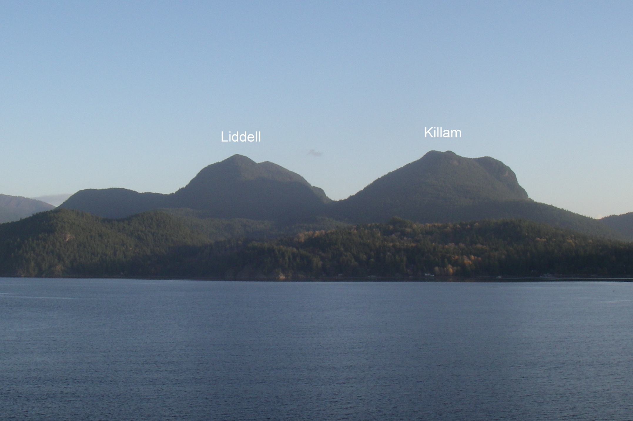
19:45 Mt Liddell
21:15 Base of Killam
Bivvied next to Mannion Creek very warm and comfortable in my Big Agnes UL1 tent (w/o poles or fly), Merlin 0C sleeping bag, and Thermarest Neoair sleeping pad. It was good to have the tent rather than the fly because it protected me from the mosquitoes which were buzzing around all night. There was no protection from rain with this setup.
Sunday
07:15 Base of Killam
09:15 Top of Mt Killam
11:10 New Brighton
11:55 Stormaway
12:20 Queen of Sechelt
13:15 Horseshoe Bay
15:15 Arrived home by bike
Cycled back home from Horseshoe Bay arriving at 15:15.
Wow, Gulf Islands completed in pre season! Still finding the Challenge challenging in my third season. Trashed another pair of runners on this trip. Did the same thing in 2011. Saw Richard's entry in the summit register and entered another comment below.
Route finding for this trip would have proven significantly more difficult without the assistance of my Samsung Galaxy GPS running OsmAnd with offline maps. I have posted the island's summits and trails on openstreetmap.org now so these will be visible on any OSM client app. I have not posted the bush routes where no trails exist which include the descent from Burt's Bluff to Lost Lake, the descent of the SE flank of Liddell, and the ascent of the SW flank of Killam.
The entire route is available on the following gpx track:
I had cell reception at the top of Artaban, Burt's Bluff, Gambier, Liddell, and Killam but none at Lost Lake, Gambier Lake, Mannion Creek, or New Brighton. Basically, there is only reception at the tops of the peaks and none in the valleys.
There is no snow remaining anywhere on the island this year.
The Cormorant Water taxi price is $25 per person and leaves the Horseshoe Bay public dock at 8:45 on Saturday mornings. Call Brian at 604-250-2630 to make a reservation or to set up an alternate time. The Stormaway sailing to Langdale costs $6.95 and the return sailing from Langdale to Horseshoe Bay is free.
Future goal is to do the traverse over Killam on the 1st day so need to speed it up. There was lots of new blowdown on the route this year particularly in the creek descending from Liddell.
As part of Pacific Road Runner's unofficial "Not the ..." series, 3 of us ran from Ambelside to Grouse Mountain as our "Not the Seek the Peak" event yesterday (Tuesday) evening. In spite of the less than optimal forecast, we somehow managed to skirt the rain and, in fact, had sunny skies for much of the route. The wind is mighty chilly up on Grouse right now though. Not summer there yet!
Was sort of hoping to hit up Killam during the group outing, but my younger brother had this weekend free so I dragged him up there. Took a lot of encouragement but we made it. A nice cloudy day made the walk along the dirt roads leading up a much more plesant experience.
Camped just above the viewpoint but ended up having a very foggy night and morning.
We took off for the ferry in the morning and when I realized we could probably catch an earlier boat Kurtis found a second wind and we ended up jogging down most of the road back. I'm not sure if that's such a good sign for future bags with him.
If anyone is so inclined, they might want to bring a screw driver to fix this summit marker. It's down by the viewpoint though, so fairly superflous. I didn't notice the screw type.
Also, there was a very well trodden looking trail that intersected the trail to Killam at N49.47548 W123.42465 does anyone know where this leads? Is it safe to say the Gambier Island trail map http://www.gambierc.ca/map.html hasn't been updated in a while?
Counting on the "Clouds in the morning clearing by noon" forecast, Jess and I thought it would be a good opportunity to diaper bag Fromme. Opting for the shortest route possible, we parked the Westy at the top of Skyline Dr., loaded up and headed off around 10:45 am. Even though it was rather misty, we were still hopeful that the weather forecast would pan out. The ascent to St. George's bench after the brief drop to Mosquito Creek was quicker than I expected (~23 min), including having to step to the side of the trail a number of times while runners participating in the Red Bull Divide and Conquer made their way down towards Mosquito Creek. Another 25 minutes got us up St. George's to Mountain Highway. Still no snow on the ground. Still misty. Still optimistic. Up Per Gynt to Mountain Highway again for a total time of about an hour. Trails so far all in good condition. Still no snow.
Straight across Mountain Highway and onto Bill's trail. Bill's trail is normally a sweet traverse around the gravel pit before heading up to Fromme but right now is a total mess in the gravel pit area. The chainsaw crews have done a ton of work cutting up all of the significant deadfall but has yet to clear the cut debris from the trail. Give it a couple of weeks and I expect it will be fine but, right now, you might be better served to bypass this section by going through the gravel pit.
Carrying on through the debris and beyond the gravel pit where the going got easier, we were making fairly good time. Came upon another lone hiker heading towards the peak also. Finally ran into snow on the trail beyond where I've seen it in July sometimes. Unfortunately, the weather clearly wasn't going to meet the forecast expectations and the combination of snow and foggy/misty conditions dropped the air temperature significantly. Sierra hung in there for quite some time despite cold hands but finally made it clear that she was not the least bit amused. We stopped in the trees and piled on every bit of spare clothing we could find, including socks and Jess's gloves on her hands to see if that would help. We estimated we were only about 15-20 minutes below the peak at this time but seriously considered turning around at this point. Fortunately, the extra protection was enough to warm Sierra up to the point where she promptly fell asleep!
Somewhat hurried, we made the final ascent to the peak. Absolutely no view today, unfortunately. Still lots of snow at the peak. The lone hiker, who had passed us during Sierra's meltdown, was already there and did the honours of taking our standard peak bag photo.
Fromme Bagged
Had some snacks at the peak but didn't hang around too long as we wanted to get as far down and out of the cold as we could before Sierra came to again. The going was pretty slow down through the snow as it is rather slick right now and with the extra weight of Sierra and the pack making my centre of gravity higher than usual, it made it even more sketchy. At any rate, we made it down with only one wipe out (Sierra didn't wake up). Made it back to Mountain Highway in about 60 minutes from the peak.
By the way, if you're planning on diaper bagging right now, I would highly recommend using poles (even if you're not). There were several places where I think I would have had some serious difficulty (coming down, mostly) without the poles.
The rest of the descent down St. George's and the BP back to Skyline Dr. was fairly quick and uneventful except for one incident on the BP where I caught a slip but, in the process, tweaked my right knee rather painfully. Made plans to put a beer on it when I got home
Total return trip, excluding probably around 15 minutes bundling up Sierra was exactly 4 hours.
Bagged Gardner (GAR) for the second time this year (and second time ever). Not coincidentally, it was another spectacular day. This time around it was more of a running expedition than a hike as it was about 1 month ago when I was with Jess and Sierra on my back. Starting at Snug Cove John Neels, Susan Reynolds, Terry Bushnell and myself made the standard run up to Killarney Lake. To add a bit more mileage we opted to go the long way around the lake before heading up Gardner. Shortly after the gate on the gravel road up the mountain, we took the Skid Road trail which eventually merged into the South Summit trail. This route is a lot nicer as it completely avoids the road and brings you around the back side of the mountain just below the South Summit. A quick little steep section through a bit of blowdown brought us to the South Summit (no view).
After performing the obligatory photo and rock additions to the cairn, we quickly made our way though the significant dead fall to the much more scenic North Summit heli-pad. Took more photos, ate snacks and made full use of the heli-pad for a bit of relax time. Re-directed John and quickly made our way over to the north-facing heli-pad, at which point the others realized they had never actually been at the previous heli-pad before -- they'd always stopped here and assumed it was "the" heli-pad! Forced to stop and take in the north views now.
Headed down the North summit trail (through much blowdown) and opted to take Handloggers Trail to make it more interesting. Interesting it was. After negotiating extensive blowdown (repeat), the trail is exceptionally steep and, right now, very much like running down a watered-down slide -- one that you have to corner on! We almost made it to the bottom intersecting trail without casualty. Almost. Unfortunately, just before getting there, Terry went horizontal and took the full brunt of the mountain on his hip. This made the rest of Terry's descent rather painful and considerably slower. Once we got back to the gate (Terry and Susan by the road; John and I by a quick side trail), Terry, wanting to not be a burden, flagged us all off for the return trip around the lake while he headed back by road.
Please add an asterisk to my GAR bag and add John, Susan and Terry for GAR*. (Not that they asked to but it seems like a good covert way to get them into the glory that is bagging.)
Carlie and I did a Waterbag of Grouse this morning. We were foolish enough to think we could beat the crowds. There is no beating the crowds on a sunny Sunday at Grouse. Well ... maybe if you bring a headlamp.
Submitted by David Crerar on 1 June, 2013 - 19:49.
It is heartily recommended that serious baggers subscribe to BIVOUAC.COM, the online encyclopaedia of peaks, with a focus on BC peaks, but with peaks far beyond. Routes, stats, photos, maps, and discussion. Only $50 for 3 years.


Comments
August the 11th would work
August the 11th would work for me, no preference on destination, Mr Stetson says why not run in along Lynn Valley for extra KM's and then head to Coliseum and Burwell.
Hey James, maybe on the 11th
Hey James,
maybe on the 11th we could finally try and drum up some support to do the Howe Sound Crest Trail (even if it's technically not a bagging adventure).
I have plenty of time that day, but unfortunately no car, so we would need a few more people to join us.
Marc
St. Mark's
Off the HSCT, there is a obvious and useful side-trail just to the north of the signpost marking "St. Mark's Summit" (which the viewpoint is of course not), leading to the true summit of St. Mark's. The two-minute side-trail wends its way around and behind the summit knoll and then up to the peak: a woody bump marked by a stumped tree. Apart from taking you to the peak, it gives some nice backdoor view of Enchantment, Wizard, and Magic.
Slanted and Enchanted
Enchantment Peak is worth a visit, especially to those who blanch at climbing the West Lion and have an hour to spare in that section of the HSCT. Not an easy side-trip but not a difficult one.
Access is via the small cirque lake just NE of the Lions (there may be a safe way to approach it from the N, from the nasty scree slope on the HSCT, via Enchantment Lake). From the small unnamed lake, do not be tempted to cut straight up to the inviting western ramp heading up Enchantment. Instead, descend, to the NE, before cutting over N to a boulder field (there is a sweet and painless route, but your route may involve bushwhacking). Across the boulder field and ascend via a fallen tree and a modest creek bed. Then mild bushwhacking NE to the rocky patio at the base of Enchantment, leading to the aforementioned ramp straight up to the peak, past a few small tarns. Unusual views of the Lions (Including a twin waterfall coming off two ice fields at the base of East Lion) and a clear view to Sky Pilot and the Black Tusk make this a worthwhile diversion. Be cautious of the sheer cliff to the north: a long and unpleasant tumble into Enchantment Lake.
Do not be tempted venture south to Wizard: The Wonderful Wizard and the Magically Endless Ridge is a book not worth reading. And the only likely magic about Magic, to the south, is the joy of making it magically disappear from your to-do bagging list.
The Fannin triathlon
The 2013 Fannin multi-leg triathlon (olympic distance) was held today in dry conditions and warm water temperatures.
At the absurdly late hour of 10 am, this participant cycled off the start line at the LSCR gazebo on his heavy, fat-tired mtn bike, north along the Seymour Valley trail, on the first 11 km bike leg.
He crossed the new & awesome Bear Island bridge, and stashed the bike in the woods upon regaining the eastern logging road.
The second leg included running/hiking up the Vicar Lakes trail, quick stop for food at the big-lake aid station, regaining the Mt. Bishop trail and continuing east & up along it until reaching the alpine level meadows.
The third leg comprised of a south-east scramble up to the peak of Mt. Bishop, back down to the col, a north-east scramble up to the peak of Mt. Deacon, down & north to another col, and a final northern scramble up to the peak of Mt. Presbyter.
Refueling again at the aid station on top of Presbyter, one could only look in envy at a sparkling Fanin lake way down below, and Mt. Dickens (of bagger legends fame) towering north above it.
The fourth leg saw a southbound down scramble, trying to maintain the 1370 m countour line until back at Bishop meadows, and back down to Vicar lakes.
Transitioning to the swim leg at Vicar was shockingly fast, unlike the swim itself (length of the big lake, return) - The water were just too good to leave.
Another refueling, transition back to running shoes & pack, and downhill technical running/jumping/multi-rope-evading dash down Vicar Lakes trail to the logging road.
Final leg: un-stash bike, put on helmet, and ride back the 11 km along the Seymour Valley trail to the finish line at the Gazebo.
Final two thoughts: Apart from the 2 bike legs, the crowd support for all other legs of this triathlon was disapointingly yet awesomely completely non-existent; and next year, this participant may try the half-ironman version of this triathlon, which shifts the swim to Fannin lake, and extends the scrambling to Mt. Dickens.
Baggermeister: BIS, DEA, PRE please.
EPIC!
Isn't Fannin Lake gorgeous?
St. Mark's, Unnecessary... Coliseum, Burwell.
On Thursday afternoon I set out from Cypress Bowl and conquored St. Mark's and Unnecessary Mountain. My trip reads pretty much like Bill's below, so I'll spare you the details. Pretty much as soon as I turned around to head back to Cypress, my stomach decided to go south on me, so the trudge to the car was a sucky, painful, doubled over slog. I told myself that the next day I was going to the beach instead of the mountains.
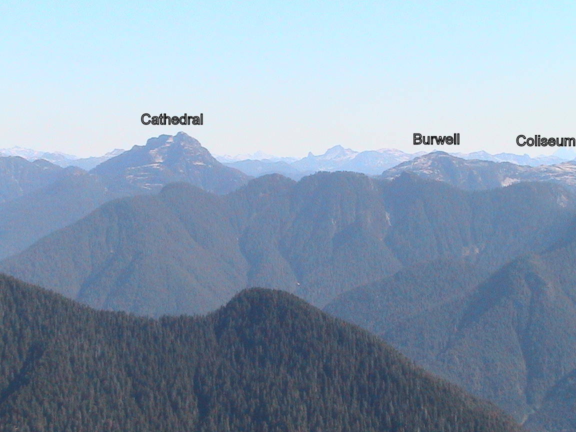
A good night's sleep had erased any lingering thought of lounging on the beach all day and on Friday morning I headed out to Lynn Headwaters to have a go at Coliseum Mountain and Mount Burwell. Once you get to Norvan Falls and hang a left, the uphill slog commences. That first climb is a beast. Once over that initial obstacle, the trail cuts left and there's a few runnable sections through boggy bits, meadows and across a couple little creeks. The trail continues up, up and away until a couple of near vertical climbs spit you out on the rocky alpine area. A little farther along is the Coliseum summit. It was a bluebird day with crazy 360° views. Then it was onward to Burwell. Once past Coliseum it's pretty much all rocky, alpine terrain. I messed around quite a bit through here, climbing things and generally taking the long way around. I stopped at a beautiful, clear blue, freezing cold pool and contemplated going in for a dip but just soaked my feet for a spell instead. At the summit of Burwell, the views again were spectacular. The next peak to the north is the menacing looking Cathedral Mountain with Palisade Lake far down in the valley below. I sat and ate some almonds whilst hanging out with the ravens and the horse flies before retracing my steps and heading for home. Total time, including all the mucking around, was about 7.5 hours.
Beautiful!
Looks awesome! Colliseum and Burwell are both on my hit list for this year. All clear of snow now I gather.
Bill's Great Peak(s) this Sunday a Bagger's Delight!
Bagger's take note, Bill's Peak(s) Ascent will be a Bagger delight this Sunday. You can bag up to 5 peaks in one sweep. Check out the details here:
http://www.clubfatass.com/events/BillsGreatPeak
STR (Diaper); MAR; UNN; DAM; LIL; CRO
3 glorious days; 6 peaks.
Day 1 - Saturday, July 20, 2013:
Jess and I (with Sierra on back) decided to do an easy bag of Strachan. This mountain turned us away at the first (lower) peak at the end of the bagging season last year as we encountered cold howling winds and experienced the first snowfall of the season. The north peak literally vanished before our eyes as the storm came in. The conditions made for a very unhappy 8 month old requiring us to make a quick decent without the bag. Fast forward almost 9 months ... Quite a different day. We took the easy way up and got to the surprisingly deserted peaks easily. Spectacular views (on 2 previous visits we were fogged out).
Looking north from the north peak of Strachan
More Photos
Day 2 - Sunday, July 21, 2013:
On my own today and after finding no takers (on late notice) for some bagging in the Fannin Range, I decided instead to make a trip out to Unnecessary Mtn. from Cypress Bowl. Another perfect day for running and bagging awaited. Lots of people out on the HSCT today. I'd never been to Unnecessary before but from the south (from St. Mark's Summit) it looks like a rather uninspiring treed wall in the way of the Lions.
An easy hour from Cypress got me to St. Mark's Summit and it's spectacular views north and west. After a quick side trip up to the true peak (a non-descript tangle of trees with no view to speak of) I headed off into uncharted territory (for me) towards Unnecessary.
Looking west from St. Mark's Summit
The climb up to Unnecessary is a grind but, as it turns out, very much worth the effort. The trees are replaced 3 rocky peaks offering amazing views west, north and south. I thought I had arrived at the south peak after about another hour but had forgotten to check on the CFA site which peak was the highest. The next peak was only about 15 minutes further so I headed further north. A short jaunt later, including some fun boot skiing down some of the remaining patches of snow brought me to a sign post lying on the ground -- Unnecessary Mountain South Peak 1540m. South peak. Hmm. Okay, well I could see the North Peak now, again, another 15 min or so away. Figured I'd better head to it to make sure I got the highest point. About 15 minutes later I got to the a sign on reading Unnecessary Mountain North Peak 1540m. Same height as the south peak! It was worth the extra effort though as the views of the Lions and other mountains north are unbeatable.
View north from Unnecessary North Peak
More Photos
Day 3 - Monday, July 22, 2013:
With Jess again (no Sierra), we decided to get a new bag for Jess's all-time list. After bouncing around several possbilities, we settled on Crown. Since they are pretty much directly on the way, we figured we might as well bag Dam and Little Goat also. Dam and Little Goat were quick, easy and uneventful. The only interesting caveat is that, for some reason, all of the trail signs have been removed. The big rock cairns that they stick in are present but the signs are nowhere to be seen (I'm guessing they are taken down for the winter and have yet to be re-installed). Fortunately, I've done the trails in the area enough times to figure out the right way to go.
Immediately at the junction between Crown and Goat Mountains we hit the first patch of snow. I didn't take this as a good sign but hoped for the best. It turned out that there were only a few small patches from there down to the col where the Haines Valley route comes up. Nothing of any significance.
The climb up to Crown is arduous but the effort is well-rewarded on a good day. Approximately 2:15 after leaving the Chalet, including small side-trips to Dam and Little Goat, we were at the top of Crown. Jess's words after climbing up the last little bit to the true peak -- Holy S**t F***ers! -- adequatey describe the precariousness of the location. I can't remember a time when she has uttered this particular phrase in the past -- interesting phraseology. Nobody else on the peak today made for a nice bit of solitude to take it all in. Due to the steepness, the return was only a bit faster than the trip out -- concentration not helped at all by the constant pestering of horse flies. Nevertheless, another rewarding day of bagging.
Dam Mountain
Little Goat
Top of Crown
More Photos
Summary:
Happy Bagging!
Bill's Great Peak Ascent -- New Bagger Focus; Only 6 days away!
Bill's Great Peak Ascent is this Sunday. This year it's all about bagging. Check it out. It's an easy way to get a bunch of peaks in one easy go.
Needled
The challenging bushwhack up to MNE has been made easier by a superb series of pink tape flagging (thank you, anonymous trail angels) to guide you past the cliff bands. The trail to NNE is also relatively well-marked. For my part, I did some clearance of the trial underfoot and underbrush. Still, considerable bushwhacking and routefinding (take care for hidden sheer drops, particularly en route to the North Needle) are necessary: this is no walk in the park.
From SNE summit to MNE, you can descend northward either off left end (NNW) or right end (NNE). From MNE to NNE, the descent is to the right (NNE) and will take you through and under two krumholtz formations.
Trail angel recognized
Bravo!
you found a very good route, sir!: better than the near-death experiences over the cliff bands in my three previous climbs.
STR and HOL the long and wet way round
Had to bank some elevation and to complete the Cypress group, so this happenned today:
Dip feet in water at Park Royal, up Cap Pacific to BP, up eastern Brothers Creek trail to the lovely yet bug-infested Lost Lake.
Traverse multiple blowdowns en-route to the just as lovely West Lake.
Join BP again and continue heading up north the x-country, then west to that bridge across one of Cypress Creek's branches.
Leave BP to take Old Strachan trail (first time on it, awesome, runnable) to the backside of Hollyburn, then attack from the north and bag HOL.
Back down the same way to the valley between Hollyburn & Strachan, continue up Old Strachan trail, through the 1963 plane crash site, to the south summit, down to the col and up to the north summit to bag STR. Do views get any better then on top of this peak?
Down the very steep, slippery, still snowy/icy Xmas gully to the highlight of my day: Coming down the narrow treed area of the gully, I came across your regular big group of very (too?) well equipped hikers making their way up. Stopping to let them by, a lady asks what happenned to me? I quickly glance down my legs thinking she's seeing the usual bloody cuts from clearing blowdowns, but no, legs are clear. What do you mean, I ask. She says, your pants and shirt are all wet. Yes I tell her, that is called sweat, and I was running...Weird, I know.
Take HSCT south, detour via the serene (at this time) Yew Lake, to the Alpine parking lot. Head to the south end of the lot, down 3-bears ski-run to the Raven base ski-lift, and take TCT/East Cypress Creek trail all the way south to the Cypress works-yard.
Catch Old Forks trail on the other side of the road, down to TCT/Skyline junction, head east along TCT, clearing the short washed-out section.
Down Brewis trail, left to Millstream trail/road, BP to dam, and Shinglebolt/Cap Pacific back to Park Royal.
Baggermeister: Water bag for STR and HOL; regular bag for BLA (via the - snif - "Not The Knee Knacker" run on Jul 6).
Missed you
Hi Ran,
Jess, Sierra and I diaper bagged STR today. When we were up there it was deserted (around 11:30 am). Saw a few people heading up while we were on our way down. Sounds like an awesome run.
BTW, you only get to claim a water bag for one of those peaks (I'd pick the further one).
Getting good training in for Angel's Staircase, I see.
Cheers.
Nice one!
Nice one!
Fromme and Goat.
On Friday, I set out from the Grouse parking lot to conquor Mt. Fromme. It went like this: Baden Powell, St. Georges, Peer Gynt, Bill's to the summit. Then I dipped down and back up to lay down on a sunny rock upon the prominence challenged Senate Peak before heading down the slightly more sketchy west side until I met up with Pipeline, where I had a look at the Eric The Red signage and thought to myself that I should come back some day and go down that trail. Back out on the road, I turned off on a little trail that I'd never been on before, Iroc. The trail was in bad shape with lots of blowdown and whatnot and then for a while I did some light bushwhacking along Mosquito Creek. Soon I was back at the road, down St. Georges, Baden Powell and done.
Today I went back to have a look at that Eric The Red trail. I again started at Grouse, up BCMC, down the road, Pipeline to Eric The Red. This was a first for me. The trail is almost overgrown in places, but it was easy enough to get through. There's a little boulder field and a creek crossing and then it's up, up and away. Eventually things level out as it goes through a couple little fields and by a couple tarns before meeting up with Thunderbird Ridge. From there I didn't bother with Dam or Little Goat, but headed straight to Goat. There's still a bit of snow here and there, but nothing that would be problematic. I looked around for a few minutes, got eaten alive by all manner of flying beasties and headed back to the chalet and down BCMC in record time.
It was a good couple of days and I was thinking about heading out for more tomorrow, but a toenail decided to go all kamikaze on me on the way down BCMC, so maybe on Sunday I'll just rest instead.
Return variation
Andy, you can try this return route variation next time:
When you come down the trail you called "Iroc" and hit the *Old* Grouse Mountain Hwy, take a right (instead of left), ford Mosquito creek, and continue along this flat but overgrown trail. A few minutes after passing the Dreamweaver junction on your left and entering the woods again, you'll come to another flagged junction and decision point: Either take left and down the Heritiage Tree trail, or right and slightly up a few minutes to a junction with Skyline/Jetboy which you take left and down. Either decision will spit you out at the bottom of Skyline at BP, just west of the Mosquito Creek bridge.
Note: Heritage Tree trail at sections may be a blowdown mess, but an enjoyable one.
Thanks, good to know. It's
Thanks, good to know. It's always a bit of a crap shoot trying out new trails on one's own. I'll try and remember this bit of intel for next time.
Anyone interested in Runner and Elsay?
I was thinking of bagging Runner Peak and Mount Elsay in Seymour Provincial Park tomorrow (Sunday) and there's a 16 km loop you can do via the Elsay Lake trail. Anyone interested?
Black Bag - Jackson
Conquered the summit during the 2013 KneeKnacker. Left my mark in a small partch of snow. (Warning... don't eat yellow snow.)
Q: What do you call four (4) consecutive years of bagging Black Mountain?
A: BLA, BLA, BLA, BLA
Seymour and Lions Sweeps scheduled for this weekend
I am organizing 2 sweeps this weekend, the Seymour sweep on Saturday July 20 and the Lions sweep on Sunday July 21.
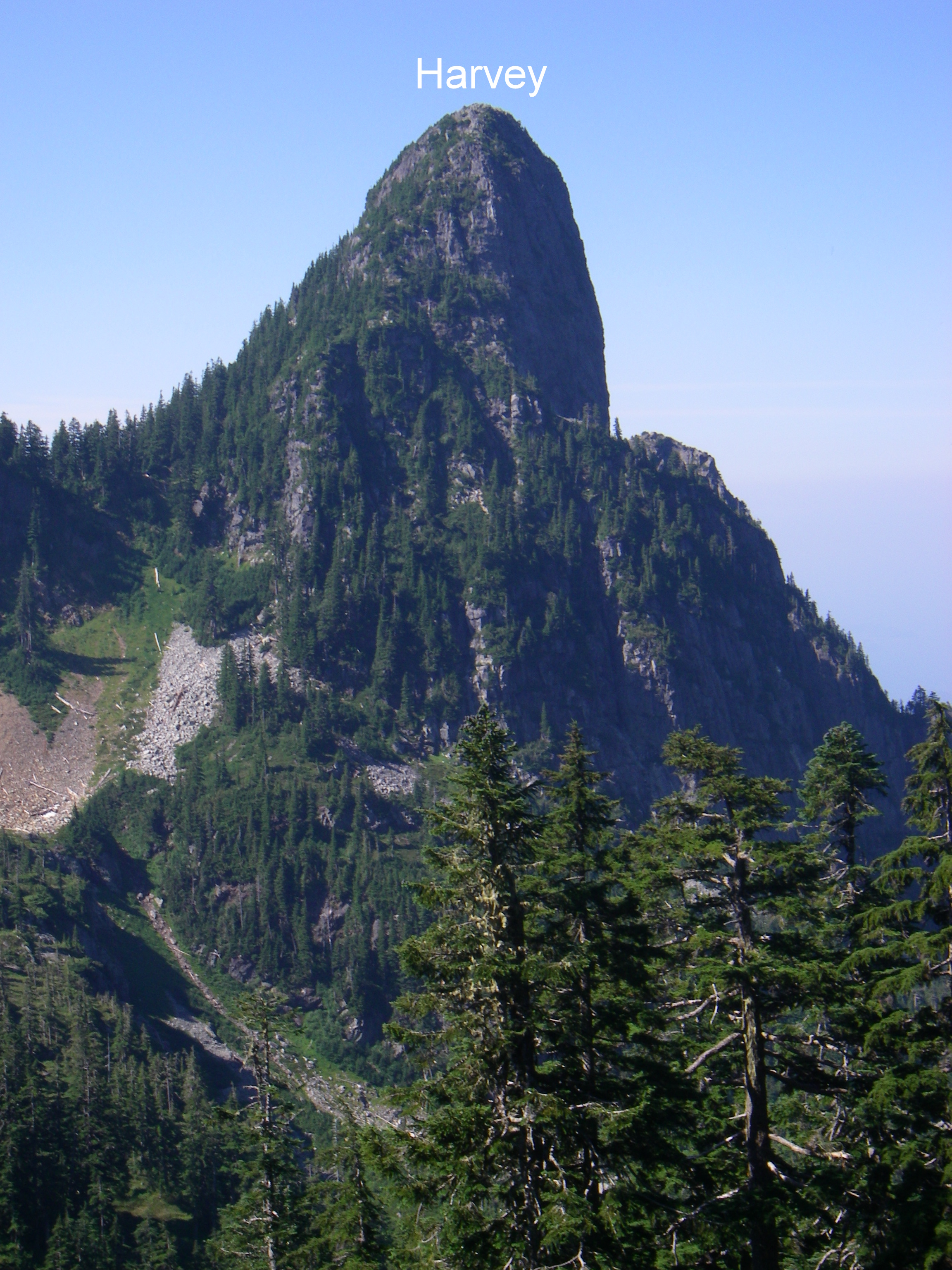
Saturday's sweep will do all 8 summits in the Seymour Range via a 44km loop that's never been done before in a single day. It will include: Suicide Bluffs, De Pencier Bluff, Seymour, Runner, Elsay, Rector, Curate, and Vicar. The return involves a 15km run via the Spur 4 road and Fisherman's trail. Sunday's sweep will be a relatively more modest 4 summits including: West Lion, St David, St James, and Harvey. A large part of this trip is spent in the alpine.
I am recommending running shoes and micro spikes as most of the snow is gone now.
If interested sign up here: http://www.meetup.com/BC-Outdoor-Adventures/events/128084742/ and/or here http://www.meetup.com/BC-Outdoor-Adventures/events/129981282/.
Note: I am screening participants for this trip so don't be intimidated by any wait list.
Bagged 4 summits: West Lion, St David, St James, and Harvey
Joined Bill and Paul for this fun and enjoyable sweep. Took approx. 9h 30 min with a nice easy pace for most of the time, nice breaks at the summits. Bill took it easy on us after his epic Seymour sweep on Saturday where he finished up just 7 hours before starting the Lions sweep!
Cheers.
Mike
I'm in for Sunday!
Anyone need a lift let me know.
Cheers.
Mike
love to do those two !
Have you checked the floor? (South Needle Pushpin)
It probably just fell out.
South needle?
The pushpin map is missing South Needle.
It's there, the pins
It's there, the pins overlapping seems to have removed the label and it's opacity is turned down. Actually Fromme seems to have done the same thing. That was about the best screenshot I could take of such a crowded map.
If you click through to the KMZ file you can see all the pins much clearer.
Uneasy lies the head that wears the Crown N1
If you are tempted to find a better route up this one, let me disabuse you of a few notions. I did summit just after 4pm on a lovely Sunday of a long weekednd, but that is hardly the tale.
I had read all that I could find about the route, and initially set out only to do a recon of the ridge ...... but .... one thing leads to another as we all know.
Ran up to Norvan and was at the Lynn crossing in just over an hour, to find Lynn Creek as high as I had seen in a few years. This led to an ungainly (But very effective) straddling of the second log crossing and onwards towards Hanes. I passed the second dry creekbed noted in some Clubtread route reports, but could not remember offhand if there was ANOTHER dry creekbed, so continued on until it was obvious I had gone a little too far.
Not to worry .... found a small stream at a fairly gentle grade about halfway between the dry creekbed and the Hanes NSR cache, and started up the ridge.
This is a fairly dense bushwhack to start .... but you think it must get better. IT DOES NOT!!!
In point of fact, it gets worse about halfway up .... the brush becomes so thick that you need to part it so that you can see the lay of the ground before blithely stepping down. How did I learn this, you ask? Well, lets just say after a misstep, I ended up with a Devil's Club up my shorts .
THIS IS NOT AS MUCH FUN AS IT SOUNDS. I can assure you it is not one of the great experiences of life nor am I in a great hurry to repeat it.
But I digress ... continuing the bushwhack eventually led me to a clear and running creekbed about 3/4 of the way up which I was able to follow almost the rest of the way. There were a few areas of rotten snowcover, though I suspect that would be completely gone by now. Once out into the alpine, I could clearly see the col I was aiming for and it was a straight shot to it. Some nice scrambly bits to the ridge and proper and you are hard on the slopes of Crown N1. Follow the ridge spine with one deviation at a cliff band (I went to the left) and over a subpeak and the summit is in clear view.
I would think it possible to come down a more direct route with more mountaineering experience than I have, so took the same route back to the creekbed. Followed the boulder field down and then cut back into the underbrush about two thirds of the way down and cut back east. Doing it again, I would not do this and attempt to take the boulder field directly out to where you could hook into the Hanes Valley trail near the start of its boulder traverse.
Conclusions ? ..... try the route listed by oldmatt and burning boot on Clubtread as it sounds like that would avoid the horrendous bushwhack.
OR ..... consider the direct boulder approach. I will be going back this year and am considering a Crown N1/Perrault loop though that would be a full day indeed.
Never a dull moment bagging though.
Dave
I
.
Bagger Series 4 - Needle / Lynn Peaks - July 6
North Needle, Middle Needle, South Needle, Lynn Peak, South Lynn Peak.
I am organizing a hike to bag all 5 summits in the Needle / Lynn range on July 6th.
I am recommending hiking boots, ice axe, and crampons unless reports from this weekend indicate no snow up there.
If interested sign up here: http://www.meetup.com/BC-Outdoor-Adventures/events/126910152/
Note: I am screening participants for this trip so don't be intimidated by any wait list.
The meeting point is at the Lynn Headwaters trail sign. I'm expecting this to take 8 to 9 hours.
Here's hoping
Hope I can join you on this one. Had thought about doing the needles this weekend, but figured I'd wait for some more snowmelt. South needle was completely clear when I did it in mid May last year, I think we've got a lot more snow on the ground right now though.
I've been checking clubtread almost daily hoping for a report from up there.
How are snow conditions up top?
Any Peak Baggers this weekend: please report back to your fellow baggers how nice or nasty the snow conditions are on the peaks, and how low down the snow slogging starts.
THANKS!
Dam snow...
Last weekend the trail to Dam had a good amount of hardpacked snow, around 2 feet I suspect. Would recommend micro-spikes to anyone heading up that way this weekend.
Dam ice...
I started down the other side of Dam towards Little Goat a couple days ago but the icy conditions turned me back. It might have been fine but common sense got the better of me. Probably fine with spikes.
2013 BAGGER CHALLENGE STARTS
http://www.clubfatass.com/blog/david-crerar/2013-bagger-challenge-starts
Cup Bag?
With the Chicago Blackhawks winning the Stanley Cup again, I wonder if any member of the current team will try to match the Cup bag that was achieved last time the Hawks won the Cup. Here is BC boy Andrew Ladd with the Stanley Cup atop Crown in the summer of 2010. Brent Seabrook is from Richmond so would be the most likely candidate to join CFA and bag a couple.
Saw a single picture of this
Saw a single picture of this the other day, just him and the cup and the mountains, didn't even occur to me that it could be the north shore mountains. That's pretty awesome.
that's about as good as life gets. Awesome.
.
The Whiskey Companion
A most loyal companion, indeed.
While I have bagged but a handful of peaks so far in 2013, today I dialed-up my commitment to training for the Baggers Banquet to another level.
You can, too, by purchasing "The Whiskey Companion" by Helen Arthur. At $5.99, it's a deal that any true Scot would apprecite. Some still available at Chapters...
http://www.chapters.indigo.ca/books/the-whiskey-companion-a-connoisseurs/9780762430062-item.html?ikwid=the+whiskey+companion&ikwsec=Home&gcs_requestid=0COjHl-L9_7cCFUlv5wod5W4AAA
I'll take that Black (BLA)
Bagged Black Mountain (BLA) (twice, actually) doing an out-and-back from Nelson Canyon to the Hollyburn xc ski trails above Cypress as a modified KKNSTR training run. Surprisingly, it looked very much the same both times! Please mark me down for one Black Mountain conquest.
Also:
Thanks
Anyone bagging this weekend?
Looking to do almost anything! Drop me a line ASAP so I can plan! Cheers,
Mike.
Gambier Island (ART*, GBU*, GAM, LID, KIL*)
Self Propelled
Left home on Saturday June 15th by bike at 7:10. Parked bike in bushes at edge of Horseshoe Bay Park on east side of Nelson Ave. Caught Cormorant Water taxi to Camp Fircom at 8:45. Started hike at 9:30 under mostly clear skies.
Key times:
Saturday
07:10 Left home on Riverside by bike
08:45 Cormorant water taxi to Fircom
09:30 Camp Fircom
11:00 Top of Artaban
12:00 Brigade Bay
14:20 Top of Burt's Bluff
15:10 Lost Lake
16:45 Gambier Lake
19:00 Gambier Peak
19:45 Mt Liddell
21:15 Base of Killam
Bivvied next to Mannion Creek very warm and comfortable in my Big Agnes UL1 tent (w/o poles or fly), Merlin 0C sleeping bag, and Thermarest Neoair sleeping pad. It was good to have the tent rather than the fly because it protected me from the mosquitoes which were buzzing around all night. There was no protection from rain with this setup.
Sunday
07:15 Base of Killam
09:15 Top of Mt Killam
11:10 New Brighton
11:55 Stormaway
12:20 Queen of Sechelt
13:15 Horseshoe Bay
15:15 Arrived home by bike
Cycled back home from Horseshoe Bay arriving at 15:15.
Wow, Gulf Islands completed in pre season! Still finding the Challenge challenging in my third season. Trashed another pair of runners on this trip. Did the same thing in 2011. Saw Richard's entry in the summit register and entered another comment below.
Route finding for this trip would have proven significantly more difficult without the assistance of my Samsung Galaxy GPS running OsmAnd with offline maps. I have posted the island's summits and trails on openstreetmap.org now so these will be visible on any OSM client app. I have not posted the bush routes where no trails exist which include the descent from Burt's Bluff to Lost Lake, the descent of the SE flank of Liddell, and the ascent of the SW flank of Killam.
The entire route is available on the following gpx track:
I had cell reception at the top of Artaban, Burt's Bluff, Gambier, Liddell, and Killam but none at Lost Lake, Gambier Lake, Mannion Creek, or New Brighton. Basically, there is only reception at the tops of the peaks and none in the valleys.
There is no snow remaining anywhere on the island this year.
The Cormorant Water taxi price is $25 per person and leaves the Horseshoe Bay public dock at 8:45 on Saturday mornings. Call Brian at 604-250-2630 to make a reservation or to set up an alternate time. The Stormaway sailing to Langdale costs $6.95 and the return sailing from Langdale to Horseshoe Bay is free.
Future goal is to do the traverse over Killam on the 1st day so need to speed it up. There was lots of new blowdown on the route this year particularly in the creek descending from Liddell.
GPS Track: http://millsoft.ca/maurer/2013/gambier/Gambier2013-06-15.gpx
Interactive Map
All Photos: http://millsoft.ca/maurer/2013/gambier
Respect to Bill
You are not fooling around in the Bagger Challenge. Ever. Way to keep pushing for new routes and more efficient ways of getting it done.
Thanks for sharing all of your insights.
Sorry. Should have put this comment right under his post.
Grouse (GRO) Waterbags
As part of Pacific Road Runner's unofficial "Not the ..." series, 3 of us ran from Ambelside to Grouse Mountain as our "Not the Seek the Peak" event yesterday (Tuesday) evening. In spite of the less than optimal forecast, we somehow managed to skirt the rain and, in fact, had sunny skies for much of the route. The wind is mighty chilly up on Grouse right now though. Not summer there yet!
Please mark the following down for GRO*:
Gracias.
GPS Track
Killam (KIL*)
Was sort of hoping to hit up Killam during the group outing, but my younger brother had this weekend free so I dragged him up there. Took a lot of encouragement but we made it. A nice cloudy day made the walk along the dirt roads leading up a much more plesant experience.
Camped just above the viewpoint but ended up having a very foggy night and morning.
We took off for the ferry in the morning and when I realized we could probably catch an earlier boat Kurtis found a second wind and we ended up jogging down most of the road back. I'm not sure if that's such a good sign for future bags with him.
If anyone is so inclined, they might want to bring a screw driver to fix this summit marker. It's down by the viewpoint though, so fairly superflous. I didn't notice the screw type.
Also, there was a very well trodden looking trail that intersected the trail to Killam at N49.47548 W123.42465 does anyone know where this leads? Is it safe to say the Gambier Island trail map http://www.gambierc.ca/map.html hasn't been updated in a while?
I
Diaper Bag of Fromme (FRO) with Jess & Sierra
Sierra ready to bag Fromme
Counting on the "Clouds in the morning clearing by noon" forecast, Jess and I thought it would be a good opportunity to diaper bag Fromme. Opting for the shortest route possible, we parked the Westy at the top of Skyline Dr., loaded up and headed off around 10:45 am. Even though it was rather misty, we were still hopeful that the weather forecast would pan out. The ascent to St. George's bench after the brief drop to Mosquito Creek was quicker than I expected (~23 min), including having to step to the side of the trail a number of times while runners participating in the Red Bull Divide and Conquer made their way down towards Mosquito Creek. Another 25 minutes got us up St. George's to Mountain Highway. Still no snow on the ground. Still misty. Still optimistic. Up Per Gynt to Mountain Highway again for a total time of about an hour. Trails so far all in good condition. Still no snow.
Straight across Mountain Highway and onto Bill's trail. Bill's trail is normally a sweet traverse around the gravel pit before heading up to Fromme but right now is a total mess in the gravel pit area. The chainsaw crews have done a ton of work cutting up all of the significant deadfall but has yet to clear the cut debris from the trail. Give it a couple of weeks and I expect it will be fine but, right now, you might be better served to bypass this section by going through the gravel pit.
Carrying on through the debris and beyond the gravel pit where the going got easier, we were making fairly good time. Came upon another lone hiker heading towards the peak also. Finally ran into snow on the trail beyond where I've seen it in July sometimes. Unfortunately, the weather clearly wasn't going to meet the forecast expectations and the combination of snow and foggy/misty conditions dropped the air temperature significantly. Sierra hung in there for quite some time despite cold hands but finally made it clear that she was not the least bit amused. We stopped in the trees and piled on every bit of spare clothing we could find, including socks and Jess's gloves on her hands to see if that would help. We estimated we were only about 15-20 minutes below the peak at this time but seriously considered turning around at this point. Fortunately, the extra protection was enough to warm Sierra up to the point where she promptly fell asleep!
Somewhat hurried, we made the final ascent to the peak. Absolutely no view today, unfortunately. Still lots of snow at the peak. The lone hiker, who had passed us during Sierra's meltdown, was already there and did the honours of taking our standard peak bag photo.
Fromme Bagged
Had some snacks at the peak but didn't hang around too long as we wanted to get as far down and out of the cold as we could before Sierra came to again. The going was pretty slow down through the snow as it is rather slick right now and with the extra weight of Sierra and the pack making my centre of gravity higher than usual, it made it even more sketchy. At any rate, we made it down with only one wipe out (Sierra didn't wake up). Made it back to Mountain Highway in about 60 minutes from the peak.
By the way, if you're planning on diaper bagging right now, I would highly recommend using poles (even if you're not). There were several places where I think I would have had some serious difficulty (coming down, mostly) without the poles.
The rest of the descent down St. George's and the BP back to Skyline Dr. was fairly quick and uneventful except for one incident on the BP where I caught a slip but, in the process, tweaked my right knee rather painfully. Made plans to put a beer on it when I got home
Total return trip, excluding probably around 15 minutes bundling up Sierra was exactly 4 hours.
Route: GPS Track
Grouse that was convinced we couldn't see it.
Gardner (Take 2) -- Make that a water bag
Bagged Gardner (GAR) for the second time this year (and second time ever). Not coincidentally, it was another spectacular day. This time around it was more of a running expedition than a hike as it was about 1 month ago when I was with Jess and Sierra on my back. Starting at Snug Cove John Neels, Susan Reynolds, Terry Bushnell and myself made the standard run up to Killarney Lake. To add a bit more mileage we opted to go the long way around the lake before heading up Gardner. Shortly after the gate on the gravel road up the mountain, we took the Skid Road trail which eventually merged into the South Summit trail. This route is a lot nicer as it completely avoids the road and brings you around the back side of the mountain just below the South Summit. A quick little steep section through a bit of blowdown brought us to the South Summit (no view).
After performing the obligatory photo and rock additions to the cairn, we quickly made our way though the significant dead fall to the much more scenic North Summit heli-pad. Took more photos, ate snacks and made full use of the heli-pad for a bit of relax time. Re-directed John and quickly made our way over to the north-facing heli-pad, at which point the others realized they had never actually been at the previous heli-pad before -- they'd always stopped here and assumed it was "the" heli-pad! Forced to stop and take in the north views now.
Headed down the North summit trail (through much blowdown) and opted to take Handloggers Trail to make it more interesting. Interesting it was. After negotiating extensive blowdown (repeat), the trail is exceptionally steep and, right now, very much like running down a watered-down slide -- one that you have to corner on! We almost made it to the bottom intersecting trail without casualty. Almost. Unfortunately, just before getting there, Terry went horizontal and took the full brunt of the mountain on his hip. This made the rest of Terry's descent rather painful and considerably slower. Once we got back to the gate (Terry and Susan by the road; John and I by a quick side trail), Terry, wanting to not be a burden, flagged us all off for the return trip around the lake while he headed back by road.
An uneventful return around the lake and back to Snug Cove gave us a nice 22 km round trip water bag of Gardner. http://connect.garmin.com/activity/322151423
Please add an asterisk to my GAR bag and add John, Susan and Terry for GAR*. (Not that they asked to but it seems like a good covert way to get them into the glory that is bagging.)
Grouse Water Bag
Carlie and I did a Waterbag of Grouse this morning. We were foolish enough to think we could beat the crowds. There is no beating the crowds on a sunny Sunday at Grouse. Well ... maybe if you bring a headlamp.
BIVOUAC.COM
It is heartily recommended that serious baggers subscribe to BIVOUAC.COM, the online encyclopaedia of peaks, with a focus on BC peaks, but with peaks far beyond. Routes, stats, photos, maps, and discussion. Only $50 for 3 years.
http://bivouac.com/default.asp