1. NEW BAGS: Added Crown N1/Godmother (CN1), which has a height of 1408m, and a prominence of 158m. It's located at the west end of the ridge the ends to the NE at Mt Perrault; access is gained from the Hanes Valley Trail. Also Enchantment Peak (ENC) ((1444m)(P:114)), which is approached from the small unnamed lake just below and to the north of the Lions. We're eyeing some within-criteria peaks between CRO and PER, as well as the distant back-door bags of Bivouac and Eldee, but these are likely horrible and dangerous.
2. GROUP BAGS: we hope to run a few "guided tour" Flash Events throughout the summer. The remote and rewarding playground of Mt Capilano will be a likely destination.
3. GIFT BAGS: earn a star bag for doing an hour or so of trail maintenance (through trail flagging, sawing of limbs and suckers, pulling of ivy and holly, and other trail maintenance) during a bag.
4. GEOCACHE BAGS: earn a star bag for hiding (and then registering and being approved) (at Geocaching.com) a geocache on the summit or route.
WHAT: See how many North Shore peaks you can run up and bag in a summer. All but the island mountains qualify as munros (in excess of 3000 feet) under the Scottish peak-bagging system.
DATES:
Mainland peaks: June 23, 2013 to October 24, 2013 at 6:30pm
Howe Sound island peaks and Spring Bag front-row peaks (ONLY): April 1, 2013 to October 24, 2013 at 6:30pm
WHERE: non-technical or less-technical (Class 3 or easier) North Shore mountains (listed below). The peak must have its own name AND it must have a prominence of at least 50 metres (i.e. to climb to the next peak one must first descend at least 50 metres).
RESULTS: Post a comment setting out your mountainous conquests (or email "David Crerar" via the CFA Message email service on this site (see left column)), with the dates, and I will post ongoing standings. Please also feel free to post your trip reports in your CFA blog (log in and go to www.clubfatass.com/node/add/bog).
YOUR STORIES: CFA and your fellow Baggers love to hear about your Bagger Adventures. To share your stories, we recommend you blog about them in your CFA member blog. Log in, then go here to get started. You can read about the 2012 adventures posted so far here.
PHOTOS: Please post your photos, too. Add to the CFA Flickr Pool (instructions here. It's easy!), tag your photos: ClubFatAss ClubFatAssEvents ClubFatAssEvents2013 BaggerChallenge2013 BaggerChallenge (with a space separating each tag on the flickr template)
2013 Photos
Photo Archives
STAR BAGS: certain extraordinary methods of bagging will earn the bagger a coveted double-star after the peak, which stars will count as tie-breakers in totals. There are three kinds of star-bags, all of equal weight:
a. WATERBAGS: An ascent up a single peak linking sea level to summit counts as a waterbag. Only one peak per sea level ascent. e.g.: Dip toe in ocean at Ambleside Beach. Run up Capilano Trails and Nancy Greene Way and Grouse Grind. Summit Grouse, Goat, and Crown = 1 waterbag, not three. So long as culmulative height of peak is accomplished in single trip, a star is earned.
b. TRUE BAGS: as the true peaks of Crown and Gotha are semi-exposed, and there is a false summit very close, attaining the false peak will get you the point, and attaining the true peak will be starred.
c. GIFT BAGS: during a bag, doing an hour or so of trail maintenance (through trail flagging, sawing of limbs and suckers, pulling of ivy and holly, and other trail maintenance) will be starred.
d. GEOCACHE BAGS: during a bag, hiding (and then registering)(at Geocaching.com) a geocache on the summit or route.
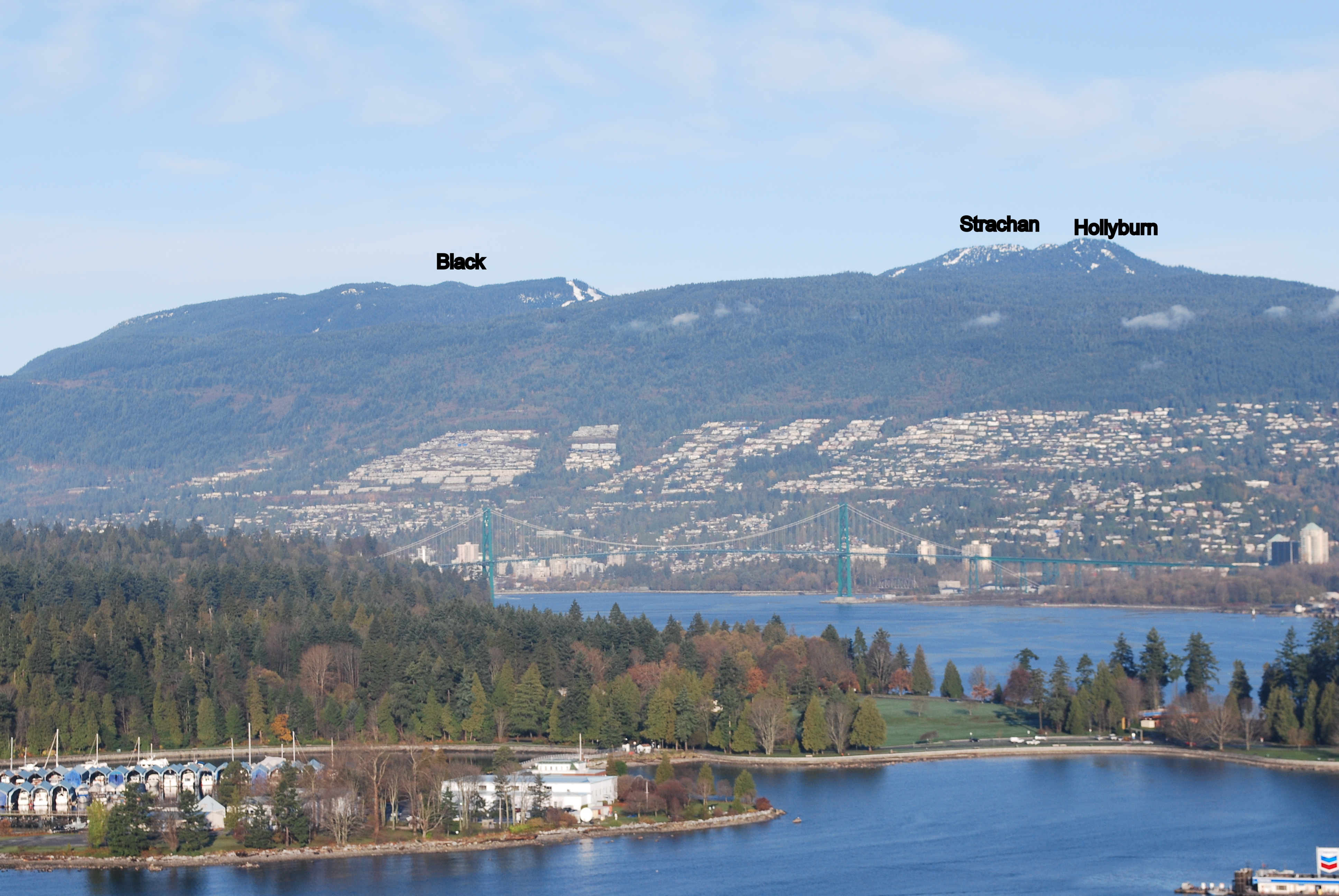
SPRING BAGS:in addition to the Howe Sound Island peaks, we've opened up the "front row" of more easily-accessible peaks to the April starting date, for anyone who wants to try a snowshoe bag. ONLY TRY IN CLEAR WEATHER and ALWAYS CHECK THE AVALANCHE REPORTS and BRING THE PROPER EQUIPMENT and BE CAUTIOUS!: BLA, HOL, STR, GRO, DAM, FRO, SLY, LYN, SEY, SUI, DEP (NOT GOA, which has a nasty sheer drop which has claimed several lives in the winter).
WINNING TIE-BREAKER MECHANISM: In the case of a tie for first place:
1. the bagger with the most starbags (i.e. 1. water bags (i.e. peaks ascended from sea level to peak: see below) 2. true bags (i.e. true summits of GOT and CRO), 3. gift bags (i.e. trail work)) will win;
2. if still a tie, the bagger with the most unique bags (i.e. peaks that no one else visited) will win;
3. if still a tie, the bagger with the most write-ups and comments posted on the CFA Flickr website will win;
4. if still a tie, the bagger with the most photos posted on the CFA Flickr website will win;
5. if still a tie, the bagger with the most obscure/difficult bags (at the completely arbitrary discretion of the host) will win.
PRIZES: The winner will be the proud bearer of the CFA Bagger Munro Quaich cup for the year: the appropriate cup from which to drink a winter whisky and contemplate how awesome you are. There will be an auxiliary prize for the person who draws the most other people into the cult of peak-bagging. For other prizes, see below.
BAGGERS' BANQUET: To cap off the bagging season, we will either have a get-together at a pub, or else a barbeque for all bagger participants and their significant others. The Bagger Quaich will be awarded.
Date: Friday, October 25, 2013. 6pm - 10pm.
Place: t.b.a.
NO SANDBAGGING: all claims to bagging a peak must be submitted as promptly as possible (in most cases, within 3 days) of the actual climb. Climbs of more than two weeks old will be stale-dated for baggers already in the contest. Old bags by new baggers will be considered on a case-by-case fairness basis at the sole discretion of the administrator: late bags by new baggers late in the season will likely not be counted.
ARCHIVES
2012 Munro Quaich: Bill Maurer: 57 (i.e. ALL) peaks
2012 Pippa Quaich: Carolyn King: 21 peaks
2012 Harry Quaich: Harry Crerar: 15 peaks
2012 Tundra Quaich: Tundra the Ultra Dog: 18 peaks
2012 Twisted Quaich: Team Dagg and Team Healey-Thorpe
ENTRY: There is no fee and you don't need to be a member of Club Fat Ass to participate in a Flash event, however whining is not allowed. That being said, many of the peaks listed should only be attempted by those with the experience and fitness level of a typical Club Fat Ass member (i.e. ample mountain running experience over long distances).
IMPORTANT SAFETY CONSIDERATIONS: All of these adventures are potentially dangerous.
You are responsible for your own well being and safety and should be self sufficient.
Here are two useful lists of "MUST HAVE" survival items that all participants should carry:
Mountains marked with a !!! are scramble ascents or otherwise exposed or otherwise remote and undeveloped and should only be attempted by experienced climbers wearing helmets, etc. Don't try these routes in anything but perfect weather.
Use great caution when rocks are wet -- slipping is the cause of most accidents on North Shore mountains.
Always run/hike with a buddy.
CFA reserves the right to remove anyone from the Challenge for doing reckless, dangerous, destructive, or foolish actions.
PARTICIPATE AT YOUR OWN RISK: YOU ARE WAIVING LEGAL ACTION: By participating in this event you agree to be wholly responsible for your own well-being and agree not to sue anyone associated with this event or Club Fat Ass or any person in relation to this activity. By participating in this event you agree to the terms of the Release of All Claims.
THE 59 NORTH SHORE PEAKS (ranges from west to east)
Altitude listed first, in brackets (metres)
# = Top-12 highest peak
P= Prominence (distance one must first descend before climbing next peak)
[[[ = NOT AN OFFICIAL PEAK in the Bagger Challenge, due to real exposure. Should only be attempted by experienced and competent alpinists. Attaining one of these peaks will nonetheless count as a bagger point.]]]
Peak notes (in round brackets at end)
peaks in italics indicate those baggable from April 1st.
for greater certainty peak ("pk") location among several possible summits (North,South, East, West)
*** as the true peaks are semi-exposed, and there is a false summit very close, attaining the false peak will get you the point, and attaining the true peak will be starred and count as a starbag (i.e. a tie-breaker).
e.g. the proper peak of Crown is a hair-raising wedge of rock with an impressive drop on 3/4 sides; attaining the (unscary) platform just below this true summit will get you a point).
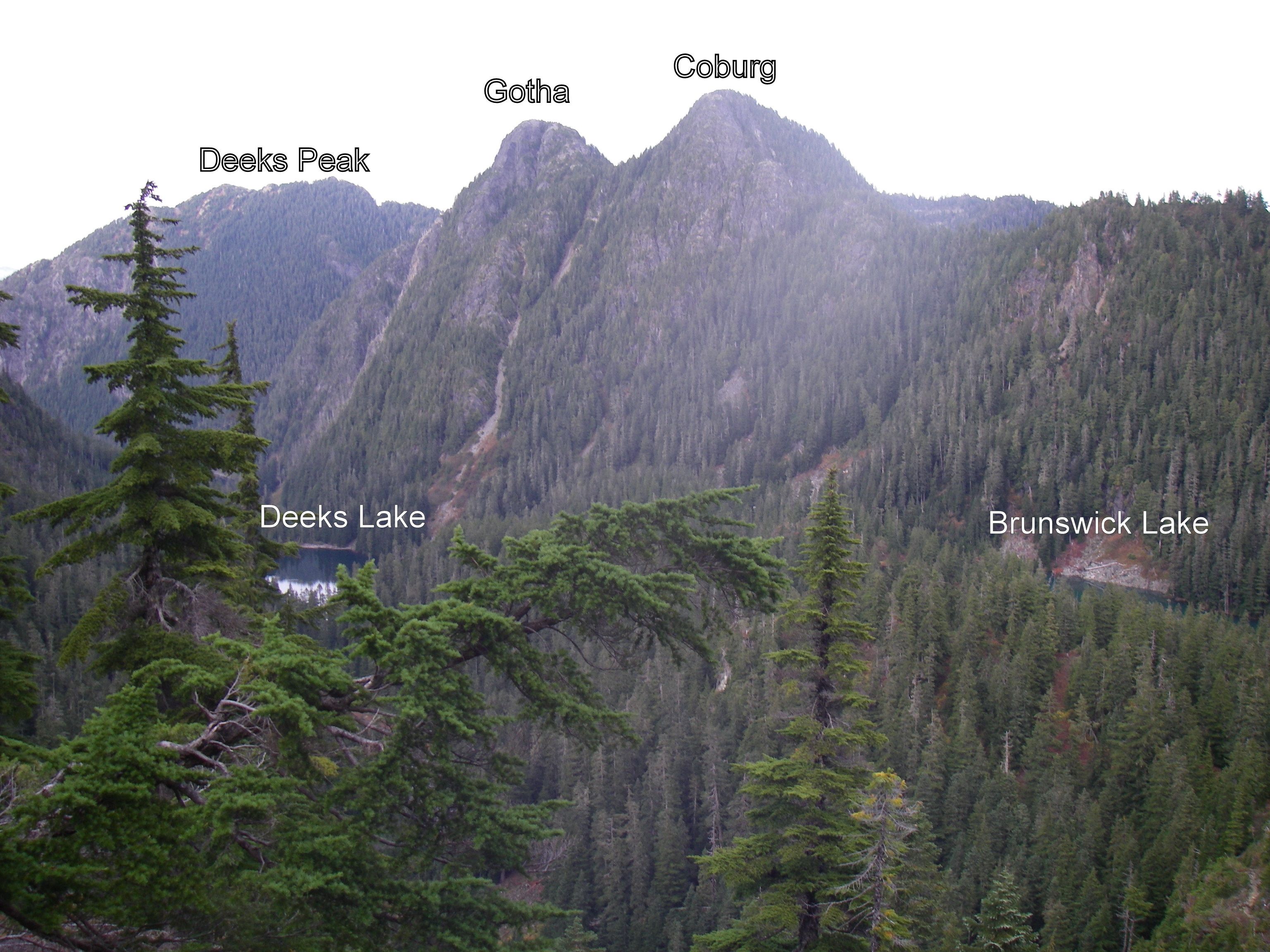
e.g.2 the proper peak of Gotha is the south peak, which is a semi-hair-raising traverse above a semi-sheer drop into Deaks Lakes way below; attaining the northern peak, with nearly identical height, will get you a point.
Resources and hyperlinks
103 = Bryceland & Macaree, 103 Hikes in Southwest British Columbia
MG = Matt Gunn, Scrambles in Southwest British Columbia
DH = Dawn Hanna, Best Hikes and Walks of Southwestern British Columbia
12= trip reports and maps
AB= peak photos
Note: the links to trip reports won't work unless your page is set to "50 comments per page" (the default setting)
Difficulty and Quality Rating {purple; in fancy brackets}
Difficulty: Hard; medium; easy
K = best hikes for kids
!!! = Dangerous: exposed or real risk of falling rock
!!!!!!!!! = Very dangerous; experienced mountaineers only
&& = trail at times faint or nonexistent; need route-finding skills
Quality: 1-5, with 1 being the best and 5 the worst
For a guided tour of the Bagger Peaks on Google Earth please click download the file attached below and open with Google Earth (and try the 3D flight simulator option under "tools"!)
For a full size Bagger map click on the image below:
Map by David Crerar; kindly and capably updated by Richard Macdonald
Submitted by kmoeller on 3 September, 2013 - 12:01.
Did SEY this weekend. The plan was to make a long day of it and do elsay and runner's peak as well but when I got to the top I decided to take a long nap in the sun instead. Sometimes that's the preferable option.
And is it too late for me to report on doing COL? Bagged that one as a long, foggy hike with a couple friends a few weeks ago.
Submitted by Eric Rannaud on 2 September, 2013 - 22:14.
My wife Jessica and I bagged Suicide Bluff on Saturday, coming back via Dog (steaming heap? That's no mountain). The trail to SUI on the north side of the loop is very nice; the trail from Dog to the parking lot less so.
I didn't expect such a nice view of Downtown from the bluff. Worth it.
Submitted by Ean Jackson on 2 September, 2013 - 09:07.
Nine (9) hours at a leisurely pace via the Hanes Valley for Carlie Smith, Jason Cagampan, Jim Swadling and Ean Jackson.
Some highlights:
it was a bluebird day (Sat 31 Aug)
ran to the Hanes saddle with a larger group who were doing Go Home Via the Hanes Valley (thx, Des!) and saw several other trail running pals en route
our yodels at the top of Crown Mountain received responses. Suspect it was bagger buddies on Crown N1
could not find traces of the dead guy I found on Crown a few years back
did not want to end up like dead guy, so opted-out of trying to get to Crown N1 from Crown
picked up some trash (note to Des!). Other "ground scores" included: a black, size L cotton t-shirt with a North Vancouver logo, a birthday balloon, a condom (as new, in wrapper) and several choice mushrooms
lotsa lovely alpine blueberries to supplement our gels and trail mix
just about stepped on a grouse. saw 2 large grizzly bears
tough call: Get car for sure or go for a pint and miss the 7:00 pm posted closing at the Lynn Headwaters parking lot. Not yet sure if Jim got his car out in time?
Some general guidelines to those who may want to follow this route:
it took us 2 hours to get from Lynn Headwaters parking lot to the heli pad in the Hanes. Another hour to get to the Hanes saddle. Another 4 hours to bag Crown, West Crown and get back to the saddle. Two hours more from saddle to getting onto the Skyride including baggage (Goat, Little Goat) and a cool beer on the outdoor patio.
leisurely pace, experienced group, lotsa photos, we didn't get lost, wonderful weather.
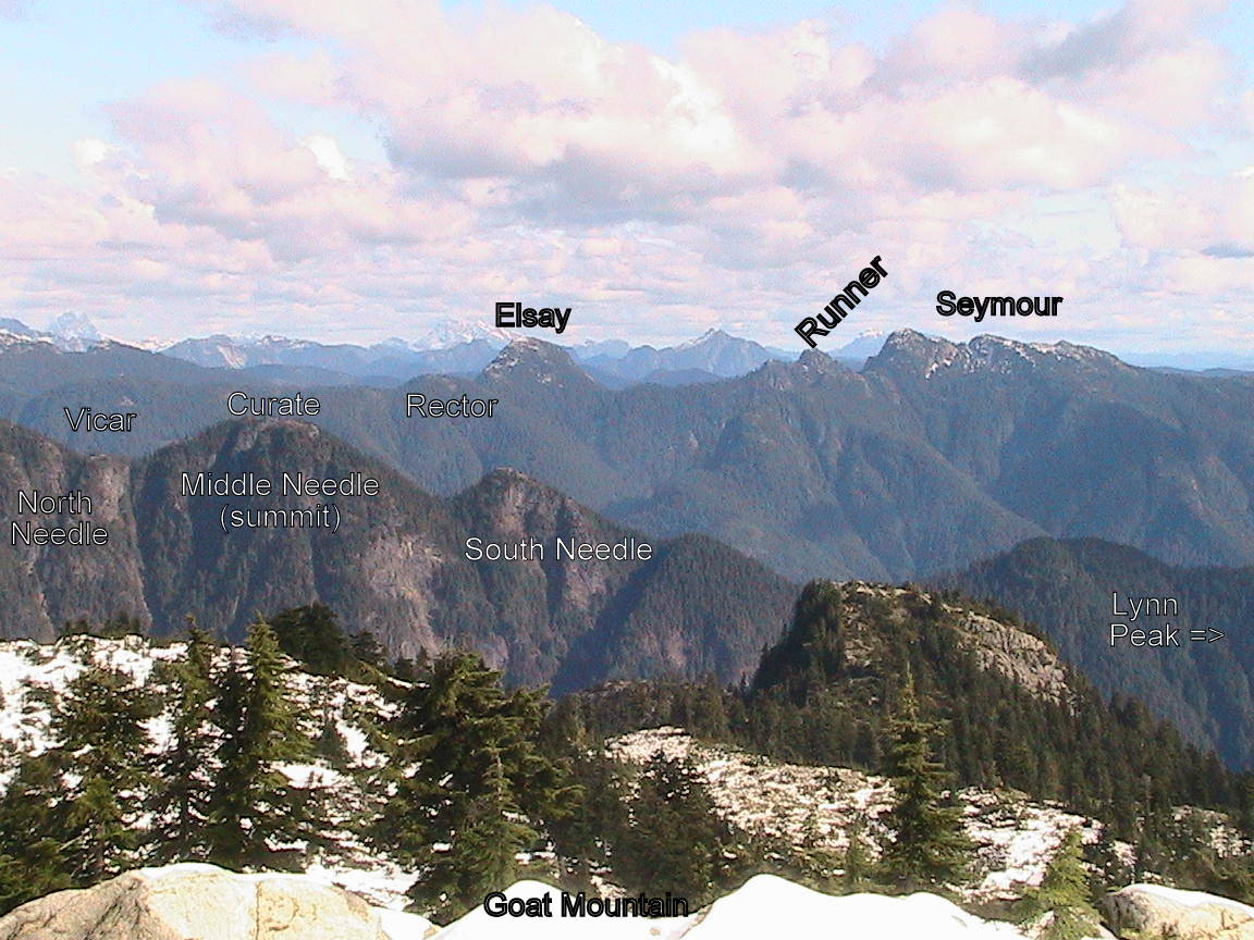
I bagged Seymour, Runner, and Elsay during a short overnight trip. I left the Seymour parking lot around 4:30 yesterday afternoon. Followed the usual route up to Seymour, then double backed a bit and headed down the Rector / Vicar / Curate trail toward Runner. Made my way up the snow and boulder field to the saddle between Runner and Seymour. Then I quickly scrambled up and down Runner in the rapidly diminishing light. I ate dinner in the saddle between Runner and Seymour as the last bit of light faded. Then I hung my food from a cliff and set up camp in the dark. There isn't much flat ground in the area, but I found a spot that was just big enough for my bivy. It wasn't very comfortable, but it worked.
I woke up the next morning at 6:30am, retrieved my food, ate breakfast, broke camp, and was back on the trail by 7:30. I got to the Elsay summit at 9:30.
I had hoped to continue on all the way to Vicar, but I'm still recovering from a bruised heel, and it was starting to bother me, so I decided to cut it short. I followed the other Mt. Elsay route down to the Elsay Lake trail. It descends a large boulder field below the South face of Mt Elsay. I had to take it annoyingly slow to avoid any impact to my heel. There's a nice creek to drink from near the bottom. Shortly after the creek, I came to the Elsay Lake trail. From there, it is an easy, if slightly long, walk back to the Seymour parking lot.
Yikes, where did the summer go, I haven't been on here or bagged a peak until TODAY and it sort of doesn't even count 'cause they were just little side-trips off "Go Home Via Hanes Valley". But, I'll take 'em!
LIL & GOA please, Bag-man.
We do have a family diaper-bag planned for tomorrow afternoon, hopefully the weather stays lovely! Enjoy, everybody. Happy Bagging!
The blazing of a new BP - Sunset connector trail called my name today, and now allows to complete an awesome loop around Black mountain.
Started at the KneeKnacker start line, but very quickly left the race's route to cross the Nelson creek road bridge and up north along an un-named trail (with lots of interesting Arbutus trees) that roughly parallels Whyte lake trail to the west.
Re-connected with BP at Whyte lake, but left it again at elevation ~500m into a brand new connector trail heading north and naturally traverses that 500m contour line across 3 creeks and old growth, until it meets Sunset trail at the same 500m elevation (thank you again oldmatt!).
Up the peacefull Sunset trail and its spectecular viewpoint to Yew lake, re-connect with BP and up its switchbacks to bag Black's northern summit. Then a short down to Cabin lake for the first - and coldest - swim of the day.
Headed SW along BP, and took a right after the last lake to the Donut bluffs trail and the bluffs' viewpoint.
My intention was to continue down along this trail, but after spending 15 minutes trying to find a continuation of it past the bluffs, as the map sez, I gave up on the blowdowns and returned to Eagle Bluffs, and down BP to Whyte lake and the second swim of the day in perfect water.
Chose to return to the start via the same un-named trail I came up on instead of using Whyte lake trail, and it made for a quick & quiet downhill return. A nice way to spend a sunny Saturday morning.
last weekend i did hanes valley with a little extra fun thrown in for good measure. i left plenty of blueberries for you guys doing hanes this weekend but i regret to inform you that i made short work of all the sweet, delicious salmon berries. here i am on crown:
i took a nice tumble on bp on my way back to lynn and split my knee open real nice. but at least i made it back just in the nick of time to do the capilano night run!
Submitted by Ean Jackson on 29 August, 2013 - 08:17.
Yikes... the end of summer is nigh!
I'd like to do something useful with my life during what's shaping-up to be a wonderful patch of weather between monsoons this rapidly-approaching Labor Day long weekend. Maybe you would, too?
The Plan:
Saturday 31 August
start the "Go Home Via the Hanes Valley" with what's shaping-up to be a great group of folks. This would mean being at Lynn Headwaters parking lot by about 8:20 and coordinating with a car at the base of Grouse Mountain www.clubfatass.com/events/gohome
at the saddle at the top of the Hanes Valley, head right. Bag Crown N1, Crown and possibly West Crown before heading in the direction of the nearest pub. En route, bag at least one Goat, Dam and Grouse, eat a bunch of alpine blueberries, check for mushrooms, ride a bear or 2, breathe a lot of pine-filtered rarefied air, share some stories and enjoy some of the best of beautiful BC
celebrate with a cool one and a plate of nachos (extra sour cream and guaca) on the deck at Altitudes Bistro before heading home and eating some more
This could end-up being a long day. It would certainly be memorable.
If interested, pls leave a reply here and we can figure out the details.
...but do you reckon your old joints are up to it, Jackson?
I guess if you can do it then I should try. We can always take turns at carrying each other.
Submitted by Ean Jackson on 27 August, 2013 - 10:02.
Word has it the route is somewhat mysterious, definitely enchanting. I'd love to find out. Anyone interested in joining me one fine, sunny day?
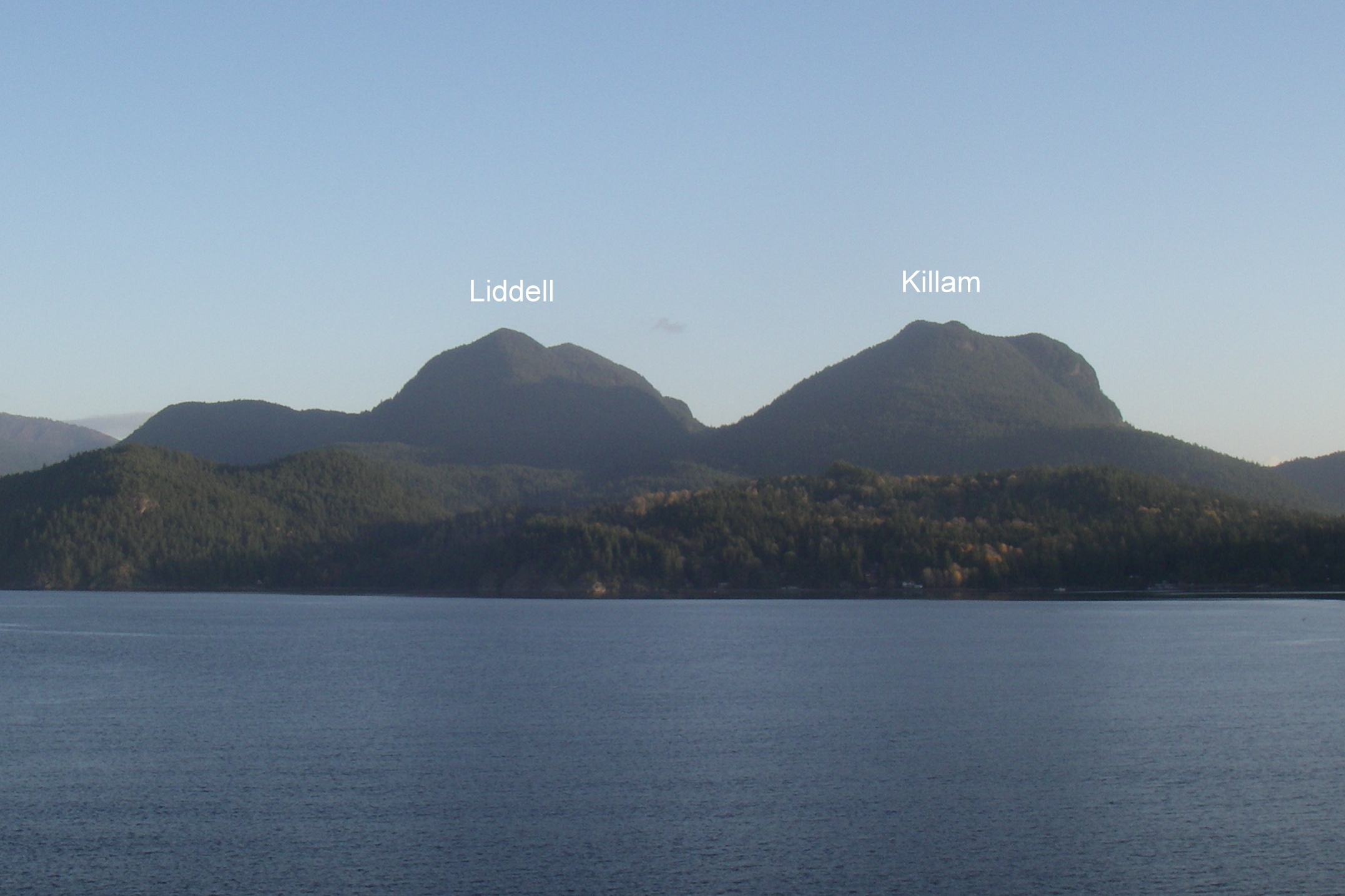
I also have some unfinished business to take care of on Gambier Island. 'Was thinking of paying respects to Liddell and maybe Burt's with some flagging tape and pruning shears.
If our availabilities line up I'd be down for some Enchanting. I just had my first taste of the northern parts of the HSCT and I'm itching to get back. Keep me posted, Thursdays, Fridays and Sundays work best for me.
I bruised my heel playing ultimate a couple of weeks ago, and I hadn't been on the trails since. It's still not completely healed, but I couldn't sit around any longer. I didn't want to put too much stress on my heel, so I biked from Kits up to the Cypress parking lot, and then carefully ran up Hollyburn. Got a nice view of the sunset during the ride back down. Put me down for HOL, a waterbag if using a bicycle is allowed.
Submitted by Bill Dagg on 22 August, 2013 - 10:13.
Anyone interested in joining me for some bagging this Sunday?
I'm thinking of 2 options:
1) A partial loop on Seymour via the Elsay Lake trail up to 3 peaks: Elsay; Runner; Seymour (~ 20 km) 2) A long out and back (30 - 35 km) to Coliseum and Burwell.
The first option is somewhat shorter and will have a mix of running and scrambling. The second option will be mostly running but is a lot longer distance and somewhat longer time.
You can email me directly at bill.dagg@shaw.ca or give me a call at 778.835.6848.
Submitted by Bill Dagg on 19 August, 2013 - 21:46.
... and, with Dog Mountain, is a blueberry feast! Jess and I took advantage of Jess's last flex day and headed up to Suicide Bluffs by way of Dog Mountain. The weather wasn't perfect (it got a little misty by the time we got to Suicide) but held off for the most part and offered some views on a somewhat chilly day for mid-August. Nevertheless it was an enjoyable little adventure just over 1:45 including stops for photos and a fair amount of time feasting on the now ripe and abundant blueberries (particularly on the western slope of the Dog Mountain bluff).
Submitted by clarkee76 on 18 August, 2013 - 14:19.
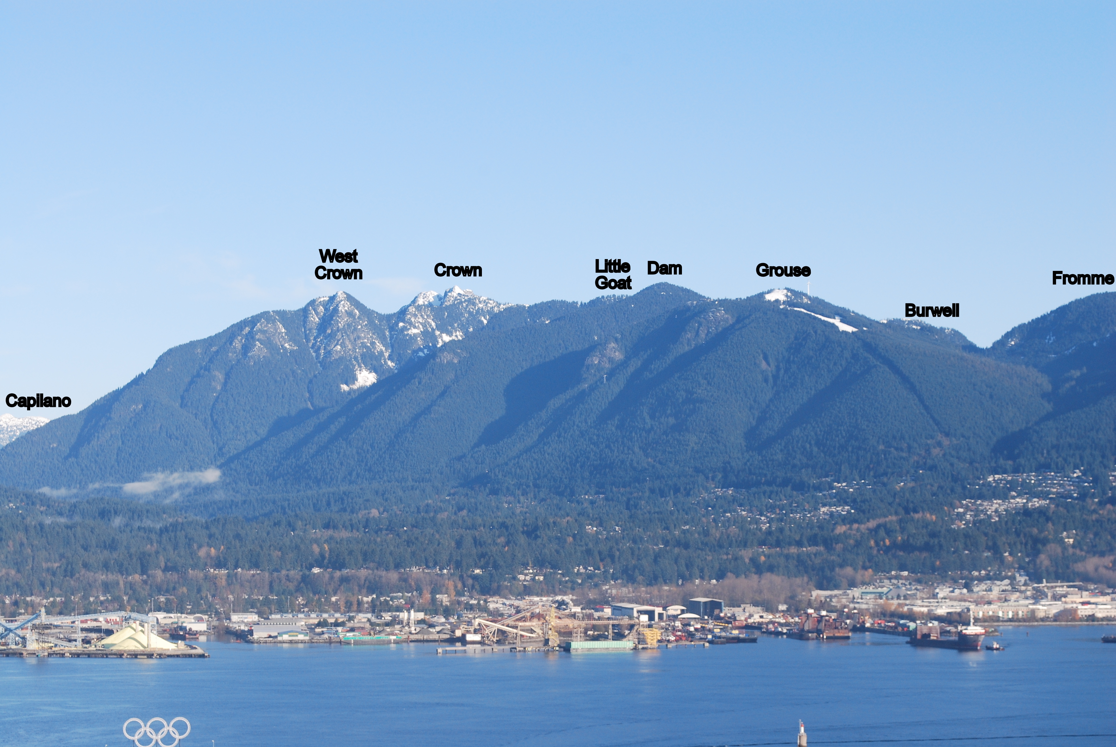
So anyway this years bagging season has been quite succesful by my own low standards and I was looking forward on make an attempt on Dam and Little Goat by way of Dreamweaver and the Eric the Red trail, thereby sneaking Stetson in round the back of Grouse Mountain.
As we ran up Dreamweaver the urge to explore got the better of me we headed across Mosquito Creek and up to the Lower Grouse Mountain Highway to the little connector trail between the two grouse roads. This was a little more challanging than expected (you know you are having a good time when you see North Shore Rescue flagging tape) but thats a story for another day. Once at the col between Grouse and Fromme we headed off along Pipeline / Erik The Red which was great but very steep once across the small rockfield. Around this time the pissing rain began and Pertex jacket failed within seconds but that was not a surprise and we pressed on to the small open area where the trail splits in my wisdom / cold / summit fever I elected to go right which was very nice but clearly not a peak, a quick check on the map and it was confirm to be Thunderbird Ridge.
Looking at my watch and weather we decided to head for home rather than any kind of qualifying peak and there the fun began, fell three times on the descent and did an impressive job on my ankle (medicinal beer has been applied and it is much better) and lost my watch before making at back to the safety of the mountain highway and the Fromme mountain bike trails.
So please Chief Bagger put Stetson and James down for nothing. We shall be back with more focus, better weather and about 1 hours more time soon....
Submitted by clarkee76 on 8 September, 2013 - 20:05.
So anyway three weeks after disappointment, displaced watches and nearly dislocated ankles we returned....
Stetson and I set of from the Dempsey Bramear trail head and head up St Mary's, Dream Weaver, Per Gynt, Mountain Highway, Pipeline Pass, Erik the Red, Thunderbird Ridge and Alpine Trail to Dam Mountain. We arrived there in a little under two hours (much to the surprise of the picnicing hikers) at a Clif bar turned around and was back at the car 90 minutes later. Nothing lost nothing gained except a small handful of blue berriers.
Please can you put Stetson and I down for DAM. Cheers
I had booked the guided bag with James and Stetson the Mountain Hound today. Runner (who came up with that name ... Scrambler would be more appropriate) and Elsay were our objective. James had been up this route before and was therefore the designated tour guide.
There were high clouds and it was spitting rain a couple of times, but overall we had great conditions for the mission. Well ok, there was some thunder rumbling in the distance at one point, which had us survey the sky and wonder if we should leave the bagging of Elsay for another day. We didn't and everything worked out great. The very top section to Runner peak is quite the scramble, but beside that it's all good old North Shore hiking punctuated by some running where possible. The trip took about 5 1/2 hours with just a couple of short snack breaks.
Just below Runner's Peak. James and Stetson looking pretty relaxed.
Peak of Mt Elsay.
Even I was able to spot this Geocache in the cairn on Mt Elsay.
Please put James and Marc down for RUN and ELS and Stetson the Mountain Hound for ELS
I will be starting at 3pm at the Gazebo.
I am planning to go up hydraulic and come down the Lynn peak trail.
I am budgeting about 5 hours for the loop so we can finish while it's still light out.
Please contact me directly if you'd like to join.
Marc
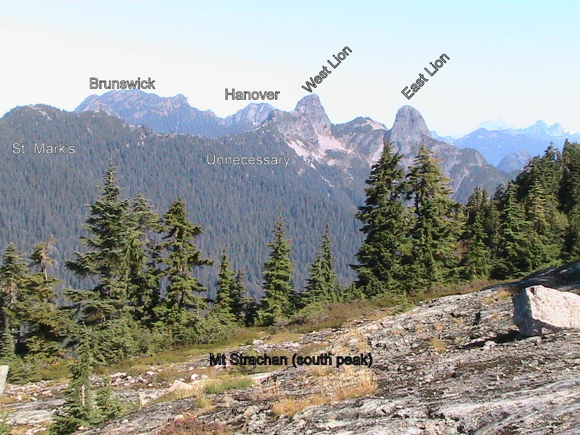
I am organizing a sweep of the Brunswick area this Saturday August 10th.
It will cover the 5 summits of Brunswick, Hanover, Fat Ass, Hat, and Wettin over a 29km loop that's never been done before in a single day. A large part of this trip is spent in the alpine.
If interested and for more details sign up here: http://www.meetup.com/BC-Outdoor-Adventures/events/133873392/.
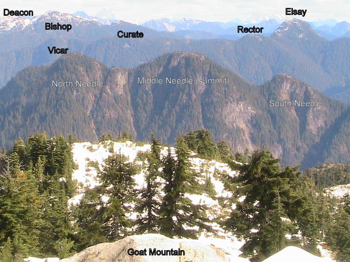
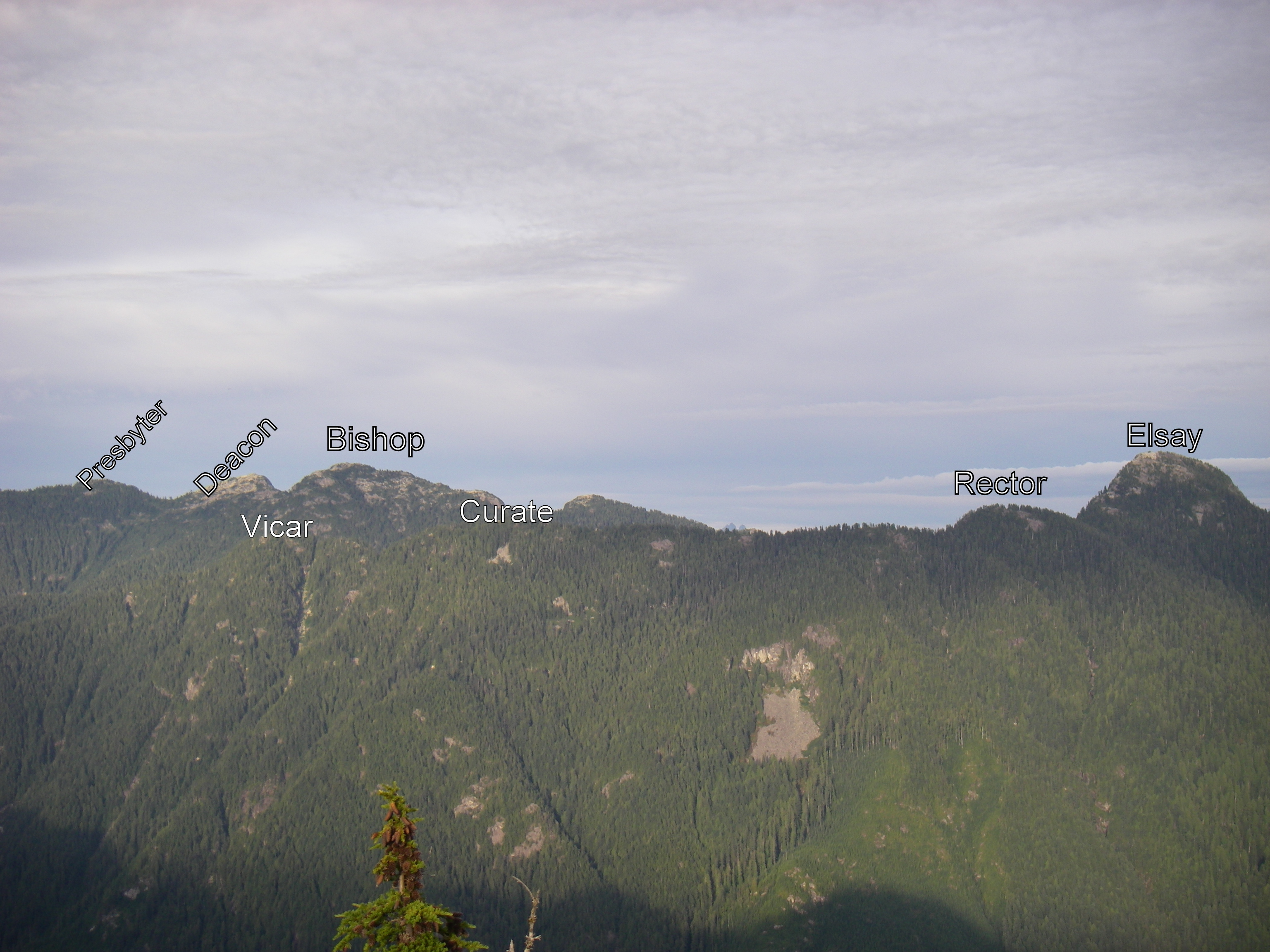
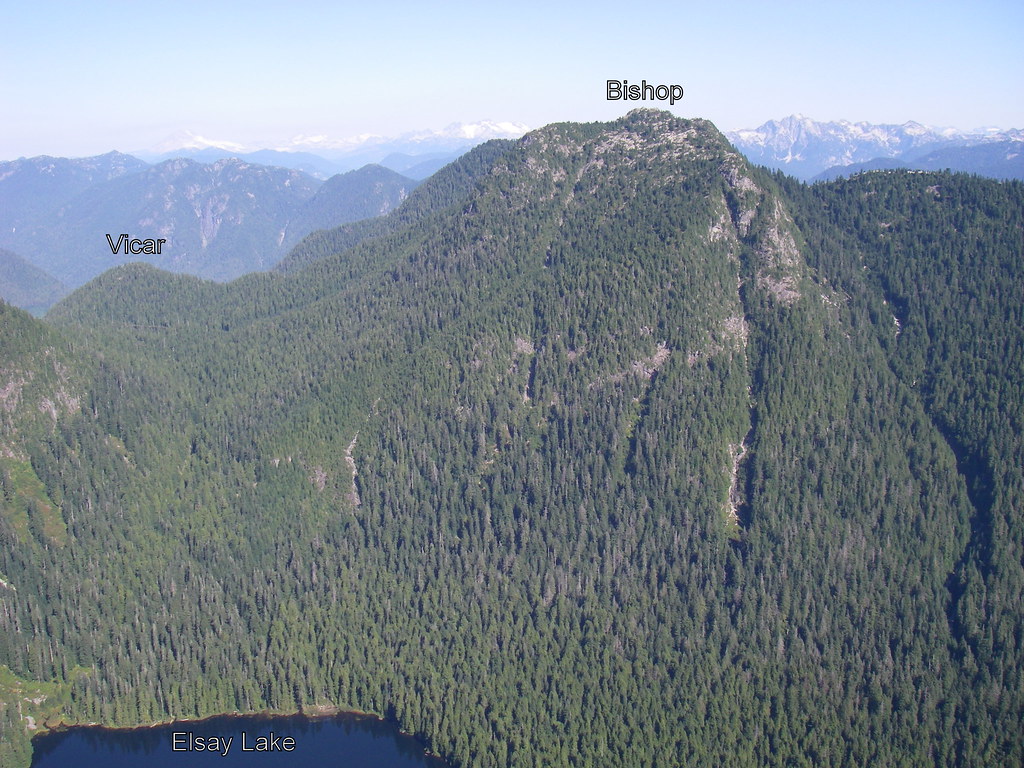
Bagged Bishop (BIS) on Monday. Biked up the LSCR road to the trail leading up to Vicar Lake and Mt Bishop. Stashed the bikes at the trailhead. The trail from the valley to Vicar Lakes is steep with many ropes to help along the way. Lots of bugs around the lake, so we didn't linger.
The trail is less steep from Vicar Lake to the summit. There are some patches of snow and streams of meltwater just below the summit.
View from the summit facing East.
The whole trip took 5.5 hours with about 1 hour of biking. We ran a little during the descent.
What's a tapering bagger to do on a sunny Sunday?
An aesthetic west to east loop of the 2 Seymour bluffs, with only a couple of road crossings.
Park & start at the "Vancouver Picnic Area", about half way up the Seymour access road at elevation 560m.
Head N on Enquist trail, then W and down Run Lola Run for a bit, turn NE again on a loamy Magic Kingdom, crossing Enquist, and continuing up Magic Kingdom which now turns into blow-down galore, steeply carving its way up the mountain until it spits you out near the Seymour ski area, at the works-yard.
Cross the road, head north on the trail behind the various Seymour huts, and get to the Dog Mt trailhead.
Visit the Dog Mt bluffs, and continue NE on Suicide bluffs trail to the bluffs viewpoint, then bag the bluffs themselves.
Unfortunately, the whole area was under cloud cover, affording zero views.
The Suicide bluffs trail ends at the Mt. Seymour main trail - Loop N of Mystery Peak, then take the trail heading NE under the base of the Brockton chair, and head up to bag DePencier bluffs, again under complete cloud cover.
Time to go downhill, but the hard way! The Perimeter trail heads S and down, but it's slow going - Overgrown with Salal, underbrush, and wet & slippery rocks/roots from yesterday's rain, one has to take it slowly down the mountain, staying in focus not to miss a couple of sneaky left turns.
At the Goldie Lake turn-off the going gets easier, as I soon join Old Buck and sprint down it to head back via a connector trail to the picnic site where I started.
I wouldn't recommend using upper Magic Kingdom (blow downs, route finding) or Upper Perimeter (overgrown, tricky junctions) at this time, unless you know what you're doing. For experienced baggers, tapering or not, this is a beatiful loop.
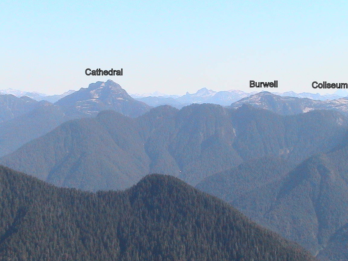
Paul, Spencer and I set out to Conquer Paton, Coliseum and Burwell today. We decided to bike the 9.5 km on the LSCR road to the trailhead, which was still nice and quiet in the morning. After stashing the bikes we started ascending the steep, but exceptionally well marked trail up to Paton. We were able to get some nice partial views on the way up, however we were in the clouds on the actual peak. On to Coliseum then. The Route was still well flagged all the way up to the summit. On the way there we got all excited when the Haze burned off and we were rewarded with stunning views all around. Just enough clouds lingered to provide some nice accents among the surrounding peaks. On to Burwell. The flagging became less, but between some common sense, some cairns and some tape the journey to the peak was easy enough.
Then we had an idea which would in the end turn a 12k trip into 32k (excluding the biking).
A member of our group (who chooses to remain annonymous) thought "Wouldn't it be nice to get some running in after all this scrambling and hiking?!" So we decided to descend down towards Norvan Falls. Run the Headwaters Trail and then the LSCR road to retrieve the bikes (Which we wouldn't have needed if we knew we'd do the entire loop).
We even did an extra loop around Rice Lake for reasons none of us fully comprehends.
We clocked in at 7h 30min on our feet in the end which worked out to about 8h 45min including the bike ride and the transitioning between disciplines.
I can't speak for the other two guys, but I'm pretty fried tonight.
Please put Paul, Spencer and Marc down for PAT COL BUR
Submitted by David Crerar on 1 August, 2013 - 14:40.
PHOTOS: Please post your photos, too. Add to the CFA Flickr Pool (instructions here. It's easy!), tag your photos: ClubFatAss ClubFatAssEvents ClubFatAssEvents2013 BaggerChallenge2013 BaggerChallenge (with a space separating each tag on the flickr template)
So anyway needing a change of scene and focus I arrived at the Cypress Parking Lot at 7.10, unleashed the mountain hound who promptly ran off in the wrong direction (twice). Once he was retrieved and refocused we hit the BP to the Old Stachan Trail then branched off to Hollyburn where the mountain hound got himself cliffed out. Once that was resolved we pushed up to the deserted Hollyburn Peak before dropping back to climb Strachan. Fantasic run across the south summit in golden sunlight before a quick down up to gain the north summit, admired the view in light breeze (no bugs) and watch the sun dip close to the Sunshine coast before heading down Chrstmas gully, trail was soon lost and a more radical descent route was taken, no further cowardice was shown from the mountain hound and we arrived at the junction with the HSCT at 9.10, a quick burn along the HSCT and down a ski run and we were back at the car at 9.30.
Please put James and Stetson down for HOL and STR (at the fourth attempt)
I was thinking about South Lynn, Lynn and South Needle or maybe Paton, Coliseum and Burwell (which would involve some biking), but I am flexible if you want to suggest another mission.
Let's meet at the Gazebo at 8am on Sun the 4th then. Hope that works and if people want to joins us they'd be welcome. I am not sure if we'll manage Burwell too. I havn't been out that way before.
Just to make sure everybody is on the same page. We'll be going out on the bikes before climbing up Paton.
I'll prepare for a five hour kinda outing I guess?


Comments
COL and SEY
Did SEY this weekend. The plan was to make a long day of it and do elsay and runner's peak as well but when I got to the top I decided to take a long nap in the sun instead. Sometimes that's the preferable option.
And is it too late for me to report on doing COL? Bagged that one as a long, foggy hike with a couple friends a few weeks ago.
SUI
My wife Jessica and I bagged Suicide Bluff on Saturday, coming back via Dog (steaming heap? That's no mountain). The trail to SUI on the north side of the loop is very nice; the trail from Dog to the parking lot less so.
I didn't expect such a nice view of Downtown from the bluff. Worth it.
CRO, WCR, GOA, LIL, DAM
Nine (9) hours at a leisurely pace via the Hanes Valley for Carlie Smith, Jason Cagampan, Jim Swadling and Ean Jackson.
Some highlights:
Some general guidelines to those who may want to follow this route:
Grizzlies as in Grinder and
Grizzlies as in Grinder and Koola ;-) in their natual fenced habitat....hahaha
trash shirt
I saw that shirt when I did Hanes last weekend . . . it was crumpled up on the ground and sopping wet so I hung it up on a bush to dry out.
Mudslide
I think the bush was trashed in a mudslide after the monsoons last Thursday. Happy to hear the owner of the shirt was not buried.
beautiful spot
Seymour, Runner, and Elsay
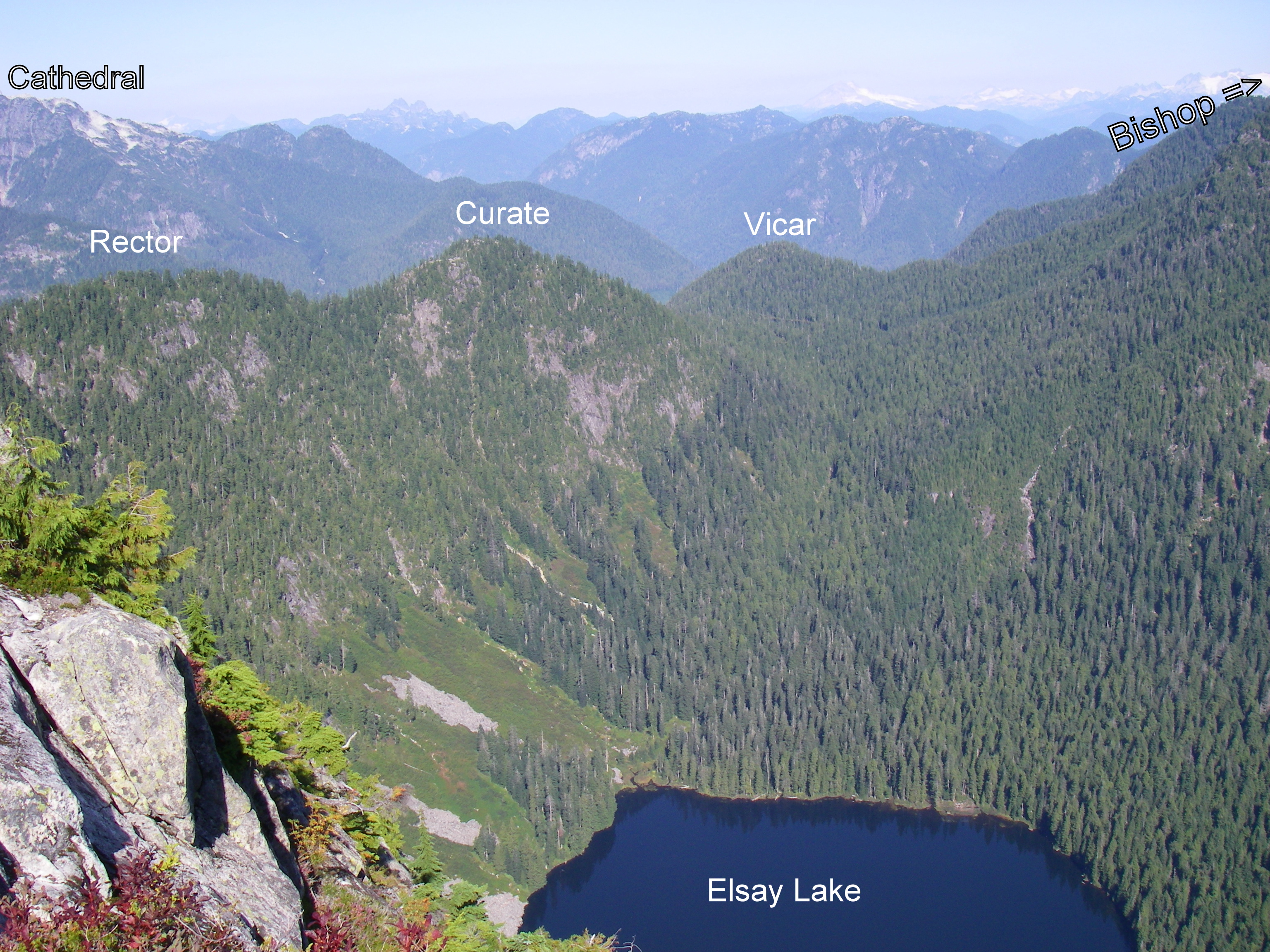
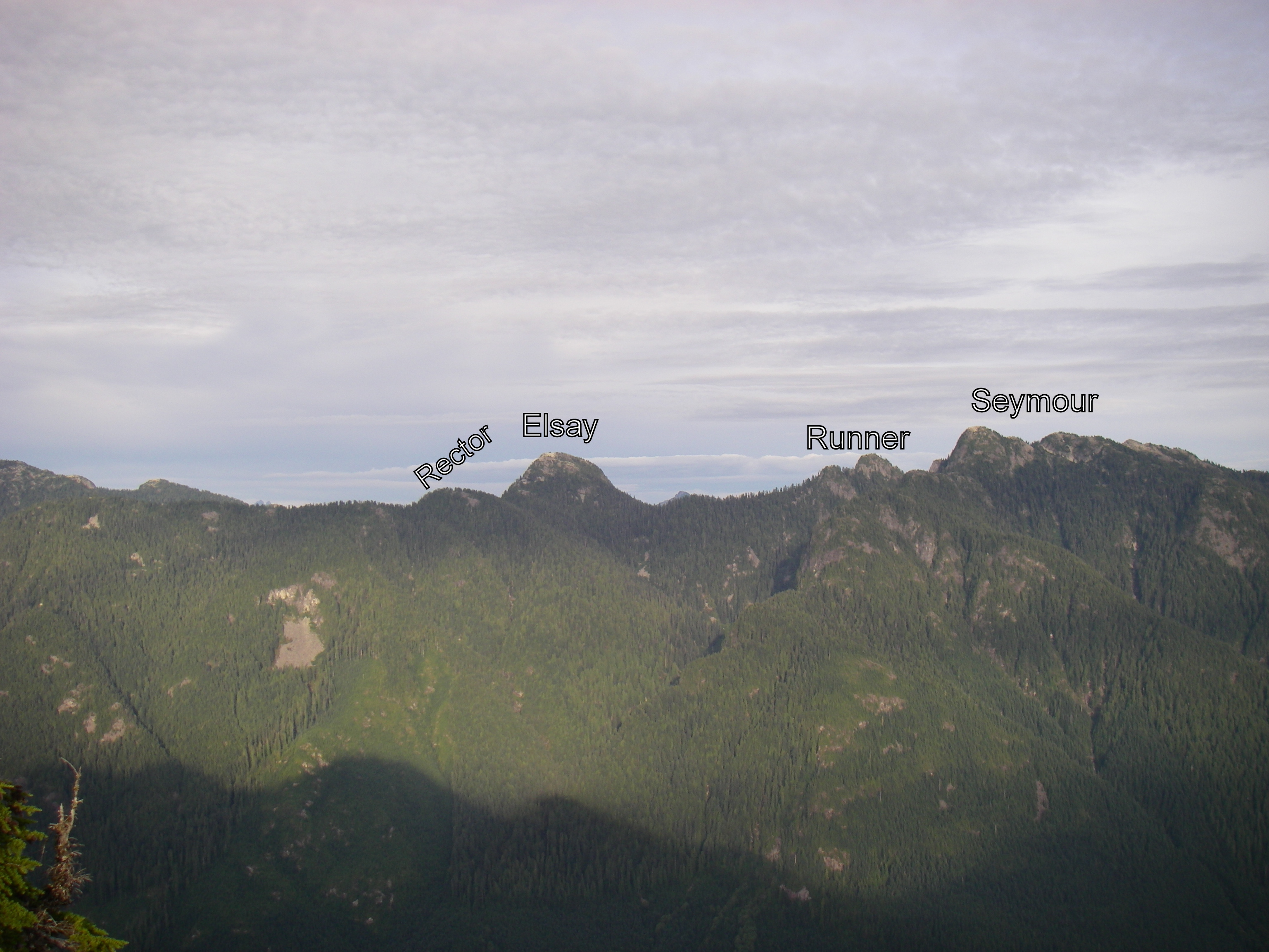
I bagged Seymour, Runner, and Elsay during a short overnight trip. I left the Seymour parking lot around 4:30 yesterday afternoon. Followed the usual route up to Seymour, then double backed a bit and headed down the Rector / Vicar / Curate trail toward Runner. Made my way up the snow and boulder field to the saddle between Runner and Seymour. Then I quickly scrambled up and down Runner in the rapidly diminishing light. I ate dinner in the saddle between Runner and Seymour as the last bit of light faded. Then I hung my food from a cliff and set up camp in the dark. There isn't much flat ground in the area, but I found a spot that was just big enough for my bivy. It wasn't very comfortable, but it worked.
I woke up the next morning at 6:30am, retrieved my food, ate breakfast, broke camp, and was back on the trail by 7:30. I got to the Elsay summit at 9:30.
I had hoped to continue on all the way to Vicar, but I'm still recovering from a bruised heel, and it was starting to bother me, so I decided to cut it short. I followed the other Mt. Elsay route down to the Elsay Lake trail. It descends a large boulder field below the South face of Mt Elsay. I had to take it annoyingly slow to avoid any impact to my heel. There's a nice creek to drink from near the bottom. Shortly after the creek, I came to the Elsay Lake trail. From there, it is an easy, if slightly long, walk back to the Seymour parking lot.
Camp in the morning:
Near Elsay summit
Guess the Peak
... we just bagged
Guess the Peak
... I just bagged
finally bagged something!
Yikes, where did the summer go, I haven't been on here or bagged a peak until TODAY and it sort of doesn't even count 'cause they were just little side-trips off "Go Home Via Hanes Valley". But, I'll take 'em!
LIL & GOA please, Bag-man.
We do have a family diaper-bag planned for tomorrow afternoon, hopefully the weather stays lovely! Enjoy, everybody. Happy Bagging!
Loop is the new Black
The blazing of a new BP - Sunset connector trail called my name today, and now allows to complete an awesome loop around Black mountain.
Started at the KneeKnacker start line, but very quickly left the race's route to cross the Nelson creek road bridge and up north along an un-named trail (with lots of interesting Arbutus trees) that roughly parallels Whyte lake trail to the west.
Re-connected with BP at Whyte lake, but left it again at elevation ~500m into a brand new connector trail heading north and naturally traverses that 500m contour line across 3 creeks and old growth, until it meets Sunset trail at the same 500m elevation (thank you again oldmatt!).
Up the peacefull Sunset trail and its spectecular viewpoint to Yew lake, re-connect with BP and up its switchbacks to bag Black's northern summit. Then a short down to Cabin lake for the first - and coldest - swim of the day.
Headed SW along BP, and took a right after the last lake to the Donut bluffs trail and the bluffs' viewpoint.
My intention was to continue down along this trail, but after spending 15 minutes trying to find a continuation of it past the bluffs, as the map sez, I gave up on the blowdowns and returned to Eagle Bluffs, and down BP to Whyte lake and the second swim of the day in perfect water.
Chose to return to the start via the same un-named trail I came up on instead of using Whyte lake trail, and it made for a quick & quiet downhill return. A nice way to spend a sunny Saturday morning.
Count us in
You lead the way and Jason and I will follow. And we'll keep a seat warm for you at the pub at the end :)
Carlie, did you mean to
Carlie, did you mean to respond to Ean's post?
Yes!
I thought my post looked out of place...
CRO, GRO, LIL
last weekend i did hanes valley with a little extra fun thrown in for good measure. i left plenty of blueberries for you guys doing hanes this weekend but i regret to inform you that i made short work of all the sweet, delicious salmon berries. here i am on crown:
i took a nice tumble on bp on my way back to lynn and split my knee open real nice. but at least i made it back just in the nick of time to do the capilano night run!
mark me down for CRO, GRO and LIL.
Grouse Sweep?
Yikes... the end of summer is nigh!
I'd like to do something useful with my life during what's shaping-up to be a wonderful patch of weather between monsoons this rapidly-approaching Labor Day long weekend. Maybe you would, too?
The Plan:
Saturday 31 August
www.clubfatass.com/events/gohome
This could end-up being a long day. It would certainly be memorable.
If interested, pls leave a reply here and we can figure out the details.
why not...
...but do you reckon your old joints are up to it, Jackson?
I guess if you can do it then I should try. We can always take turns at carrying each other.
Note to self
tenative interest need to
tenative interest need to coordinate with family backpacking trip in the afternoon and a night out of friday
HSCT
Marc, Andy and I ran the HSCT from N to S on Sunday, bagging DAV, JAS, UNN, and MAR.
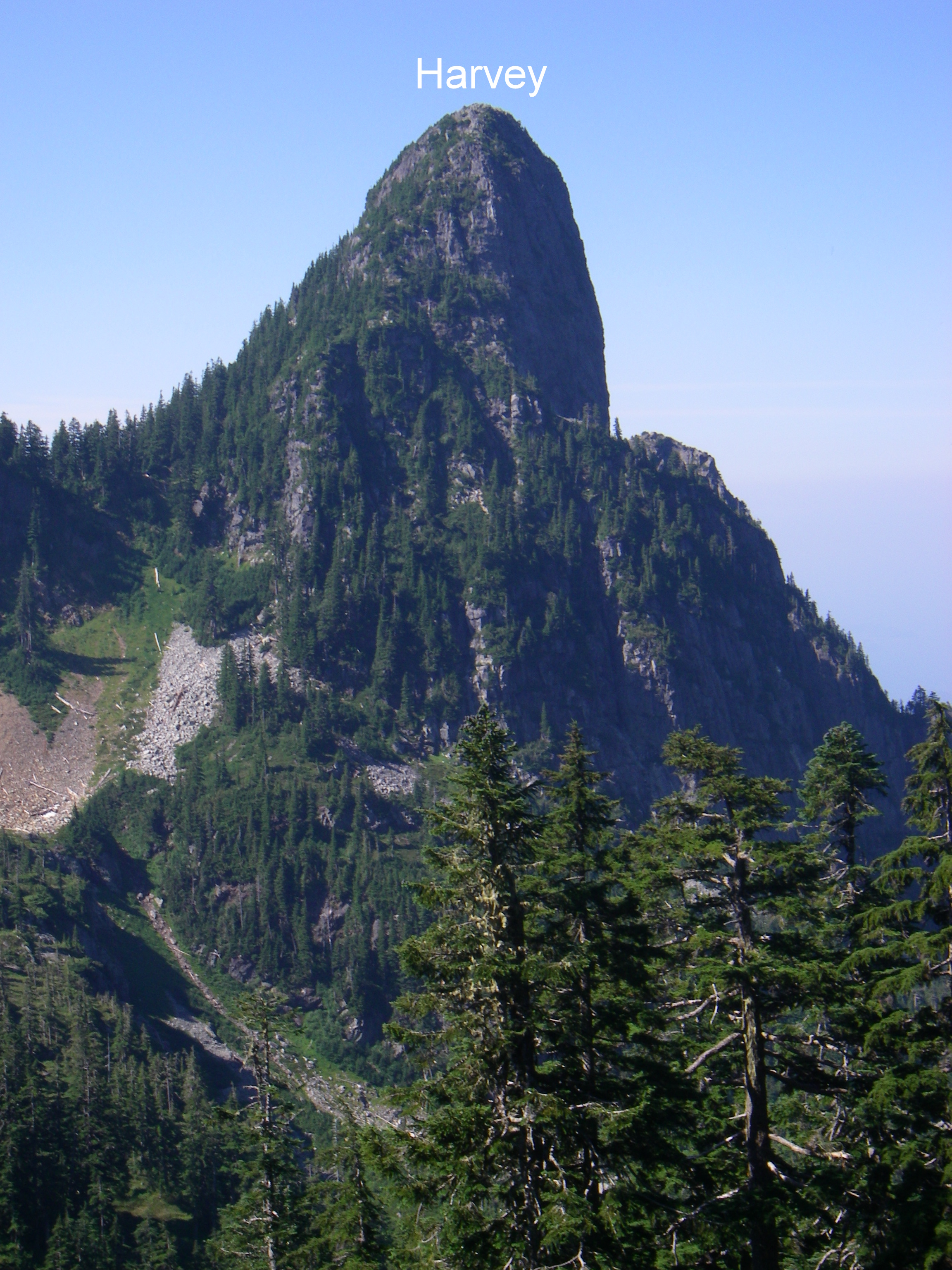
Of particular worthy note, the blueberries on Harvey Pass: the range of acidity, sweetness, aromas, and flavors is incredible.
Enchantment and Gambier?
Word has it the route is somewhat mysterious, definitely enchanting. I'd love to find out. Anyone interested in joining me one fine, sunny day?
I also have some unfinished business to take care of on Gambier Island. 'Was thinking of paying respects to Liddell and maybe Burt's with some flagging tape and pruning shears.
Enchantment route
this is what is mysterious and enchanting... how to get there and what to expect!
Which way do you want to go
Which way do you want to go to ENC? Up from Lions Bay?
Let me know when you want to go, and I'll be happy to join you if possible. (I'm likely out of town this weekend though.)
If our availabilities line up
If our availabilities line up I'd be down for some Enchanting. I just had my first taste of the northern parts of the HSCT and I'm itching to get back. Keep me posted, Thursdays, Fridays and Sundays work best for me.
hollyburn
I bruised my heel playing ultimate a couple of weeks ago, and I hadn't been on the trails since. It's still not completely healed, but I couldn't sit around any longer. I didn't want to put too much stress on my heel, so I biked from Kits up to the Cypress parking lot, and then carefully ran up Hollyburn. Got a nice view of the sunset during the ride back down. Put me down for HOL, a waterbag if using a bicycle is allowed.
Bagging Companion(s) needed for Sunday
Anyone interested in joining me for some bagging this Sunday?
I'm thinking of 2 options:
1) A partial loop on Seymour via the Elsay Lake trail up to 3 peaks: Elsay; Runner; Seymour (~ 20 km)
2) A long out and back (30 - 35 km) to Coliseum and Burwell.
The first option is somewhat shorter and will have a mix of running and scrambling. The second option will be mostly running but is a lot longer distance and somewhat longer time.
You can email me directly at bill.dagg@shaw.ca or give me a call at 778.835.6848.
Cheers
Bill
Suicide is Painless
... and, with Dog Mountain, is a blueberry feast! Jess and I took advantage of Jess's last flex day and headed up to Suicide Bluffs by way of Dog Mountain. The weather wasn't perfect (it got a little misty by the time we got to Suicide) but held off for the most part and offered some views on a somewhat chilly day for mid-August. Nevertheless it was an enjoyable little adventure just over 1:45 including stops for photos and a fair amount of time feasting on the now ripe and abundant blueberries (particularly on the western slope of the Dog Mountain bluff).
Please mark both Jess and I down for SUI.
It was a great year for
It was a great year for Salmon berries and now the blue berries are looking great too, watch out for furry fruit pickers kids!
Misadvetures of the time pressured dog owner
So anyway this years bagging season has been quite succesful by my own low standards and I was looking forward on make an attempt on Dam and Little Goat by way of Dreamweaver and the Eric the Red trail, thereby sneaking Stetson in round the back of Grouse Mountain.
As we ran up Dreamweaver the urge to explore got the better of me we headed across Mosquito Creek and up to the Lower Grouse Mountain Highway to the little connector trail between the two grouse roads. This was a little more challanging than expected (you know you are having a good time when you see North Shore Rescue flagging tape) but thats a story for another day. Once at the col between Grouse and Fromme we headed off along Pipeline / Erik The Red which was great but very steep once across the small rockfield. Around this time the pissing rain began and Pertex jacket failed within seconds but that was not a surprise and we pressed on to the small open area where the trail splits in my wisdom / cold / summit fever I elected to go right which was very nice but clearly not a peak, a quick check on the map and it was confirm to be Thunderbird Ridge.
Looking at my watch and weather we decided to head for home rather than any kind of qualifying peak and there the fun began, fell three times on the descent and did an impressive job on my ankle (medicinal beer has been applied and it is much better) and lost my watch before making at back to the safety of the mountain highway and the Fromme mountain bike trails.
So please Chief Bagger put Stetson and James down for nothing. We shall be back with more focus, better weather and about 1 hours more time soon....
LOVE IT!
sometimes the colossal disaster hikes are the most memorable ones.
Dog Friendly Dam From Dempsey
So anyway three weeks after disappointment, displaced watches and nearly dislocated ankles we returned....
Stetson and I set of from the Dempsey Bramear trail head and head up St Mary's, Dream Weaver, Per Gynt, Mountain Highway, Pipeline Pass, Erik the Red, Thunderbird Ridge and Alpine Trail to Dam Mountain. We arrived there in a little under two hours (much to the surprise of the picnicing hikers) at a Clif bar turned around and was back at the car 90 minutes later. Nothing lost nothing gained except a small handful of blue berriers.
Please can you put Stetson and I down for DAM. Cheers
SNE LYN and SLY
I ventured up Hydraulic Creek trail after work today to bag South Needle, Lynn and South Lynn.
Here is the breakdown of how long that took me at a steady clip.
Gazebo to ...
... Hydraulic creek (on the asphalt / use Fisherman's trail for more a more scenic route) 32 min
... South Needle 1hr 45min
... Lynn Peak 2hrs 25min
... South Lynn 2hrs 50min
... Lynn Lookout 3hrs
... Gazebo 3hrs 47min
Me and my chocolate chip cookie on Lynn peak
Baggermeister put me down for SLY LYN and SNE please
delete
delete
Runner and Elsay Peaks
I had booked the guided bag with James and Stetson the Mountain Hound today. Runner (who came up with that name ... Scrambler would be more appropriate) and Elsay were our objective. James had been up this route before and was therefore the designated tour guide.
There were high clouds and it was spitting rain a couple of times, but overall we had great conditions for the mission. Well ok, there was some thunder rumbling in the distance at one point, which had us survey the sky and wonder if we should leave the bagging of Elsay for another day. We didn't and everything worked out great. The very top section to Runner peak is quite the scramble, but beside that it's all good old North Shore hiking punctuated by some running where possible. The trip took about 5 1/2 hours with just a couple of short snack breaks.
Just below Runner's Peak. James and Stetson looking pretty relaxed.
Peak of Mt Elsay.
Even I was able to spot this Geocache in the cairn on Mt Elsay.
Please put James and Marc down for RUN and ELS and Stetson the Mountain Hound for ELS
One more thing Marc, what was
One more thing Marc, what was our average speed? The descent must have got us up to 3km/h!
I am afraid it didn't
Bagging is just quite a bit slower than running. I havn't looked it up, but I am afraid we are still in the 2point something range.
Join me for SLY LYN SNE Monday afternoon
Brunswick Sweep this Saturday August 10th
Bishop
Bagged Bishop (BIS) on Monday. Biked up the LSCR road to the trail leading up to Vicar Lake and Mt Bishop. Stashed the bikes at the trailhead. The trail from the valley to Vicar Lakes is steep with many ropes to help along the way. Lots of bugs around the lake, so we didn't linger.
The trail is less steep from Vicar Lake to the summit. There are some patches of snow and streams of meltwater just below the summit.
View from the summit facing East.
The whole trip took 5.5 hours with about 1 hour of biking. We ran a little during the descent.
Bluffs taper bag
What's a tapering bagger to do on a sunny Sunday?
An aesthetic west to east loop of the 2 Seymour bluffs, with only a couple of road crossings.
Park & start at the "Vancouver Picnic Area", about half way up the Seymour access road at elevation 560m.
Head N on Enquist trail, then W and down Run Lola Run for a bit, turn NE again on a loamy Magic Kingdom, crossing Enquist, and continuing up Magic Kingdom which now turns into blow-down galore, steeply carving its way up the mountain until it spits you out near the Seymour ski area, at the works-yard.
Cross the road, head north on the trail behind the various Seymour huts, and get to the Dog Mt trailhead.
Visit the Dog Mt bluffs, and continue NE on Suicide bluffs trail to the bluffs viewpoint, then bag the bluffs themselves.
Unfortunately, the whole area was under cloud cover, affording zero views.
The Suicide bluffs trail ends at the Mt. Seymour main trail - Loop N of Mystery Peak, then take the trail heading NE under the base of the Brockton chair, and head up to bag DePencier bluffs, again under complete cloud cover.
Time to go downhill, but the hard way! The Perimeter trail heads S and down, but it's slow going - Overgrown with Salal, underbrush, and wet & slippery rocks/roots from yesterday's rain, one has to take it slowly down the mountain, staying in focus not to miss a couple of sneaky left turns.
At the Goldie Lake turn-off the going gets easier, as I soon join Old Buck and sprint down it to head back via a connector trail to the picnic site where I started.
I wouldn't recommend using upper Magic Kingdom (blow downs, route finding) or Upper Perimeter (overgrown, tricky junctions) at this time, unless you know what you're doing. For experienced baggers, tapering or not, this is a beatiful loop.
Baggermeister: SUI and DEP please.
Paton Coliseum Burwell
Paul, Spencer and I set out to Conquer Paton, Coliseum and Burwell today. We decided to bike the 9.5 km on the LSCR road to the trailhead, which was still nice and quiet in the morning. After stashing the bikes we started ascending the steep, but exceptionally well marked trail up to Paton. We were able to get some nice partial views on the way up, however we were in the clouds on the actual peak. On to Coliseum then. The Route was still well flagged all the way up to the summit. On the way there we got all excited when the Haze burned off and we were rewarded with stunning views all around. Just enough clouds lingered to provide some nice accents among the surrounding peaks. On to Burwell. The flagging became less, but between some common sense, some cairns and some tape the journey to the peak was easy enough.
Then we had an idea which would in the end turn a 12k trip into 32k (excluding the biking).
A member of our group (who chooses to remain annonymous) thought "Wouldn't it be nice to get some running in after all this scrambling and hiking?!" So we decided to descend down towards Norvan Falls. Run the Headwaters Trail and then the LSCR road to retrieve the bikes (Which we wouldn't have needed if we knew we'd do the entire loop).
We even did an extra loop around Rice Lake for reasons none of us fully comprehends.
We clocked in at 7h 30min on our feet in the end which worked out to about 8h 45min including the bike ride and the transitioning between disciplines.
I can't speak for the other two guys, but I'm pretty fried tonight.
Please put Paul, Spencer and Marc down for PAT COL BUR
Bill's Great Peak Ascent
Full report here. Please mark me down for Goat (GOA).
Thank-you kind sir!
Please post your photos!
PHOTOS: Please post your photos, too. Add to the CFA Flickr Pool (instructions here. It's easy!), tag your photos: ClubFatAss ClubFatAssEvents ClubFatAssEvents2013 BaggerChallenge2013 BaggerChallenge (with a space separating each tag on the flickr template)
SLY vs. LYN
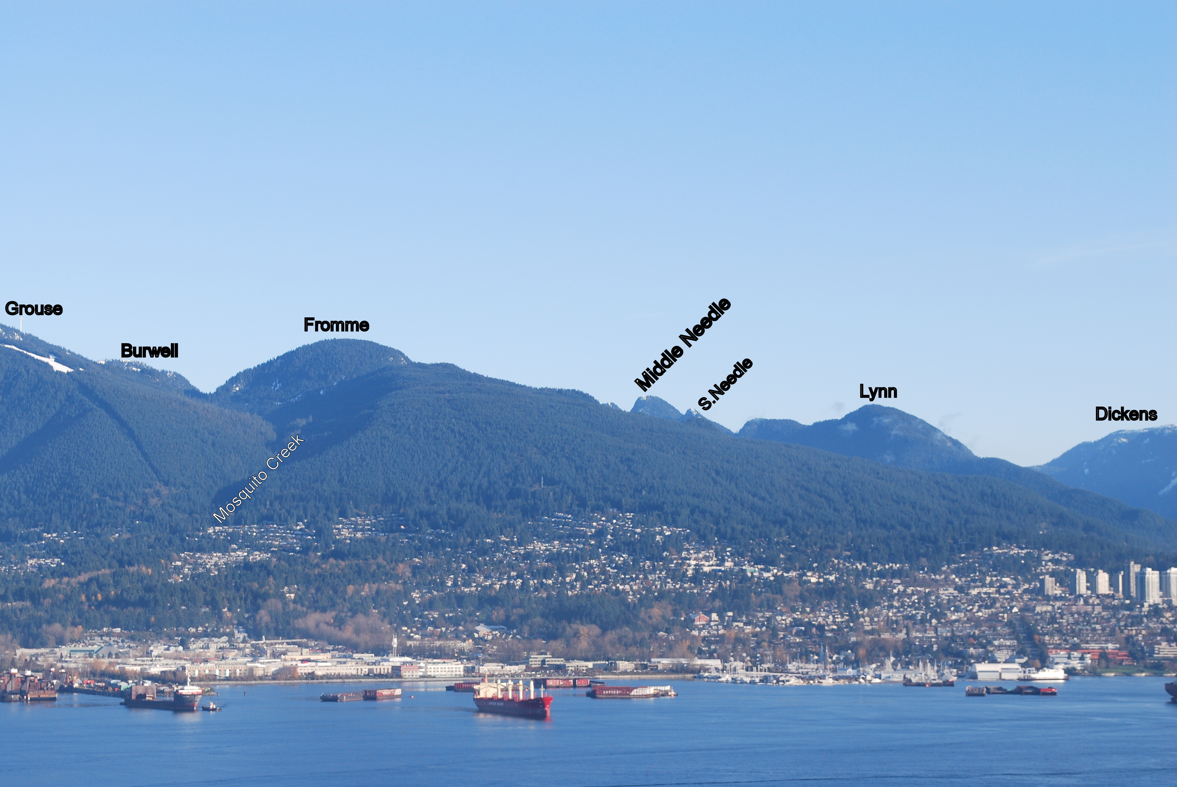
The Lynn Ridge is confusing.
First, find Hydraulic Creek on the LSCR map.
North of Hydraulic Creek are the Needles.
South of Hydraulic Creek are the "Lynn Peaks" (of which there are 5 wooded bumps on the ridge).
The bump just south of Hydraulic Creek on the ridge is true Lynn Peak (LYN), at 1015 metres: the highest point.
SLY (at 999m) is about 1K north of the balloon viewpoint on the well-trod Lynn Trail.
Its lofty summit is marked by a tree around which is wrapped flagging tape marked, confusingly, "Lynn Peak".
The balloon viewpoint means nothing to the true bagger, or to any person of taste and character.
Monday Night Bags
So anyway needing a change of scene and focus I arrived at the Cypress Parking Lot at 7.10, unleashed the mountain hound who promptly ran off in the wrong direction (twice). Once he was retrieved and refocused we hit the BP to the Old Stachan Trail then branched off to Hollyburn where the mountain hound got himself cliffed out. Once that was resolved we pushed up to the deserted Hollyburn Peak before dropping back to climb Strachan. Fantasic run across the south summit in golden sunlight before a quick down up to gain the north summit, admired the view in light breeze (no bugs) and watch the sun dip close to the Sunshine coast before heading down Chrstmas gully, trail was soon lost and a more radical descent route was taken, no further cowardice was shown from the mountain hound and we arrived at the junction with the HSCT at 9.10, a quick burn along the HSCT and down a ski run and we were back at the car at 9.30.
Please put James and Stetson down for HOL and STR (at the fourth attempt)
Looking for Bagging Buddies for Sun Aug 4 and Sun 11
I was thinking about South Lynn, Lynn and South Needle or maybe Paton, Coliseum and Burwell (which would involve some biking), but I am flexible if you want to suggest another mission.
I am happy to start early.
Let me know if you are interested.
I'd be up for the 4th.
Hey Marc,
I'd be up for the Coliseum loop on the 4th if you're keen? I fly in Saturday night, so a reasonably early (not crazy early) would be good. Say 8am?
Spencer
Paton and Coliseum on the 4th
Hey Spencer and Paul,
Let's meet at the Gazebo at 8am on Sun the 4th then. Hope that works and if people want to joins us they'd be welcome. I am not sure if we'll manage Burwell too. I havn't been out that way before.
Just to make sure everybody is on the same page. We'll be going out on the bikes before climbing up Paton.
I'll prepare for a five hour kinda outing I guess?
Marc
Hi Marc, I bagged Lynn and
Hi Marc,
I bagged Lynn and the Needles last Saturday, but I'd be interested in Paton, Coliseum, and Burwell. Either the 4th or 11th would work for me.
Cheers,
Paul