This is an extreme run. You may want to attempt it only if you have done most of the Baden Powell Trail in the past. We expect to have all weather conditions on run day including snow on the ground at higher elevations in the Hollyburn and Cypress Mountain areas.
We really don't want you to get lost. For the Baden Powell Trail, you must know your way in advance if you're going to run anything of significant distance. Maps and GPS's and the like will only take you so far. If you really want to do this event, go and learn the route in advance. Your only other choice is to promise to stay with someone that knows their way.
For a printer friendly version please scroll to the bottom of this page and follow the link.
|
Time
|
Vancouver 100 - Agenda and Course Description
|
|
|
0457
|
Meet at Panorama Park in Deep Cove
|
|
|
0458
|
Sign-in
|
|
|
0459
|
Welcome, final briefing, group photo
|
|
|
0500
|
We start with 1.5 kms at the beginning for a nice warm up run in the Cove.
Then, the climb out of Deep Cove begins at the Baden Powell sign at the North end of the Panorama Park parking lot. Watch for the orange BP Triangles nailed to the trees regularly along the way. Follow the Baden Powell Trail the entire way. Distance is 62.5 miles (100Km) for the round trip. There are no usefull maps of the BP Trail yet. You either know the way yourself or you will stick with someone that does know the route.
|
|
|
|
Feel free to turn around at any point to make the run as short as you want. Also feel free to pick up with us at any point along the way. Bring extra supplies for everyone!
|
|
|
|
1.0 miles (1.6Km) In Deep Cove before getting on the trail. |
|
|
|
10 miles (16 Km) Lower Seymour Conservation Reserve
|
|
|
17.5 miles (28 Km) Cleveland Dam
|
|
|
25 miles (40 Km) Cypress Bowl
On your way up Hollyburn after emerging from the Chute you may need these directions:
-
You will naturally be on West Lake Loop.
-
Take Grand National to the left.
-
Go past Jack Spratt.
-
Left on Sitzmark.
-
Pick up water from the tap at the Hollyburn Ranger Station where the lodge is. The water is not treated but it seems to be safe. It is only available after most of the snow has melted.
-
Right on Zig Zag. If you end up on Roller Coaster that is okay.
-
Left on Lower Wells Gray.
-
Go past Sitzmark onto Upper Wells Gray.
-
Cross the power line and at the Upper Warming Hut go straight up Pacific on the right hand side of the hut.
-
You are now on Pacific.
-
Stay on Pacific. Go past Unkown Lake on your right and go past two Triangle Lake trails on your left.
-
When you see a sign for Romstand trail stay on the main run going straight and up.
-
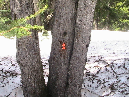
Look for the double BP triangles (see picture below) generally straight ahead but to the left a bit.
-
From there you take a 45 degree b-line to the bridge and then off into the trees but try and follow the BP Trail markers whenever possible. You may need to go into the gulley above the bridge as it is not passable in some years before all the snow melts.
-
Cross into the forest and good luck from there. Follow the markers.
|
|
|
32.5 miles (52 Km) Nelson Canyon Park, West Vancouver
|
|
|
40 miles (64 Km) Cypress Bowl
|
|
|
47.5 miles (76 Km) Cleveland Dam
|
|
|
55 miles (88 Km) Lower Seymour Conservation Reserve
|
|
|
62.5 miles (100 Km) Panorama Park, Deep Cove
|
|
|
0500
|
Finish! BP Sign: You made it! Arrive back at the parking lot.
|
|
|
|
Congratulate yourself ! Now go home and rest a while.
|
|
|
4:30 pm Sunday June 2, 2013
|
Two Lions Public House (formerly Mosquito Creek Bar & Grill), 2601 Westview Drive, North Vancouver 604-983-3083
|
|
|
|
This is a picture of new BP markers posted in May 2008. (In 2009 they had turned a bit yellow.) They are at the Hollyburn Mountain Cross-Country Ski run heading toward the Cypress Bowl parking lot from the ski run into the trees. You can see these markers from the ski run. From this point head toward the gully on a 45 degree downward angle. You will see other BP markers and eventually come to the crossing of the small creek. In very heavy snow years you will not be able to see the wooden bridge that crosses the creek. In light snow years you will hear the creek easily and see the bridge. 2008 was a very heavy snow year.
|
|


