name: Fromme – the dumb way
start: Grouse parking lot
peaks: Mt Fromme
finish: Grouse parking lot
estimated time: a sad 5 hours for this insane route of only 11.2 miles and 4715 ft of climbing
access to water: Mosquito Creek at the bridge, smaller creeks enroute – I carried 2 liters and had almost a liter to spare – it was not hot and sunny
bailout points: You mean besides taking a better route up in the first place? You could bail when you cross Mountain Highway, leave the single track and run the road back down. On the return, you could take Skyline, as I did, rather than returning on the Baden-Powell.
mobile coverage: I only checked once on the descent just a few minutes down from the south summit – had full bars showing.
proposed by: no plan other than to spend a good portion of the day on the trails and bag Fromme – successful on both counts.
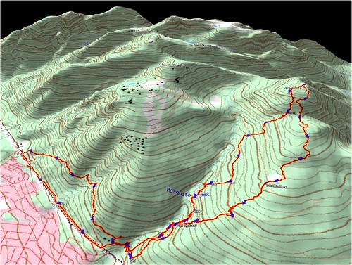
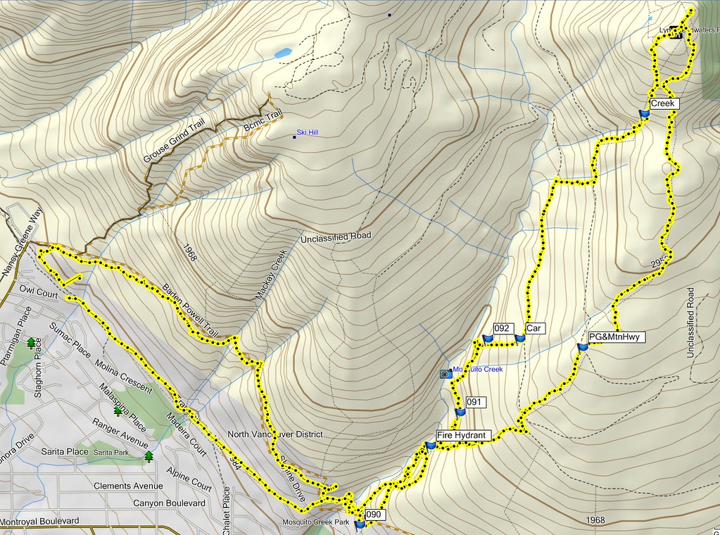
details: Considering this bag is pretty low on the difficulty scale with only a few from the list easier to find and get to, it certainly ended up being a long run. Bad omen at the start, parking at Grouse on the day of the Seek the Peak Relay. Had to park at the far east end of the gravel lot. Rather than fighting for trail space with the racers, I took the “winter” trail access to the BP from the parking lot a little east of the gate. Cheered on a few guys near the front of the pack then continued east on the BP trail to the Mosquito Creek bridge.
Here’s where things went haywire. I distinctly remember someone telling me (Action Jackson maybe, always a dependable source of route info) that they took the 2nd (or was it 3rd) trail after the bridge that heads north off the BP. They said the side trail closest to the east side of the bridge doesn’t go far. From here it should have been pretty easy, a second chance to see this section on my return showed me just how easy it should have been. There are markers, a short distance up the north-bound trail there is even a sign that says Mtn Fromme. That sign just happens to be at an intersection where the trail straight ahead looks nice and wide, the ACTUAL trail is narrow and turns east. I continued on merrily on this wide trail parallel to the creek, marked only with intermittent exposure of an old cast iron water line.
The trail dwindles and is blocked by deadfall. My GPS tells me that the trail I want is running parallel some 500 to 800 feet to the east. Stubbornness prevails, the pace slows and I am bushwhacking between short sections of what is probably ancient logging skidline.
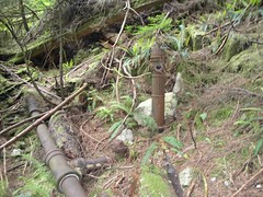
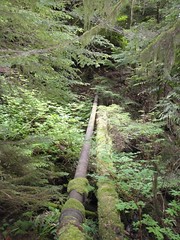
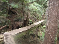
Smack in the middle of nowhere, without a dog or curb in sight, there is a hydrant. A little further on, a sketchy pipe bridge, then a new looking wooden foot bridge.
I finally give in to the GPS as the trail it shows has now taken a hard turn to the east away from the creek. The route forward has disappeared at the edge of a rockslide. Choices now are back toward the BP (smarter) or up the rockslide because my GPS tells me the “trail” should be very close to the top. Why in the world I would take faith in the GPS now, when I ignored it completely when it would have been so easy to verify the existence of another trail is something only a dumbass bushwhacker would know.
At coords N49.36593 W123.06997 (you can cut and paste that into Google Earth) I turned up the rockslide. Partway up I thought I found the trail again when the cast iron pipe came into view. It turned out to be a dead end at another hydrant at N49.36603 W123.06931. It was a bit of a scramble to get over the edge of the slide into the nice sharp thorns of berry bushes and bramble. Determined to prove the GPS right or wrong, I bushwhacked on uphill only to find this at N49.36605 W123.06725
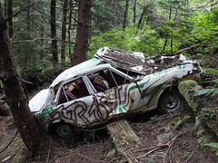
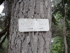
I was surprised to see it was tagged as a gift to nature from the local 2003 Grads. I thought the current grads cared about the environment more than us grads of the early 70’s. Inspired by the hope that the car couldn’t have made it that far off the road and the telltale bright green of thick underbrush found alongside roads and trails, I continued up to find the trail the runs parallel to Mountain Highway from the 6th switchback up to the point where Mountain Highway shifts from Mt Fromme to Grouse Mtn. I came out onto this trail about halfway along, and traveled about .6 miles further north on it. At that point I could see by the trusty GPS that the intersection of Mtn Highway and the north access trail to Mt Fromme were east and above me. Of course, it turned out there was another rockslide/creek bed here so I opted for the climb again. N49.37449 W123.06493 I see now from Google Earth that there was one more creek bed to the north connecting the trail and road, but the one I chose to climb wasn’t so bad. I made it up to Mountain Highway with only a few more thorn scratches, traveled north on the road about a quarter of a mile and found the well marked north trail head to Fromme.
From this point, it was a simple well marked climb to the north summit. Too clouded in for any views.
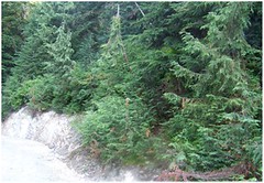
There was a bit of snow on the ground to the north summit, more between the north and south summits.
A quick hammer down the south access, Per Gynt, Bill’s Trail and Executioner brought me back to the east side of the BP Trail bridge over Mosquito Creek. I took the easy route back to the car along Skyline, glad now that it was in the close-to-me east end of the parking lot.
alternatives: This would have been much simpler running up Mountain Highway to the north access trailhead at N49.37653 W123.06200.
I would recommend doing the summits north to south as the basically unbroken run of trail down from the south summit is a hoot. On the descent, watch where you first come back onto Mountain Highway at the bottom of Per Gynt , it can be a little tricky finding the continuation of the trail down. I headed east to the trail head marked by a wooden post (no sign yet), I believe to be Executioner.


Comments
good one Rick
It just goes to show you can make a day of it on any of the local mountains. I like to go up Fromme by way of the various trails coming out of Lynn Valley and I am never quite sure where I'm going to end up. But I do know that up is still up and coming off Fromme is a hoot just like you said.
Nice write-up and route.
Nice write-up and route. Very similar to what we did last weekend - without the getting of route and without GPS ;-) We took the decommissioned trail (Old Grouse Mountain Highway, admired the fire hydrant and pipe in the middle of nowhere, took a detour across the Kwai Bridge and to the rockslide, then up Per Gynt and Bill's Trail (where you hammered down). We climbed down the Pipe Pass Trail, Mountain Highway and then back on an unnamed trail west of Executioner back to Old Mountain Highway. Took us 5h as well (without the BP and Powerline) stretch.