 Mount Apodaca. A-po-da-ca. Sounds like some exotic peak in the Pyrenees or maybe the South American Andes, doesn't it?
In fact, Apodaca is a pimple on the face of Bowen Island. OK, that's a bit of an exaggeration... it's a festering boil on Bowen's butt end.
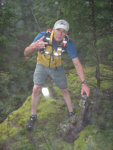
I am, by nature, a "glass is half-full" kinda guy. True, I tend to favor sunshine and singing birdies when I embark on a peak bagging expedition, so feel free to take my comments with a grain of salt, because the weather was less than ideal this day and the state of the weather tends to taint my perspective. The opportunity to run with good friends trumps all, however, so when Crerar and Conroy said, "Sunday is the day", I postponed plans to bag this bad boy on a gloriously sunny Saturday.
First, some background. Bowen Island, a short ferry ride from the Vancouver suburb of Horseshoe Bay, is home to 3 distinctive mountains. Two of the peaks, Mount Gardner and Mount Collins, are in the Bagger Challenge. The third, which happens to be the second-highest of the 3 mountains, is not in the competition at the time of this writing. It's also not very well known. To that end, getting to the top represented an interesting challenge and also an opportunity to identify another potential peak for the Bagger Challenge.
From the topographic maps that, of course, Conroy, Crerar and I studied meticulously beforehand, we noted that Apodaca did not offer a peak, per se. The top of the mountain was characterized by wide topo lines and what looked to be several knolls. The high point of land is located in the Bowen Island Ecological Reserve. Technically speaking, one should get a permit before entering this area. Given the last-minute nature of our plans, we did not do this.
A pal of mine lives in the Valhalla Estates area of Bowen Island. He shared with me that by driving to his place, one could save a bunch of time. So we did. It was spitting rain and so foggy we could barely see the road in front of us as we drove uphill from the Bowen ferry terminal. Valhalla is a private enclave, but we drove in anyway. We also parked the car where we probably shouldn't have.
Excited as school kids at the prospect of being first baggers (at least in our little circle of friends), we packed our hydration packs for adventure. The three of us had plenty of food and water. We were dressed for success. Given that I took my wife's pack, the emergency space blanket and tampons were still in a side pocket. Crerar had a topo map. Conroy had one in his head, complete with cabins and water towers. Between the 3 of us, we had 2 Garmin GPS units and four (4) AA batteries.
Given that my Bowen pal had never explored his own back yard, we 3 trailfinders were on our own for directions. We set off by climbing up an overgrown dirt road which led to a big green water tower. As if by miracle, we stumbled upon a totally-decent marked trail. "Piece of cake", we thought.
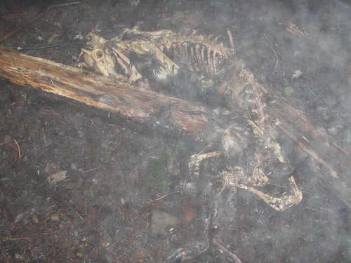
This trail went upwards for about a kilometer, then headed steeply downhill. Bad sign if one is looking for a peak. We opted to head into the bush at this point. The fact that I immediately stumbled across a skeleton should have served as an omen.
Crerar and I checked the GPS to see if we had arrived at the peak. One bar. Two bars. One bar. Repeat. To summarize, we couldn't get a signal. When we compared devices, it soon became apparent that my Craigslist special did not have topo maps installed. My bad for not confirming this before we set out. Compass? Conroy, did you bring an old school compass? Of course not!
We soldiered on into the fog, stumbling over rotten blowdown toward what appeared to be a higher point of land. This continued for about 3 hours. At times, the GPS did work briefly, but our destination was always just "over there". Crerar's souped-up GPS ran out of batteries first.
The topology of Apodaca is simple: blowdown, rotten wood, moss and swamp. This appears to go on forever, especially when viewed in the fog. Our expedition was plagued by frequent downpours.
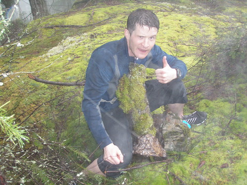
Finally, we arrived at a rocky outcrop characterized by the root-ball of a big, blown-down tree. We transferred batteries from my GPS to Crerar's. As best we could tell, this ugly bit of scrub in the middle of endless blowdown was our destination. Hurrah... we could claim to have bagged Mount Apodaca!
Conroy celebrated by finding the most phallic piece of rock he could find and set about to build a lingam. Crerar and I added to it, as no peak should be without a cairn. We took a few photos, as true baggers do, then set off to find our way to the nearest warm, dry pub.
I've never come across a skeleton during a run before, but I stumbled across 2 more as we took the scenic route to the nearest road. It was not long after stepping on skelleton #3 that we came across the locals. (To protect the identity of our new-found friends, let's call the alpha local Joe Bob, or JB for short.) One might think that baggers hang tight together while bushwhacking in unknown woods, but this is not always the case. In particular, our case, as Conroy, Crerar and I each figured our way was the right way. So as to not lose each other completely, and to confirm that the snapping wood was not the snapping of a tibia, we'd let out the occasional hoot in the fog. The hill people had apparently heard our hooting and figured we were out to take something that belonged to Joe Bob (his still, perhaps?), so JB and 2 of his large bodyguards set out to fix what they perceived to be a problem.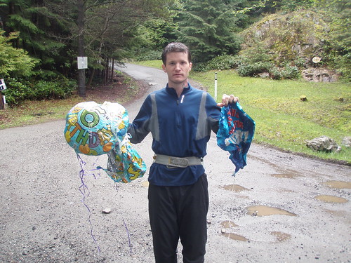
Crerar was first to make contact. You'll have to hear the story from him, as I was still stumbling over rotten blowdown part-way up the hill, but suffice to say, he must have done an admirable job of diplomacy because when I arrived at the party, everyone appeared to be as happy as clams. I have to say I was a bit taken aback by the appearance of JB, however. Dude in his late 40's, black leather pants, snakeskin cowboy boots with silver tips, a big bowie knife on his belt, shirt opened to his belly-button, lots of chains, puffy blond shoulder-length hair with pink and purple streaks. 'Looked a bit out of place, I thought. But hey, who am I to judge? Picture 3 city fellers in spandex, covered in mud, legs leaking blood, one carrying a couple of birthday baloons poking around in your back yard and you get the picture of our initial awkward moment.
So JB and his 2 big pals led us down to the dirt access road. But by now, we were like old buddies, so JB and the lads insisted on taking us on a cool trail not far from JB's property. This is where we learned of JB's recently deceased Rottweiler, Death, as well as some colorful incidents in his life that included a police incident at a Canadian Tire store in Surrey. Anyway, we soon learned that, as nice as this particular trail was, it was taking us farther away from the pub, so JB and company led us back to his place and insisted on showing us his Harleys before sending us on our way. One of the chopped hogs had a sticker, "Gas, grass or ass... nobody rides for free" on it. I suspect JB meant it! I asked if JB would mind if I took a little video, but he politely, but firmly declined.
Back on the road, the pace picked up substantially. That is, until Crerar almost jumped out of his skin right in front of me. "It's only a llama, bro." And so it was.
With the pub almost in sight, I think it was me who suggested we take a short cut and pick up the car first. Clearly, the trail Crerar had sketched on his map would pick up at the end of the side road we were on and take us directly to the car. While this idea met with universal approval, it turned out to be a case of poor judgment, as we ended up climbing back up to the top of the mountain and spending the better part of an hour and a half in blowdown Hell, only to find ourselves back were we started. By this time, my skeleton count had risen to 4 and our stomachs were growling in unison.
 The actual cross-mountain route ended up being at a lower altitude to where we suspected. Once found, it proved to be a delightful trail that indeed led directly to the car.
Our next adventure was to find a pub. Soaked to the skin, covered in mud, blood and pine needles after 6.5 hours of bushwhacking, we were a scary sight.
There are several decent pubs on Bowen Island, but on a Sunday afternoon of the Stanley Cup playoffs with the Canucks in play, most were closed for private functions. The bistro we finally located in the hidden Artisan Square mall was a gift from heaven. Crerar's first comment was, "Hey, they have Macallans on tap!" as Conroy perused the wine list and I eyed the Leffe beer from Belgium. The mouth-watering menu offered freshly baked country bread, imported cheeses, home-made soups my favorite food: pulled pork sandwiches. As the rain thundered down just outside the window, we inhaled our meals and celebrated our victory.
There are already efforts underfoot to find a better way to the peak of Apodaca. If you have any thoughts, please share them here for the benefit of those who follow!


Comments
I hear banjo music
Does a brass pig alone in the woods make squealling sounds?
I see, with the snow still lingering on the peaks, you look for hills to bag and hope to have them added to the bagging list. Still, wish you had called. I always (almost) have fresh batteries in the GPS. Looks like it might have been easier to start at Harding Road north of the "peak".
The Winning Route
has yet to be confirmed, however, I don't think it was the one we took!
I'm good to go back and try from Harding or from JB's road, though on second thought... The nice trail at Valhalla we ended up *not* following might lead to that valley with the creek in it... or beyond. Either way, bring your bike and we can do Collins, as well. Tell me when you're good to go...