 Over the last year and a half the Powell River Parks and Wilderness Society (PR PAWS) has built four large shelters and a hut in strategic locations along the Sunshine Coast Trail (SCT). Our plans call for two more shelters and another hut to be built this year and next. Together with some B&Bs they will provide shelter/accommodation every 10 to 20 km so hikers don't have to carry a tent.
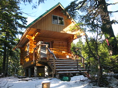
Because the SCT has a couple of dozen access points, the new shelters have become popular day-hike destinations. The structures share the same basic design of food preparation counters and a picnic table on the main floor, and a sleeping loft upstairs that can accommodate up to a dozen people. Of course, each one also has a pit toilet nearby. You can see many pictures by going to the SCT website www.sunshinecoast-trail.com and clicking on the New Shelters link, or clicking here: http://newshelters.blogspot.com/.
The 18th Annual Marathon Shuffle on Sunday, April 17 will take you right past the Rieveley Pond Shelter, as well as the picnic shelter at Little Sliammon Lake. We hope you'll get a chance to come out and enjoy this annual rite of spring. More info about the Marathon Shuffle here.


Comments
Sunshine Coast Trail south from Shinglemill
Hey Eagle:
I am in Powell River and trying to figure out the Sunshine Coast Trail east of the Shinglemill.
There are lots of roads and I can't figure out where it goes. I made it as far as Mowatt Bay and then I gave up and ran on some other trails. There was a trail heading up across some bluffs but it got pretty narrow and slippery. I didn't see any markers for a while so I gave up. On the good news front I did check out a lot of other trails and logging roads but they are a real maze close to town at least. Blue Lake Trail was particularly nice to let it rip along. Any tips around there?
thanks,
Ryan
Mowat Bay reroute
Hi Ryan,
You have to run up Mowat Avenue, turn left onto Cranberry Street, run about 800 east above Cranberry Lake, until you come to the first street after the gravel pit up the hill to the left on Tatlow Street, take the next left on Warner Street, and then the next right up Grenville Avenue. From there head straight uphill 400 m following a rugged extension of Grenville which then bends left above the gravel pit. Carry on as this Telus road levels out and swings around to the right and begins climbing again with the cutblock on your right and views of Powell Lake and Mowat Bay from which you have come down to your left. Once you pass an open area used as parking area from time to time, there are again trees that grow on the left. About 50 m farther uphill there is a car pull out on the right hand side in the cutblock. The Sunshine Coast Trail resumes opposite, on your left as you are facing uphill. Look hard because vandals keep obscuring the entrance to the trail. A little careful investigation of black paint on on tree trunks will indicate to you the handiwork of the vandals who have covered over our signage, again and again. They also keep destroying the wooden signs which we have nailed up high numerous times. You will note the big nailheads still sticking out. Once you are on the trail it's not long before the obfuscation comes to an end and you can hike without worrying about whether you are on the right trail.
Trail Guide
Hey Ryan,
Secret training, eh? I found that having a copy of this little gem in my hydration pack saved me a lot of grief. It might help you, too!
I should get that but...
In this case the trail was closed due to private land ownership issues. I did see the larger trail go off into an area that was clearly fenced off and marked private property. I was climbing across the cliffs below the bluffs below the trail as the old trail went up above on the private land. I did eventually find it another day, but would never have without Eagle's description. You have to go on some obscure roads that would not be in the book near Cranberry Lake. What I should have done is kept climbing across the cliffs, it is not far around past the property from where I had already made it, I just wasn't sure the trail would be there if I did because it was obvious Eagle wasn't going to be sending backpackers across there as it had gone from hiking to scrambling to border line climbing.
A Thing of Beauty
Congrats to you and your team, Eagle. What a beautiful oasis in the woods!
If my memory serves me, this section of the trail with views out over the ocean from the top of Troubridge Mountain was stunningly beautiful.
I poked around in the photos and video you shared regarding the construction and saw many familiar faces. It shows that building the shelters is a true labor of love. It's amazing to me how much progress you have made over the past couple of years toward achieving your vision of making the Sunshine Coast Trail a worldwide destination for hikers... and even trail runners.
How far would you guestimate the distance to be from the Saltery Bay ferry terminal to the new cabin? How many vertical meters? Seems to me that would make for a decent out-and-back run.
When you mentioned that folks were making the trek to the new cabin on snowshoes in 5 hours, was that from the road at the top or from the bottom? Is the trail open and completely covered in snow or in the trees and partially covered? Has anyone ever run to the cabin and back on snowshoes? Always curious about first bagger opportunities!
Troubridge Challenge
Hi Ean, it's about 18 km up Mount Troubridge with a 1300 m climb - probably the equivalent of two Grouse Grinds - and then you turn around and head downhill.
Yeah, the 5-hour snowshoe was from the road at the top under the new pole line, which lies approximately at the 700 m elevation. So it's about a 600 m climb from there to the summit and then 100 m drop and a click from there down to Jocelyn Pond and the cabin.
When I was there last about a month ago, and not all that much has changed up there at that elevation, there was snow in the open regen, and snow among the old growth trees. It is beginning to melt though and the snow level is rising a little. Don't know exactly where it is at on this south facing slope.
Put that on your bagger list if you will. Cheers.
Wow, Eagle, that shelter
Wow, Eagle, that shelter looks very luxurious. Nice work.
Mount Troubridge
It can sleep around a dozen people, and has a pellet stove. The shell is first class craftsmanship, by Hogan Log Homes of Powell River. People who have been shoeing up that way love it.