Running the North Coast Trail
Just opened, this at-times leg-pulverizing trail leads through old growth forests and across countless beaches, with spectacular views of surf, headlands, and mountains
David Crerar
May 2008
Four of us ran the new North Coast Trail on Sunday, May 26th.
This account will be brief, and will defer to the excellent blog of Jeff Hunt, who along with Bob Wall, has first-bagger boasting rights, running the trail on its opening day, May 10, 2008: http://trailadventurer.blogspot.com/2008/05/north-coast-trail-run-may-10...
Executive summary
1. the North Coast Trail is an impressive feat of trail building: the builders should be heartily praised for forging access to, and helping preserve this spectacular stretch of west coast rainforest and beach. On a clear day (which we were blessed with), the views of the beach, forest, islands, surf, and coastal mountains are stunning.
2. although shorter (58K) than the West Coast Trail (75K), it is almost as hard, and less runnable due to the rocky beaches and climbing.
3. many of you have run 50K before. Don’t make the mistake of thinking that the NCT is just a little longer than the Diez Vista, Kneeknacker, or Chuckanut races, or the Juan de Fuca Trail, and underestimate the challenge of this run.
4. Bob and Jeff hold the current record of 11 hours. That will probably be shaved down to 8.5-9 hours in the next few years. Those future record holders will not feel so good after setting the record, though.
5. transportation: useful to rent a car, and leave a car at the San Josef Bay parking area at the west end of the park, and drive back in the rental car.
6. bring gloves, gators, a headlamp, and a lightweight rain jacket.
7. for most runners, the older part of the Cape Scott Park, from the San Josef Trailhead to Cape Scott Lighthouse, with a side-trip to Nissen Bight and Fisherman Bay, and back (49K), will be a shorter, gentler, and more satisfying trail run.
8. probably not wise to attempt to run it solo: in contrast to the JDFT, it has no mid-trail access/escape routes; in contrast to the WCT, you will likely see few or no other people. If you twist an ankle or impale an eye, you’re on your own.
9. There is very little non-tidal drinking water on the entire trail. Skinner Creek at 7.3K, Irony Creek at 24.3K, and Laura Creek at 36K, are the best sources.
Logistics
On Saturday we took the ferry to Nanaimo and drove up to Port Hardy. The road is greatly improved from my last trip up to Cape Scott almost a decade ago: it is about a 4-5 hour drive. We rented a car and drove in tandem for about 1.5 hours along the Port Holberg logging road to the San Josef Bay trailhead, the western terminus of the trail, and the main trailhead for the Cape Scott area. Take care, as not all rental companies will allow you to take the car on logging roads.
On the logging road trip to San Josef Bay and back to Port Hardy, we saw some ten bears, including a mother and two cubs.
There is ample parking at San Josef Bay. Had my running companions not been wet blankets, I would have squeezed in a short jog to San Josef Bay and Mt. St. Patrick (2.5K and 5K, respectively, from the trailhead) for a seastack-covered beach and a spectacular view of the area.
We stayed at the Quarterdeck Inn: http://www.quarterdeckresort.net/: a perfectly good inn that seemed content with us squeezing four bodies to the room. We picked this inn as it was beside the pier at which our water taxi (http://www.catalacharters.net/) would pick us up the next morning at 6am. Catala Charters is run by Jim and Cathy Witton, both of whom serve on the board of the Northern Vancouver Island Trails Society, which the world can collectively thank for creating this remarkable trail.
There is a logging road that leads to a point above the eastern trailhead, but the forest is dense, and we decided well in advance not to risk a bushwhacking start.
Background materials
o An excellent but not-so-durable fold-out map has just been published. It is $8 and well worth it. Jim Witton was kind enough to sell and mail me a copy.
o Philip Stone’s Coastal Hikes has a detailed write-up of the hike, as well as excellent write-ups of 12 other coastal hikes: http://www.wildisle.ca/
o The Northern Vancouver Island Trails Society website has many photographs of the trail included in its progress reports: http://www.northernvancouverislandtrailssociety.com/index.htm
o Wildcoast Magazine has a number of useful articles, including a two-page map: http://www.wildcoastmagazine.com/NorthCoastTrail4.htm
o John Kimantas’s The Wild Coast, Volume 1 is a superb and encyclopedic survey of every explorable nook and cranny on the north and west coasts of Vancouver Island
The trail
Overall
The map and articles above set out a relative difficulty of sections: these ratings don’t necessarily apply to the trail-runner. For example, the map considers the stretch from Nahwitti River to Irony Creek as the hardest section due to the number of headlands one must ascend by steep slopes assisted by ropes. For a five-day hiker toting an 80litre pack, these would be nasty; for the fast-packing trail-runner, these ascents are not so hard and lead to lovely, spongey, runnable trails. In contrast, the map considers the stretch from Irony Creek to Laura Creek to be of moderate difficulty. But for the trail runner, this unremitting 11K stretch along very rocky beaches that generally slope down to the ocean at a 45 degree angle, is a hellish leg-pounder. If you’ve ever embarked on a long day of power-tourism or running on cobblestone steps, you can contemplate the muscular pulverization that this stretch will subject you to.
The NCT is like the girl with the curl right in the middle of her forehead. The parts that are runnable are very very runnable: the perfect spongey, mossy forest floor between Skinner Creek to Cape Sutil, the gorgeous pound-sand beach of Shuttleworth Bight, and the home-stretch from Laura Creek to Nissen Bight offer superlative running. But the rocky beaches, for the most part, are unrunnable due to pea-gravel pebbles that steal half the energy of every stride, or the bowling ball-sized rocks that offer a rock-hard (and, in typical weather, slippery) surface. All in all, only about half of the trail is runnable. Which is not to say that one should not try to run this trail, which will grow in fame. The key is to reconceptualize the trip as a fast-trek power-hike rather than a running adventure in the manner of JDFT and WCT.
Shushartie Bay to Skinner Creek (0k-9k)
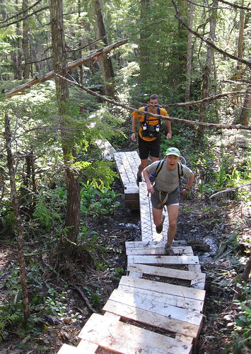
After a 45-minute water taxi trip past dining sea otters and jumping porpoises, the water taxi drops you off at a small rocky promontory redolent of the southern trailhead of the WCT. Then you go up, up, up, the trail, for 9K of inland hiking. This is the steepest and newest section of the trail. Fresh new boardwalks carry you over beautiful pocket marshes. There are many development on the trail, although once a summer of hiking boots churns up this section, it will likely become a huge mudbath.
Here be some decent short running spurts once the trail flattens out. The foliage is low-lying, and generally harmless, although all of us emerged with bloodied shins.
Eventually the stunted trees of the bogs give way to huge ancient cedars, salal bushes and salt air that herald the open ocean. You then plunge down to the first beach, the lovely and rocky (but fairly runnable) beach at Skinner Creek. You emerge blinking from the forest, to the beach framed by the Skinner Creek valley forest, and, if the weather is as spectacular as it was on our day, the snow-capped peaks of the Coastal Range, including Mount Waddington in the far distance.
Skinner Creek to Nahwitti River (9k-12k)
This section features a series of short beaches: run to the end of the beach, spot the buoy hanging from a tree, climb up the headland, run ten strides, climb down, enjoy the beach. Due to high cliffs, the beaches are difficult to pass at high tide, and there is a more rough trail running parallel to the beaches.
The Nahwitti River will eventually have a cable car for crossing, but until then, one must ford the river. At low tide, with a gentle current, one can do so up to mid-thigh. Counter-intuitively, the easiest place to do so is not near the sea, but half-way up the beach, above a rocky outcrop that creates a bit of a mini-rapid. The idiot writer of this write-up tried to ford the river below this point, and soon found himself swimming. Only the camera drowned, accounting for the lack of photos from 12K on.
Nahwitti River to Cape Sutil (12k-17k)
You’ll have some moments of doubt as you clamber along the slippery rocks on the west side of the Nahwitti River to find the trail, starting just past the abandoned cabins which once apparently hosted a Teddy Roosevelt hunting party. After about 10 minutes, you’ll find a grassy outcrop, near which is trail flagging.
Considered by the map to be the most difficult stretch of trail, this section is a series of good mini-runs, rope descents, traverses of pocket beaches, and rope ascents. Many of the trail access points were territorially marked by huge piles of bear scat, although we saw no bears during the whole run (apparently it is rare to miss seeing one on this trail). The Cape Sutil beaches offer pleasing views of headlands, the coastal range, and surf pounding against off-shore rocky shoals. The Cape Sutil headland was the former site of Nahwitti, a fortified aboriginal village. Nahwitti was shelled by the HMS Daphne in 1851 after the inhabitants killed three Hudson Bay Company sailors the previous year.
Cape Sutil to Irony Creek (17k-24k)
A similar series of headlands, short runs, and rocky beaches. The pocket beaches each seemed to serve as killing field for separate marine fauna: on one, mussel shells were piled up; on another, piles of coral. Irony Creek, ironically absent in irony, but named for its rusty colour, is the last water source for a long time, so stock up.
Irony Creek marks the eastern end of the most spectacular sandy beach on the NCT extension: Shuttleworth Bight. Running along the beach, with mountains in the distance, roaring surf, and blue skies: just about perfect. We lunched and swam here for about an hour, joined by Fred from Comox who was taking a break from circumnavigating Vancouver Island in a kayak.
Irony Creek to Laura Creek (24k-35k)
After the paradise of Shuttleworth Bight you return to the forest and haul yourself across the Stranby Creek cable car: rope friction makes this a more exhausting exercise than the well-broken-in cable cars of the WCT. After a brief runnable stretch, one returns to the beach.
This is a cruel stretch. Both the Wall Expedition and the Crerar Expedition flagged during this leg-pounding 11K stretch over a variety of rocky beaches. One day it would be good to add a trail slightly inland to the beaches, in the manner of most of the beaches on the WCT and JDFT, but for now, the steep and rocky beaches are the only route. To add to the cruelty, both of our groups fooled ourselves into thinking that we had hiked about 5K more than we actually had; the realization of our actual location, based upon the western topography of the Nahwitti Cone and two bays, instilled despair.
This stretch nonetheless features weird and wonderful sights: sea stacks, rocky limestone shelves teeming with sea life; concentrations of bald eagles soaring overhead; strange thick carpets of dried sea-grass creating a dreamlike womblike running surface for hundreds of metres. Several trees in the adjacent forest feature huge burrs.
Laura Creek to Nissen Bight (35-43k)
The end of the beaches and return to the forest was a great mercy. This home-stretch is very runnable if there is any power left in your legs, and if a recent rain has not turned it into a soggy swamp. This stretch features several WCT-style stairs, boardwalks, and bridges, as well as traces of old roads left by the Danish settlers during the settlement attempts of the 1910s and 1930s. After passing Laughing Loon Lake, and traversing a highland covered in stunted Seussian pine trees, you descend down to the beautiful sandy expanse of Nissen Bight, the end of the NCT extension, and the start of the original Cape Scott Provincial Park.
Nissen Bight to San Josef Bay trailhead and parking lot (43k-58k)
This should be an easy run: this former settlement road is generally flat and straight and except for the occasional sea of mud, covered in boardwalk and corduroy roads. That being said, the final 15K were psychologically grueling, at first hindered, and then abated, by the kilometer markers (the only kilometer markers on the trail).
Side-trails lead to settler graves, Eric Lake, abandoned settler farming dykes, the Cape Scott Lighthouse, and the stunningly beautiful beaches of Nels Bight, and the double-beach peninsula of Experiment Bight and Guise Bay. These areas of outstanding scenic beauty, with their dense European and aboriginal history, are well-documented elsewhere, and would make themselves a superlative one-day trail run or week-long adventure.
Conclusion
As I write this, two days after the run, I am thoroughly pleased that I ran the North Coast Trail. Had you asked us during the run, the answer may have been different. Again, it is all a matter of managing expectations. It is a very challenging trail run, one that would be very difficult were the weather stormy, as it often is. If you had the luxury, it would be best to give yourself a three-day window on which to run it. Had the rocky beaches and boardwalks been slippery, progress would have been considerably more slow and risky, and possibly have required an emergency overnight stay. The bottom line is that the NCT is a testament to the Trail Society that has been working to create this adventure of great natural beauty for almost a decade.
Photographs
http://flickr.com/photos/8661048@N07/sets/72157605492269631/


Comments
Great Write-up
Awesome Adventure and Awesome Report