According to what I see on the current standings list, nobody has yet done Paton Peak. Given that this is the first year it is an official Bagger Peak I shall lay claim, along with my trail companion, Liza, to being the first official Baggers on record as of July 18, 2010. Of course, the one to get really get some recognition here is Monty Watts for pointing out the fact that Paton exists and is a notable viewpoint at least.
Monty's trailhead description from 2009 is pretty accurate too. We parked at Lynn Headwaters and ran to Rice Lake via the Lynn Headwaters bridge. This put us on the Seymour Valley Trailway for a gentle run of about 9.5km to the turnoff for Paton. There is a green sign on a post at the turning point up a nice looking gravel roadway but sorry I don't remember what it says. Though there is no reference to Paton Peak there I assure you. A sharp left turn on to the rising gravel roadway begins to narrow in a short time. I am guessing that in about 1/2km you reach what I believe to be an unnamed creek: It is not Paton Creek as that is farther along by the Seymour Falls Dam. We first started up the creek not noticing any other trail and spent a good chunk of time exploring that option. The best things to come of that however were awesome huckleberries and quiet place to take a break. The creek got tougher the higher we got and the brush was thick on both sides.
 Liza had a feeling the trail was on the north side of the creek and in the end she turned out to be right. But we only found that out after heading back down and searching carefully. Once we hit the gravel road/trail again, I turned and found the tape marker. We quickly figured out that was the way to go and off we went, up, up, up and more steep up. It's a well marked trail though perhaps not well used and it's also very scenic. Imagine the Grouse Grind with bigger trees, very nice undergrowth and soft trails but climbing several hundred meters up, way up, straight up. The trail begins immediately adjacent to the creek by the way. Do not go onto the creek nor cross it in any way but go right up to it.
Although there was hardly anyone else there, after about an hour we were passed by a hiker who had a GPS and he showed me that we were at the 507m mark and what to expect for terrain ahead. He was on his way to Coliseum for the day. We also saw a couple coming down from the peak and they gave us some pointers for getting there and mentioned to watch out for the junction to the saddle and Coliseum. The junction is only 5 minutes from the top. At that time we didn't know we were going to go back home a different route but their info helped at least a bit in time. If my memory is correct, we hit the top with a great lookout at around 1:30 pm (start time was just after 9:30 am).
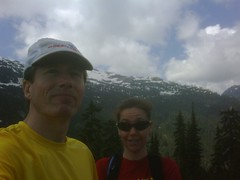
The views are spectacular and it's a nice place to hang out for a while. The breeze was cool but the sun was shining on us and it was a warm day. You look across to the Fannin range and the peaks over there would be easy to point out if you knew them well. And you can see down to the Seymour Reservoir and then behind you to the east side of Coliseum Mountain. In fact Coliseum is right in your face and was heavily covered in snow.
For the return route, we decided in the end to head up toward Coliseum where the next trail junction is at the saddle. The Bagger instructions seem correct that the prominence of Paton Peak is about 90 meters up from the next climbing point. There is a little valley there with a clearly marked trail that soon turns into a ramble through a variety of terrain and flora, eventually coming out beside the sheer rock face of Coliseum. We saw another hiker on the way through that again gave us some pointers.
I was at the saddle on my first and only trip so far to Coliseum around a dozen years ago so I had an idea of what to expect. We had to traverse a bit of scree and snow but it was generally easy to find the trail and easy to get there. A brief stop and chat with another hiker heading down through the Norvan Creek route and we were off to descend into Lynn Headwaters finally. We felt that the choice of going back down from where we came was not a bad idea but since we parked at Lynn Headwaters and we could then do a loop the Norvan route seemed to make sense. And the last hiker we saw agreed it was a more gentle trail as he told us he had done the eastern side as well on a previous hike. And in fact it is a gentler trail, albeit long and there are some steep sections for variety and to hold your attention. I would say it is a 3 to 3.5 km section of trail down to Norvan Falls and it does seem to go on forever when you've already been out there for several hours.
But we did make it down finally, just as I ran out of water. And we made the left turn to head for the parking lot and the relatively short and easy 6.5 km run back to the car. All in all a satisfying day and one more peak for the list. And, an apology to Liza for keeping her out there for almost 9 hours when she asked to do a 4 to 6 hour run, sorry Liza.
And for the Bagger Challenge host, David, I agree that Paton is worthy of being on the list.


Comments
Mount Monty
Yes: Monty should really get credit for putting Paton on the radar screen.
It is a decent adventure in its own right, and not just a hiccup on the way up to Coliseum.