 After finishing Stormy 2 person relay the next adventure was the South Chilcotin Mountains.
The plan was to fly into Lorna Lake back then ride back to Tyaughton lake. I was a bit concerned with the ride as my legs were still sore from Stormy on the Tuesday and only starting to feel normal again on the Wednesday, the plan was book to fly out on the Thursday.
Wednesday night we started to pack our bags making sure we had the extra just incase stuff (head lamps, emergency bivy sack, tools, spare parts, extra clothes and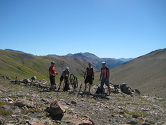 food. The girls were starting to wonder if we were planning on come back or not, but I have had a 9 hour run turning into a 27 hour adventure before. I think they were mostly concerned because they were riding the next day.
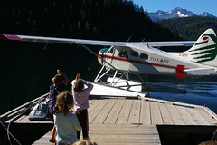
We shuttled a truck down the logging road as to not have to ride an extra 10 km up hill after a 9 hour ride. The plane picked us up at 9:00 am. The plane is a 6 passenger Dehavilland Beaver to carry bikes the back two seats are taken out. The flight is fantastic showing you the route you will be biking out. We flew into Lorna Lake and our route was Lorna pass along Tyaughton creek, up Deer pass, down to Trigger Lake then Hummingbird Lake and then follow Gun creek trail out to truck.
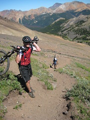 Off the plane, tires back on the bike and ready to ride. We only made it maybe a kilometer before crossing a creek and then having to hike a bike up Lorna pass. There is not much of a trail here and lots of scree and loss gravel. I made it to the top of the pass and said "I would have been here a lot quicker if I was lugging this 30 lbs bike up the mountain". Now the biking began down nice single track. Until Deer pass, at first you could bike up most of it then it just got harder and harder finally you just walking your bike. It is getting close to 1:00 pm, I am hunger and tired are we every stopping for lunch? After a sandwich and pumping water and feel much better and start off on the push up Deer pass. The top of Deer pass (2,331 m) is more fantastic views.
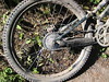
From Deer pass it is pretty much down hill the rest of the way with some small up hills. Every uphill quickly burns the legs and you wonder how long it is going to last. We stop at Hummingbird Lake and enjoy a nice swim and then continue down the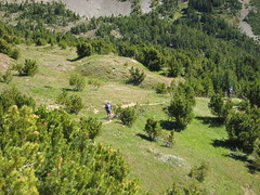 trail. Not long after leaving Hummingbird and enjoying some nice down hill my derailleur catches I slam on the brakes, but it is too late I snapped my derailleur hanger into. Two of the other riders have spares but a derailleur hanger is ever specific to each bike. After many chain brakes and reconnecting we finally set my bike up with one gear. I get granny two (the second lowest gear). This is good for going uphill but doesn't help on the nearly flat or down hill. The good new is I can peddle and it is mostly down hill out. It turns out to be and other 3 ½ hours out.
 Going down the river was fantastic single track trail lots of fun even with one gear, this is the reason we are on bikes. Here I was glad to have a bike and was thinking this is were the pain would really set in on a run. I had a great ride and would recommend the route to any with experience backcountry riding or running. We are already talking about going back again next year maybe even do two float plane drops. More pictures
Summary Data
Total Time (h:m:s)9:12:02 10:27 pace
Moving Time (h:m:s)6:49:22 7:45 pace
Distance (km)52.82
Moving Speed (kph)7.7 avg. 43.1 max.
Elevation Gain (m)+1,628 / -2,674
(Note I managed to hit the stop button on my watch and didn't notice for couple of hours the actual route is probably closer to 60 km).
More info:
Camping at: http://www.tyax.ca/
Flights at: http://www.tyaxair.com/
BC Parks: http://www.env.gov.bc.ca/bcparks/explore/parkpgs/spruce_lk/


Comments
Cool Adventure!