After a bit of back and forth planning chaos and a change in peak choice from Gardner to Fromme, three eager gals set out yesterday afternoon to scale Mount Fromme.
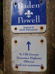
Instigating the whole adventure I ended up in charge of choosing the route and opted to attempt to find the way via the Old Grouse Mountain Highway, an unmaintained trail that starts pretty much in our backyard and heads steeply up the lower part of Fromme Mountain parallel to the east bank of Mosquito Creek.
Years ago, Ean and I had attempted to hike up this trail and ended up bushwhacking a great deal. It starts just east of the Mosquito Creek bridge along the Baden Powell Trail. We were all nicely surprised to find the trail in great shape and well marked with red flagging and headed straight up the side of the mountain. Crossing a few old skid logging roads zig zagging up the slope, we stayed on the smaller, steeper trail and eventually came to an intersection with yellow signs pointing us either to the Kwai Bridge or up the Old Grouse Mountain Highway. Kwai Bridge sounded appealing and we decided on a detour to check in out.
Mosquito Creek is flanked by steep cliffs and nothing like the lower, more sedate part of the river. I have bushwhacked up the west side and was anticipating similar unforgiving terrain, but to our surprise the trail was clearly visible and easy to follow. After about 10min Kwai Bridge appeared in a grove of old cedars and Douglas Firs. It spanned a small gully and consisted of planks nailed to a huge downed tree connecting both sides. At the other end the bridge continued left along the steep gully. Luckily, a steel cable was handily installed at chest height as a "security blanket". Claudia and myself are not fond of heights and really appreciated the railing ;-) Soon our path descended down to Mosquito Creek and we decided to turn around to pick up the Old Grouse Mountain Highway. A lone hiker mentioned that we could also take another smaller trail just east of the Kwai Bridge and we followed his advise. This trail was marked but unnamed (Pat and Claudia both seem to remember seeing a sign calling it "Witches Broom"). Eventually, this trail spat us out at the old, overgrown traverse to the BC Mountaineering Cabin. We veered right towards Mountain Highway, then a quick left steeply up Per Gynt. We crossed Mountain Highway one more time to pick up a trail that cut into the woods just south east of the quarry, skirting the quarry at first, but then gently ascending the south side of Mount Fromme.
I love the North Shore mountains and this hike led us through all the magic of these steep slopes. We heard hooting owls, thumping grouse', chattering squirrels, saw a woodpecker, ate salmonberries and fiddleheads and passed through groves of old cedars and Douglas Firs. The lone hiker near the Kwai Bridge and a couple of friendly Mountain Bikers where the only other people we encountered - who needs the Grind?
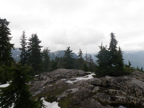
Towards the South Peak snow patches covered most of the blueberry bushes. Post holing through the crunchy snow resulted in soakers and scraped shins. The air was fresh and the skies overcast with some blue patches when we briefly rested at the South Peak - very careful to make sure to stand at the highest point to earn the "bag".
The plan was to hike to the North Peak and then descend towards the Pipeline Bridge and Mountain Highway, but trail finding in the snow was difficult and treacherous and we gave the North Peak a miss when we found markers and faint tracks in the snow leading down the mountain in a favorable direction. The descent was steeper and harder to find than the trail we ascended on. There was lots of blow down and steep snow patches. During most of the downhill we saw the ski hills of Grouse and the wind mill in the distance, but to my surprise, the trail suddenly changed directions and the view opened up towards Thunderbird Ridge. Wrong direction for us...I did not want to end up in the Kennedy Lake area... I contemplated briefly, that we might have to head up again if the trail continued in the wrong direction, but luckily, in an area called Pipeline Pass, we hit a trail intersection with "Erik the Red" trail leading to Thunderbird Ridge and our trail following an ancient pipeline along a rocky trail down to Mountain Highway - just as planned.
Our options here were to go up to Grouse Mountain and take the Skyride back or turn left following the gravel road to Per Gynt and retracing our steps back to the Mosquito Creek Bridge. The sun was out, the views across the Lower Mainland stunning and the spirits were high as we cranked up the speed and fell into a nice trot down Mountain Highway - opting for the self propelled version to get back home. We briefly considered taking the first trail down into the Mosquito Creek canyon, but knowing how inaccessible this area is, we chose the more traveled path. Instead of Witches Broom we found and followed the trailhead to the Old Grouse Mountain Highway ending up at the intersection were earlier in the afternoon we had veered off to follow the Kwai Bridge signs.
This last portion was extremely steep, well marked with a few washouts and blow downs to switch things up. When hitting the old skid roads it would have been easy to take a wrong turn, but we could smell the barn and Mosquito Creek was now roaring not to to far below us.
 Instigating the whole adventure I ended up in charge of choosing the route and opted to attempt to find the way via the Old Grouse Mountain Highway, an unmaintained trail that starts pretty much in our backyard and heads steeply up the lower part of Fromme Mountain parallel to the east bank of Mosquito Creek.
 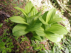 Mosquito Creek is flanked by steep cliffs and nothing like the lower, more sedate part of the river. I have bushwhacked up the west side and was anticipating similar unforgiving terrain, but to our surprise the trail was clearly visible and easy to follow. After about 10min Kwai Bridge appeared in a grove of old cedars and Douglas Firs. It spanned a small gully and consisted of planks nailed to a huge downed tree connecting both sides. At the other end the bridge continued left along the steep gully. Luckily, a steel cable was handily installed at chest height as a "security blanket". Claudia and myself are not fond of heights and really appreciated the railing ;-) Soon our path descended down to Mosquito Creek and we decided to turn around to pick up the Old Grouse Mountain Highway. A lone hiker mentioned that we could also take another smaller trail just east of the Kwai Bridge and we followed his advise. This trail was marked but unnamed (Pat and Claudia both seem to remember seeing a sign calling it "Witches Broom"). Eventually, this trail spat us out at the old, overgrown traverse to the BC Mountaineering Cabin. We veered right towards Mountain Highway, then a quick left steeply up Per Gynt. We crossed Mountain Highway one more time to pick up a trail that cut into the woods just south east of the quarry, skirting the quarry at first, but then gently ascending the south side of Mount Fromme.
 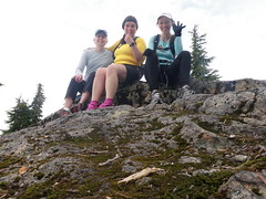 I love the North Shore mountains and this hike led us through all the magic of these steep slopes. We heard hooting owls, thumping grouse', chattering squirrels, saw a woodpecker, ate salmonberries and fiddleheads and passed through groves of old cedars and Douglas Firs. The lone hiker near the Kwai Bridge and a couple of friendly Mountain Bikers where the only other people we encountered - who needs the Grind?
 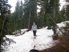 The plan was to hike to the North Peak and then descend towards the Pipeline Bridge and Mountain Highway, but trail finding in the snow was difficult and treacherous and we gave the North Peak a miss when we found markers and faint tracks in the snow leading down the mountain in a favorable direction. The descent was steeper and harder to find than the trail we ascended on. There was lots of blow down and steep snow patches. During most of the downhill we saw the ski hills of Grouse and the wind mill in the distance, but to my surprise, the trail suddenly changed directions and the view opened up towards Thunderbird Ridge. Wrong direction for us...I did not want to end up in the Kennedy Lake area... I contemplated briefly, that we might have to head up again if the trail continued in the wrong direction, but luckily, in an area called Pipeline Pass, we hit a trail intersection with "Erik the Red" trail leading to Thunderbird Ridge and our trail following an ancient pipeline along a rocky trail down to Mountain Highway - just as planned.


