The Bagging of Runners Peak
 Sunday 2 August 2009... a date that will go down in the record books for my buddy Rick and me.
It started innocently enough. With just under a week to go before the STORMY ultras, we thought we'd get in a final shakedown run and bag a peak or two for credit in the 2009 Bagger Challenge.
Rick came by to pick me up at 8:30. As I debated whether to go with one handheld or my Nathan bra-pack, we sketched out a 2 hour itinerary on Mount Seymour. The skies were cloudless. It had been a week of record-breaking high temperatures, but the forecast for the day was high 20C degrees... pleasant in comparison. How to maximize the number of peaks we could bag in a 2-3 hour run? I opted for the hydration pack, stuffed a couple of granola bars and a gel in with my whistle and a vest and off we went.
 Some history: About 5 years ago, it came to be known that the Indian Arm Trail had never been bagged by a runner (e.g. run from start to finish.) At the time, Rick and I were on a rampage of bagging some of the longer hikes in the lower mainland such as Lynn Lake and Colosseum and being first baggers of the Indian Arm Trail had appeal. One similarly fine Sunday morning in August, Rick, Dommer and I ran to the back of Mount Seymour to scout how "runnable" the Indian Arm Trail was. After about 250m on the trail, we concluded that it was not "runnable" at all and gave up. (Note: Murray Comley since fast-packed the thing in 2 days and almost got his ass kicked.)
 Some geography: there is a very popular hiking trail that goes from the Mount Seymour parking area to Mount Seymour via Mystery Peak, First Pump and Second Pump. Total return distance is about 10K. Just beyond Mount Seymour is Runner Peak and then Mount Elsay. From Seymour you can almost touch Runner Peak.
As runners, we figured it was appropriate to bag Runner Peak... and so it became our destination as we jogged out of the parking lot.
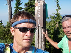
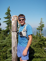
 Now, Rick and I don't take the Bagger Challenge lightly. Rick was careful to document our route on his GPS and I took photos with my new bombproof Olympus camera at the summit marker of each peak we bagged. Since Rick had programmed in the coordinates of several geocaches, we also shook a few bushes and turned over a few stones en route. By 10:30, we arrived at the summit of Mount Seymour.
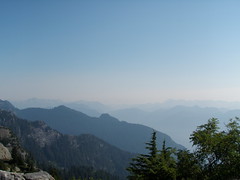
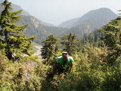
The views were breathtaking. You could see the entire lower mainland of BC. Towards Whistler, the sky was hazy from forest fires. Someone with a good arm could almost throw a rock and hit the summit of Runner Peak and Mount Elsay wasn't far beyond. As we left the main trail, there was talk of bagging them both.
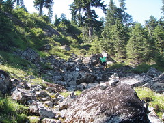
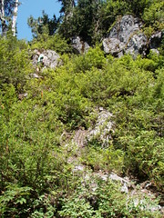 Literally and figuratively, things went downhill from there. The trail was more of a gopher path that dropped precipitously down the side of the mountain. While there was an occasional bit of surveyor tape on the ground or a stone marker, they were very hard to spot. We spent a good bit of time route finding.
We passed though bugland as quickly as possible, but still our noses, ears and eyes were quickly filled with no-see-ums and mosquitoes... not a good place to break a leg! The trail briefly contoured Mount Seymour, then dove down again, eventually bottoming out on a snowfield between Seymour and Runner peaks before climbing steeply back up again.
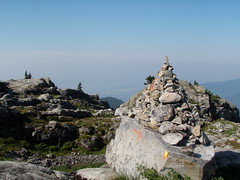
Eventually, we concluded that there was no trail to the top of Runner Peak and that we'd have to bushwack. What were we expecting? There was no trail on our map or the GPS. Our run was now well into its 3rd hour and we were cutting trail.
 Needless to say, our slog up the peak was slow and more than a tad treacherous. We crawled on all fours and pulled ourselves up the side of the spire by holding onto the roots of bushes. But we made it. Then discovered that Runner Peak was made up of several peaks and the one we were on appeared to be the lowest of the bunch.
Neither Rick nor I wanted to go down what we just climbed up, so we went down a saddle and climbed the next peak. It was rough going, to say the least. You sure didn't want to fall up there. No place to land a helicopter. It would take a coon's age to haul someone out if Search and Rescue needed to be called-in.
After achieving our goal, we ventured down a skree slope. It eventually became a steep field of prickle bushes that narrowed into the void. Carefully holding onto roots, we went as far down as we could before the slope became so steep we couldn't go any farther without falling. Bad plan. We bushwacked back up and tried another slope. Equally bad plan. Water, food and time running out, we opted to exit the way we came up. Good plan, though bad for the ego and for our battered and bloodied legs.
 The gopher trail looked like a super highway in comparison to what we'd come from, but was not any easier to follow on the way back. Rick followed a piece of tape. It had probably fallen off a bush and been carried down the slope in a rain storm. Needless to say, it was a "falsie" and we almost got our asses kicked yet again. Now 5 hours into it, we were beginning to think we might not make it home for dinner. It was way hotter than the weatherperson on the radio said it would be this fine afternoon. I began to wonder whether I'd be drinking a cool beer or my own pee first.
Back at the snowfield, Rick stuffed his bottles with snow as I looked for runoff to fill my pack with. I could hear a waterfall in the distance, but couldn't get at the water under the surface. I imagined cold beer waiting for us in Rick's car... but I didn't pack any, so there would be no reward at the end of the "run". We started a very long, steep climb back to Mount Seymour.
By the time we reached Rick's car, we'd been on the trail for about 8 hours. We had no water left. The concession at the parking lot was closed and the vending machine out of order. Damn! 'Made it to the Safeway before either of us passed out... that ice-cold coke tasted a lot better than the alternative that had crossed my mind only a short time ago, thank you.
So, for those of you hoping to add Runner Peak to your baggage list, take heed... and be sure to bring a few pals and some climbing rope!
Photos of the day are here.