Event Home | Registration | Agenda | Course | Results
Backgrounder | Thanks | FAQ's | Contact
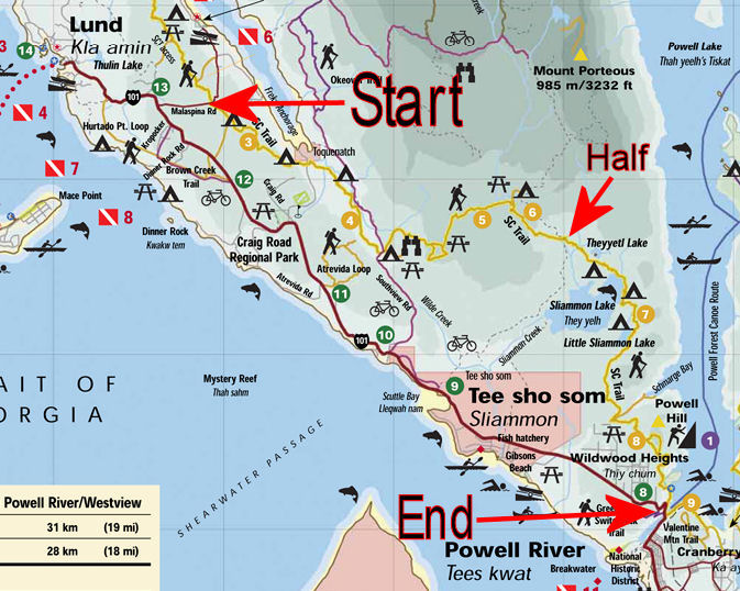
Please print out this course description (scroll down for a printer-friendly version) and bring it with you in a plastic baggie to the start. Here is a rough map of the course with the start of the Full and Half Shuffle as well as the Finish indicated. Here is a profile of the run course on Strava.
Total distance from Malaspina Road to the Shingle Mill 29 km.
Hiking time about 6 to 8 hours, running time about 4 to 6 hours, new astounding record just under 3 hours
Note: Km mentioend refer to the total km of the STC from the northern end at Sarah Point
Route Description – Thunder Ridge: Just past the S-curve of Malaspina Road (Km 21.3 of the SCT) a wide pullout signals the trailhead and the starting point of the Marathon Shuffle along Section Two of the Sunshine Coast Trail.
Follow the clearly marked Thunder Ridge section of the Sunshine Coast Trail, paralleling the road for a short distance. Within 15 minutes, after you pass three big old growth firs along the trail, you reach Fern Creek Bridge, a picnic table and a campsite. Next, the trail runs parallel to a narrow logging spur for about 100 m, which you then cross. On the other side of the spur, just before you start the steep ascent of the trail, an old skid road, you will notice a huge historic steel drum with cogs that probably came off a steam donkey and was left behind when the logging show pulled out early last century. A 15-minute climb will take you to Jay's Junction (23.5 km) where you must make absolutely sure to turn off to the left and begin your descent. Soon a young forest opens onto Okeover Inlet. The trail leaves the maturing forest you have come through and merges onto a logging spur. After turning right on this spur for roughly 50 m, you must then leave it again and turn down to the left, past the twin old growth firs. Keep a close eye on the markers and the additional flags as you keep dropping through the cutblock and across the end of another spur, and a couple of minutes later back into the timber where the trail then crosses Plummer Creek Road (25.2 km).
Route Description – Toquenatch: Step across this gravel road, and drop down 200 m onto the Toquenatch Trail section, which turns into a moss-covered old logging railroad grade among a stand of substantial second growth fir. Turn right (east) on this flat grade. Within minutes you cross Plummer Creek and pass a campsite with outhouse built by the Powell River Rotary Club in 1999.
Stay on the mossy railroad bed. The trail follows the rim of Toquenatch Creek and reaches Toquenatch Falls, where a bridge, rebuilt by the Bloody Old Men’s Brigade (BOMB) Squad, provides an emergency access to Southview Road.
Don’t cross this footbridge (26.7 km). Toquenatch Trail (and the Shuffle route) continues upstream on the west side of the creek. More mossy old railroad grades invite a faster pace. Then you enter a cottonwood plantation. A touch wider riparian zone beside the creek would have allowed the trail to stay inside the canopy instead of being forced out into the recent clearcut. Maintaining a trail out in the open is much more labour intensive and requires continuous attention to keep the brambles and other shrubbery at bay. I can’t remember how many times we have weed-whacked this section since it was harvested about eight years ago. Once the trail re-enters the forest it runs parallel to the logging road built to harvest this area.
Some 200 metres along the edge of the forest and the spur you reach a trail junction. You must turn left staying in the timber, and not go out onto the logging road. The Shuffle route follows the creek upstream, and then crosses it on a new footbridge. Just upstream, there is a beaver dam, and you might be privileged to hear the powerful slap of a tail. Next you will pass the Toquenatch Fir (28.5 km), a giant of memorable girth—eight feet in diameter at breast height (dbh) — surprises you by its sudden appearance. Its estimated age is around 1,000 years. You are now near the end of Toquenatch Trail. A number of boardwalks later you emerge onto Southview Road (28.8 km) about 3.5 kilometres from the pavement of the Lund highway. Turn left on the gravel road and pass over a bridge. At once the road forks. You will find one of the support stations here, and an opportunity to have some refreshments. (There is an outhouse at Homestead Forestry Campsite some 50 metres farther south of this junction.) You will notice the continuation of the Shuffle route (Marathon Trail section) heading uphill on the left (north) side of the rushing Upper Toquenatch Creek (28.9 km).
Route Description – Marathon: Vanilla leaf and chanterelles grow along the mossy trail that winds uphill paralleling the creek. For the first few hundred metres you can see the effects of an inadequate riparian zone on the right, and a clearcut beyond the rushing waters. Uprooted, wind-thrown trees are strewn like toothpicks into the creek. PRPAWS alerted the BCFS by prior to the logging that this would happen. We deemed the buffer inadequate. The contractor ignored even these boundaries and over-cut right down into the gully. These environmentally unfriendly practices occur less frequently now, but are not entirely a thing of the past.
After 15 minutes of hiking through the 80-year-old fir and cedar forest you reach a fork that is easy to miss, as the Sunshine Coast Trail leaves the rim and dips down into the ravine, while the start of the Trinket Trail would take you uphill. You must drop down into the gully and cross the creek via a small footbridge (29.6 km). Watch for the beautiful but poisonous amanitas mascarias, their smooth orange or scarlet heads sprinkled with white flakes. The now gentle grade continues, heading up through salal. The trees are much smaller here. The soil is rocky, and underneath the moss and salal, there is evidence of earlier logging practices: slash burning that devoured much of the duff. Soon the character of the forest changes again. The size of the firs is still the same, but they are much farther apart, though the canopy is unbroken. This is an example of commercial thinning, a more recent, but relatively rare logging prescription. It is an addition to the ministry of forests’ arsenal of tools that is welcomed by the recreational community. The trail makes a little jog (turn right, then left 10 m later) as it crosses a wood road and then carries on back on the trail, heading gently uphill through the open forest.
Soon you come into a bowl where the trees are closer together again and more substantial as there is better soil. You reach a junction with another end of the Trinket Trail to the left, and a trail out to Chocolate Lilly Bluff to the right. You must not turn either left or right, but carry on straight through and uphill. In the spring orchids called lady slippers (calypso bulbosa) grow nearby. After a few switchbacks the trail meanders onto a sub-ridge. Here it meets the old Marathon Trail ascending steeply from below to the right. Make a left turn and follow the ridge to the top and out into a vibrant plantation (31.0 km). About 100 metres after the path levels out you come to 54” Junction (31.2 km) to Gibraltar Bluff.
Here a left turn takes the hiker/runner through the vast fir and cedar plantation via a deactivated but hiker-friendly logging spur. This shortcut crosses a creek and meets a logging road (Branch 10). Turn right for 100 metres and on the crest look for the Sunshine Coast Trail crossing the road. To the left the Shuffle route continues to Rieveley’s Pond with the new Shelter complete with sleeping loft, an outhouse and a swimming dock. (A turn to the right off the logging road onto the trail the loop would curl back toward Gentle David, Gibraltar Bluff and back to 54" Junction in a clockwise fashion.)
(If you are more inclined toward smelling the roses rather than making time you have the option to make a right turn at 54” Junction. This part of the loop is more scenic and longer. First it takes you back into mature forest and then out to panoramic views at Gibraltar Bluff (31.6km). Below you will see the Toquenatch Valley, Okeover Inlet, past which you have traveled, and the lowlands toward Powell River, with the Strait of Georgia and various islands in the distance. Next pass by “John’s Tea House” (31.9 km) over the headwaters of Wilde Creek, and on to the rocky outcropping known as Gentle David, complete with picnic table. Soon the trail comes back out onto the eastern section of the clearcut. After a couple of minutes of traveling through the plantation, the trail emerges onto a logging road (32.5 km). Across the road the SCT continues toward Rieveley’s Pond, Appleton Canyon and Powell Lake. In 1995 Powell River Parks and Wilderness (PRPAWS) lobbied unsuccessfully to have a corridor of standing trees left alongside the trail, rather than having everything clearcut. The area was restocked post harvest and a canopy is finally beginning to form again.)
15 minutes through the timber will take you to Rieveley’s Pond (34.3 km). There is an outhouse here, a rustic campsite, as well as a swimming platform that juts out into this warm pond. Bird and amphibian life is very active in this idyllic spot, where PRPAWS is planning to build a shelter during its current five-year plan. Continue for another half hour toward the Appleton Creek Recreation Site (35.5 km). As you approach Appleton Creek from the north, the rushing sounds will draw you into its mesmerizing rhythm. The pounding of the turbulent waters is never too far.
At a T-junction of the trail, directly above the creek bank, a wooden sign points back up the Marathon Trail over which you have just traveled, advising that Rieveley’s Pond is an hour away. Follow the SCT southward and downstream. (A left turn would take you up a 100-metre long side spur to a picnic table overlooking a swirling swimming hole. This spot lends itself well to a symphonic lunch and, in the summer, to a refreshing swim.)
Route Description – Appleton Canyon:
At the T-junction overlooking the creek below, turn right and follow the Sunshine Coast Trail downstream to a newly refurbished BOMB Squad bridge that takes you safely across to the other side. A sign declares that you have arrived at the Appleton Forestry Recreation site. It signifies the beginning of the Appleton Canyon Trail. This small flood plain is home to a handful of ancient huge Douglas firs that tower over two picnic tables.
The Appleton Canyon section of the SCT slants up onto the rim beyond the campsite. At the top the trail branches, the left branch would take you 300 metres up along the ridge toward an outhouse, while you must make a right turn following the creek downstream. You come to a high spot overlooking the big bend where unseen to the casual eye the creek turns abruptly. From a certain vantage point two sections of the creek are visible—apparently running in opposite directions—and providing a puzzling illusion. The trail keeps dropping along a side hill, and if you look below it you’ll see more large giants, one huge five footer leaning at a precarious angle, its lofty top attempting to grow vertically again.
The path continues downhill and soon levels out on another flats (36.2km). Here, during low water conditions, you can cross to the other side and explore what may eventually become part of a loop returning downstream on the west bank.
At Gorge Falls (36.3 km), you can get down to the creek on a spur and have a swim in the pool, or even a skull-numbing shower underneath the tumbling sheet of water. Though the vegetation is generally small second growth fir, you will see some old growth growing on the slopes down toward the creek.
Next, beyond another flat, a short spur will take you down to a pool at the bottom of Sylph Falls. A few minutes farther the trail dips down onto yet another flat where you can get right next to the creek.
The trail swerves away again temporarily, and minutes later you approach the edge of the canyon where a short but steep side spur will allow you a look at waterfalls and pools directly below you. This is the waterfall that prevents any salmon from getting farther upstream. Three hundred metres below this point you emerge onto the back of a gravel pit that serves as parking lot for people who do day hikes, six kilometres up from the Lund Highway. Exit the gravel pit onto Tomkinson Road (Wilde Road) and find the trailhead of the Sliammon Lakes section (37.7 km) across from there.
Half Shuffle Start 10:00 am at beginning of Sliammon Lakes section
Route Description – Sliammon Lakes: This trail section begins with a few steps down a bank and a bridge across a small creek (37.7 km). It continues on the other side following the creek downstream, then veering off to the East. Within minutes of starting you come to an even smaller creek, which you cross over on Troll Bridge. A large yew tree grows along the bank just a few paces back. A diminutive pool invites the weary traveler to a luxurious bath. The trail continues and soon reaches a gully (38.4 km). There it crosses a seasonal stream with a large, hollow red cedar, then winds its way up and out of the ravine, which is sprinkled with other large old growth cedars and firs.
The terrain becomes rocky and tilts toward Thethyeth Lake (Upper Sliammon Lake 38.8 km) with Bogus Mountain rising roundly beyond this calm lake. The trail cuts away from the lake through a young forest with its solid understory of salal. Once more, now over moss-covered bluffs, it returns to a viewpoint (39.1 km) above Thethyeth with glimpses of the Bunster Foothills and Mount Porteous to the north. A bench here and at the next opening invite the traveler to take a water break and photo op.
A few steps farther along you reach a bare promontory (Kayach Bluff 39.2 km) that affords a grand view of (Big) Sliammon Lake and the terrain that you will travel over along its shore and the shallow pass to the southeast. When this section of the Sunshine Coast Trail had its grand opening in 1993, Elizabeth Harry, a Sliammon elder conducted a traditional blessing ceremony in the Sliammon Coast Salish language. More than 100 people witnessed it. With drum and song, she sent the blessing out to the four directions.
From Kayatch Bluff a gentle and safe reroute drops down to Sliammon Lake at the former shakebolt cutters’ camp near the mouth of tiny Kokanee Creek (40.0 km). Some fish enhancement took place here in the 1980s. There still is a big wooden trough that had been used to rear the kokanee, a landlocked variety of salmon. Rough campsites are nestled among the trees and a swimming spot complete with bench is located at the lake.
The trail continues eastward from here skirting the lakeshore. At Canoe Bay (40.7 km) there is good swimming and picnicking. Two hundred metres farther along you come to an overgrown branch that would lead you down to the right to the Cadets’ Campsite at the edge of the lake. It is an undeveloped site with a few tenting areas cleared out of the ubiquitous salal. The Shuffle route continues south following the shore until it reaches a stream. Here it swings uphill and passes an outhouse at (41.2 km) and then the edge of Dogleg Pond, a favourite of waterfowl. The trail climbs onto an outcropping of rock and winds toward Little Sliammon Lake. Caution: There, in a rocky cleft, a 100-metre-long side spur (42.5 km) off to the right would take you out to a popular swimming and diving spot, while you must stay left to carry on along the main trail. You climb out of the cleft and onto high bluffs overlooking the lake with patches of blue violets growing on the rocky ledges. The route follows the eastern shore to a new shelter named Shangri-La (43.1 km) with picnic table, campsite, outhouse and swimming dock. A short boardwalk juts into the lake from where you might spot a pair of resident loons, or be tempted to go for a swim in the summer time.
A new cutblock (2007) caused the relocation of the trail in this area. It is now part of a woodlot that was awarded to Sliammon First Nation. A SFN donation helped defray costs incurred by the BOMB Squad and PRPAWS in the relocation of the trail and the building of a wonderful new recreation site. The new reroute stays in the riparian zone on the south shore of the lake, then follows an ephemeral creek that feeds into the lake from the south.
As the trail climbs away from the lake you will pass two massive, nearly 1,000-year-old Douglas firs standing side by side (43.7 km). A handful of other old growth veterans stand near the edge of the cutblock. The trail crosses the logging spur and climbs for a few minutes. Soon the trail crests and descends toward Wildwood over mossy outcroppings and through second growth. Salal and Oregon grape cover the forest floor. At 44.9 km the trail emerges onto a system of old logging spurs that leads out to the end of Sutherland Street (45.6 km) in Wildwood, where you will also find the beginning of Scout Mountain Trail (Powell Hill on nautical charts).
Trail Description – Scout Mountain: Be careful at this junction. Don’t take a right turn, which would take you out to the end of Sutherland Avenue and on into Wildwood. Make a left turn (east) toward Three Mile Bay. That old woodroad quickly splits with a right and a left branch. Within 30 metres on the left branch the trail turns right and crosses over the right branch. Carry on straight straight across in a southerly direction toward Scout Mountain. This area is a labyrinth of old wood roads and paths so pay close attention to the multitude of orange markers that have been installed recently to take the guess work out of following the route.
Keep heading south, then east and ignore any of the side trails here and there. Within a couple of minutes the wood road (trail) is joined by another coming up from the left. There is a jog in the route, which now begins to head uphill, still in an easterly direction. Soon you will reach the end of the wood road where the hiking trail proper begins (46.5 km).
About 20 minutes after you started, you will come out on top of the first view bluff (46.8 km). If you look back toward the north you will see the foothills of the Bunsters through which the Sliammon Lakes, Appleton and Marathon Trails wind their way. One large rocky outcropping jutting out into the northwestern horizon is Gibraltar Bluffs, on a loop of the Marathon Trail. Even farther in the distance you will see the low humpback Gwendoline Hills over which the northernmost sections of the Sunshine Coast Trail open up toward Land's End at Sarah Point, the gateway to Desolation Sound Marine Park.
As you move from bluff to bluff your views keep changing and turning farther and farther west, then south. When you reach a large cairn just back of where the trail starts heading down toward Powell Lake, you will notice the summit of Scout Mountain toward the east. Ignore the Summit Loop, which is somewhat longer and higher. You have to keep right on the direct main route that runs along the edge of Scout Mountain on rocky outcroppings. Enough soil has gathered over the ages to give chocolate lilies a foothold. First you pass Choir Bluffs. Here, in 1994, during International Choral Kathaumixw festival four choirs performed songs for the hikers who had brought them onto the mountain, and for the appreciative audience that assembled below in Sunset Park. At the end of the performance hundreds gathered in the park below and enjoyed a salmon barbecue, and each other's company.
Out in the open you'll come upon a park bench, which was erected by the municipality a couple of decades ago (47.9 km). This high vantage point is a good place to take a breath and to enjoy the panorama one more time. You can see the route the trail takes through a logged off area that will become a subdivision. The owner has recognized the trail as a resource, and we will have continued access through the housing development down toward the marina, and the narrows of Powell River. You are a mere 2 km from the finish line.
The route starts to drop steadily across open bluffs. Be careful as you descend over the exposed bluffs down onto the end of the logging road built to prepare the land for the new subdivision, Powell Lake Estates.
Below the steep bluffs you come upon the Wildwood pump house service road (49.2 km), which you must cross. To the left it runs straight down to the pump in the lake, and to the right, straight up to the huge water tank sitting up on Chilco Avenue. Do not turn down to the lake here but take the road curving southward up into a small saddle and a treed rocky outcropping that extends down to the lake. The road you are on levels out in this saddle. A gate restricts vehicular access to this area at this time. You will find the continuation of the trail proper as it descends through the narrow fringe of trees on your left, down toward the lake, hugging the rocky outcropping on your left. Within a few steps this section of the trail right of way passes directly below vertical cliffs. The climbing routes of "Higgyland" are described in detail in a new book by Chris Armstrong entitled “The Climber's Guide to Powell River”.
The trail drops down toward the lake, where you emerge out of the woods. These are your last steps. The trail, now a dirt road, turns right toward a large graveled parking lot – and the finish line. Make sure to sign out when you arrive, and confirm your time. Then take in some refreshments at the Shingle Mill, and tell some tall tales. You have survived the Marathon Shuffle. The fundraiser T-shirts will also be available at the pub. All funds raised from the Marathon Shuffle Shirts, and a 50/50 draw will go toward replacing aging tools, and improvements along the Sunshine Coast Trail. We are following our plan of building more shelters, benches, picnic tables and toilets, and truly appreciate your support. PRPAWS, Box 345, Powell River, BC, V8A 5C2. Tax receipts will be issued for any donations $20.00 or greater. Thank you very much. We hope you will enjoy the trail in good spirits and good health.


