 Sunday 2 August 2009... a date that will go down in the record books for my buddy Rick and me.
It started innocently enough. With just under a week to go before the STORMY ultras, we thought we'd get in a final shakedown run and bag a peak or two for credit in the 2009 Bagger Challenge.
Rick came by to pick me up at 8:30. As I debated whether to go with one handheld or my Nathan bra-pack, we sketched out a 2 hour itinerary on Mount Seymour. The skies were cloudless. It had been a week of record-breaking high temperatures, but the forecast for the day was high 20C degrees... pleasant in comparison. How to maximize the number of peaks we could bag in a 2-3 hour run? I opted for the hydration pack, stuffed a couple of granola bars and a gel in with my whistle and a vest and off we went.
 Some history: About 5 years ago, it came to be known that the Indian Arm Trail had never been bagged by a runner (e.g. run from start to finish.) At the time, Rick and I were on a rampage of bagging some of the longer hikes in the lower mainland such as Lynn Lake and Colosseum and being first baggers of the Indian Arm Trail had appeal. One similarly fine Sunday morning in August, Rick, Dommer and I ran to the back of Mount Seymour to scout how "runnable" the Indian Arm Trail was. After about 250m on the trail, we concluded that it was not "runnable" at all and gave up. (Note: Murray Comley since fast-packed the thing in 2 days and almost got his ass kicked.)
 Some geography: there is a very popular hiking trail that goes from the Mount Seymour parking area to Mount Seymour via Mystery Peak, First Pump and Second Pump. Total return distance is about 10K. Just beyond Mount Seymour is Runner Peak and then Mount Elsay. From Seymour you can almost touch Runner Peak.
As runners, we figured it was appropriate to bag Runner Peak... and so it became our destination as we jogged out of the parking lot.
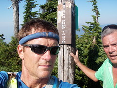
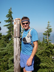
 Now, Rick and I don't take the Bagger Challenge lightly. Rick was careful to document our route on his GPS and I took photos with my new bombproof Olympus camera at the summit marker of each peak we bagged. Since Rick had programmed in the coordinates of several geocaches, we also shook a few bushes and turned over a few stones en route. By 10:30, we arrived at the summit of Mount Seymour.
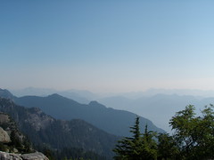
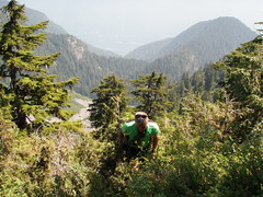
The views were breathtaking. You could see the entire lower mainland of BC. Towards Whistler, the sky was hazy from forest fires. Someone with a good arm could almost throw a rock and hit the summit of Runner Peak and Mount Elsay wasn't far beyond. As we left the main trail, there was talk of bagging them both.
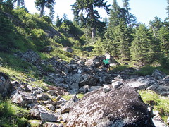
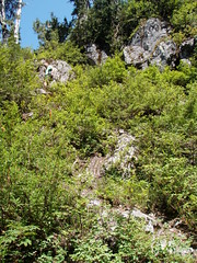 Literally and figuratively, things went downhill from there. The trail was more of a gopher path that dropped precipitously down the side of the mountain. While there was an occasional bit of surveyor tape on the ground or a stone marker, they were very hard to spot. We spent a good bit of time route finding.
We passed though bugland as quickly as possible, but still our noses, ears and eyes were quickly filled with no-see-ums and mosquitoes... not a good place to break a leg! The trail briefly contoured Mount Seymour, then dove down again, eventually bottoming out on a snowfield between Seymour and Runner peaks before climbing steeply back up again.
Eventually, we concluded that there was no trail to the top of Runner Peak and that we'd have to bushwack. What were we expecting? There was no trail on our map or the GPS. Our run was now well into its 3rd hour and we were cutting trail.
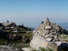
 Needless to say, our slog up the peak was slow and more than a tad treacherous. We crawled on all fours and pulled ourselves up the side of the spire by holding onto the roots of bushes. But we made it. Then discovered that Runner Peak was made up of several peaks and the one we were on appeared to be the lowest of the bunch.
Neither Rick nor I wanted to go down what we just climbed up, so we went down a saddle and climbed the next peak. It was rough going, to say the least. You sure didn't want to fall up there. No place to land a helicopter. It would take a coon's age to haul someone out if Search and Rescue needed to be called-in.
After achieving our goal, we ventured down a skree slope. It eventually became a steep field of prickle bushes that narrowed into the void. Carefully holding onto roots, we went as far down as we could before the slope became so steep we couldn't go any farther without falling. Bad plan. We bushwacked back up and tried another slope. Equally bad plan. Water, food and time running out, we opted to exit the way we came up. Good plan, though bad for the ego and for our battered and bloodied legs.
 The gopher trail looked like a super highway in comparison to what we'd come from, but was not any easier to follow on the way back. Rick followed a piece of tape. It had probably fallen off a bush and been carried down the slope in a rain storm. Needless to say, it was a "falsie" and we almost got our asses kicked yet again. Now 5 hours into it, we were beginning to think we might not make it home for dinner. It was way hotter than the weatherperson on the radio said it would be this fine afternoon. I began to wonder whether I'd be drinking a cool beer or my own pee first.
Back at the snowfield, Rick stuffed his bottles with snow as I looked for runoff to fill my pack with. I could hear a waterfall in the distance, but couldn't get at the water under the surface. I imagined cold beer waiting for us in Rick's car... but I didn't pack any, so there would be no reward at the end of the "run". We started a very long, steep climb back to Mount Seymour.
By the time we reached Rick's car, we'd been on the trail for about 8 hours. We had no water left. The concession at the parking lot was closed and the vending machine out of order. Damn! 'Made it to the Safeway before either of us passed out... that ice-cold coke tasted a lot better than the alternative that had crossed my mind only a short time ago, thank you.
So, for those of you hoping to add Runner Peak to your baggage list, take heed... and be sure to bring a few pals and some climbing rope!
Photos of the day are here.


Comments
Is this why...
...Jackson and RunRik were both dazed and hungry as they staggered around the Seymour peaks?
It's not an easy peak...that's for sure.
Crerar & I scampered to the top of Runner Peak back in the fall of '06.
After we touched the peak of Seymour, we backtracked to a trail in the saddle between 2nd Pump & Seymour. It involved some bushwacking, limb-grabbing, & vertical scrambling before we got to a Haynes-esque boulder field. The final climb was very straight forward & involved a wide slab at one point. We were soaked from the dew on the bushes & the clouds obsured most of the views until we reached the peak.
After tagging the peak, we backtracked to a saddle & took a left turn (eastward) onto another boulder field. This eventually joined the Elsay Lake trail which we used to get us back to Brockton Point. All told, it was no more than 5 hours.
See...next time you need to leave the techno-gadgets behind & bring a mudrunner. ;-)
Mudrunner on Runner Peak...
The things you learn while running at STORMY
So there I was stumbling along the trails back behind Alice Lake at STORMY yesterday with none other than RunRik and the current leader of the Bagger Challenge himself: Ken Legg. (Being more competitive and consequently less inclined to chat, the founder of this prestigious challenge, David Crerar, was somewhere up the trail.)
Oddly enough, the topic of Runner Peak came up. The aforementioned Mr. Legg claimed to have bagged both Runner Peak and Mount Elsay in a 6 hour run. How could this be if it took RunRik and me eight (8) hours to bag Runner Peak alone?
It appears as though experience and research were key to Ken's accomplishments.
You see, we used a topo map and GPS... he asked some folks who had been there. Had we done the same, we would have learned that instead of following the "marked" trail around Runner Peak and bushwacking up a cliff through loose rocks and leg-lacerating bushes from the side facing Mt. Elsay, we should have sauntered up the snowfield and walked right up to the summit!
Sigh. Well, the way I look at it, we had an adventure while earning our baggage credits.
BTW, did you have a rescue helicopter take that shot of you at the summit?
Photo was courtesy of Mr Crerar himself.
Did Ken help you find your way through Stormy? :-p
Whoops!
....sheepish grin....I stand corrected....Mr Crerar jogged my ageing brain & it turns out that you now have clear directions on findimg Elsay.
It turns out that your fancy electronic devices have better memory than a carbon based mudrunner.
actually, that's a photo of
actually, that's a photo of Mudrunner on K2.
Hey there Ean and Rick: Glad
Hey there Ean and Rick:
Glad to know you are back and ready for Stormy!
I too have fond memories of this trail and see you were able to experience some of my fondness as well :) This trail is not to be taken lightly....
Several years ago we too ventured out on the Indian Arm Trail and I was excited at the prospect of being the first woman to complete the trail (silly me). Our push was for "fast packing" in 30 hours as we were training for one of the raid the north adventure races the weekend after kneeknacker in 2004.
Who else was with us but Murray Comley, Dean and Jordy. After much bushwacking, too many peaks to count, along descents I care not to repeat, scratches all over and the incredible "bug layer", we made it down to the end of Indian Arm at 1:00 am, a mere 16 hours after leaving the parking at the top of Seymour. In addition, we also benefited through the use of a few "ropes sections" Don McPhearson had placed for folks like us to use (although he warned us the goats were eating through the ropes and not to rely on them!)
We decided to call it quits at the fire road leading into Squamish at the end of Indian Arm (after a steep descent I was glad not to view in the daylight). As I recall we carried 2 sleeping bags and a bivy sac along with emergency blankets just in case our adventure turned longer than expected. Better to have sleeping bags for warmth rather than the bivy sac as one of our team mates decided to carry instead due to reduced weight in his pack (he was really cold at night).
The night was incredibly beautiful with a full sky of stars everywhere.. this time Murray brought balsamic dip and bagles rather than the one jelly bean he spoke of eating for breakfast, lunch and dinner during his 4 day solo expedition during the year of the floods and the pineapple express... Still have fond memories of this adventure (sort of) and keep looking across the water towards Belcarra as that was the one section we failed to complete (another 11 hours +/- was the estimated additonal time).
In the morning, yours truly managed to talk us into a nice boat ride back to deep cove from a very nice boater anchored near the RVYC dock...
Have a great run at Stormy tomorrow! Hope you enjoyed the read:)
Indian Arm Trail
Thanks for the interesting story, Laddie. Not at all being interested in first bagger opportunities, what jumped out at me was:
To the first point, I thought Murray did it in two (2) days? True, it has been several years since I saw his slide show and time tends to fog the facts. If it did indeed take Murray 4 days to complete the trail from end to end, would that be considered a run or a fast-pack? If the latter, then it would stand to reason that the Indian Arm trail could still be considered fair game as a first bagging opportunity for a runner to complete non-stop.
To the second point, are you still interested in bagging this sucker?