Location:
South Chilcotins - Gold Bridge, BC
This years event will take place during the weekend closest to the first Full moon of August, which happens to be the long weekend this year, so come join us on August 4th, 2012 for an epic adventure.
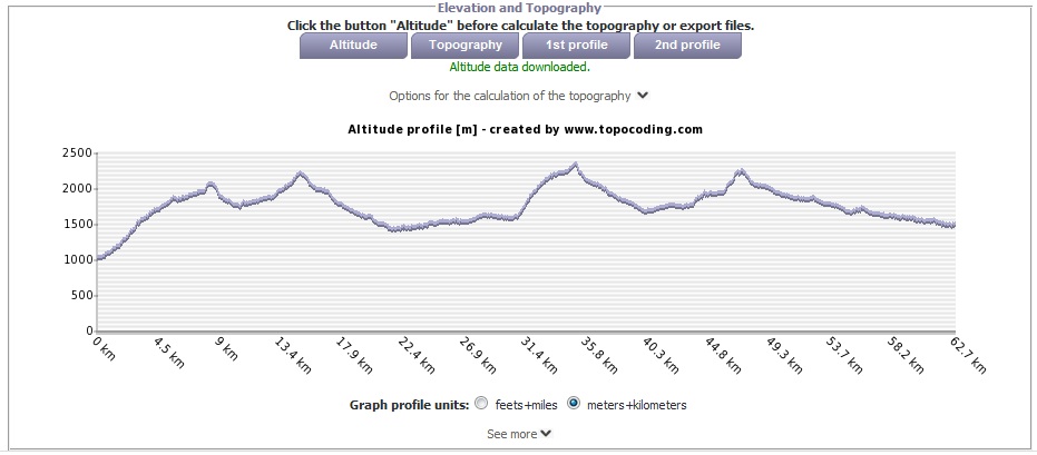
This year, the race will take place in the Spruce Lake Wilderness Area of the Southern Chilcotins. Starting on the Pearson Creek FSR, the course will run over 70km to the Relay Creek FSR, crossing 4 high mountain passes along the way.
It will feature incredible scenery, amazing alpine terrain, beautiful singletrack, and vast wilderness.
Race Format:
The racers will travel in a "peleton" format and "racing" will be decided on with the following criteria, with 2 small prizes up for grabs.
- Sprint Finish Winner: The final 8km will be a "sprint" finish. Placement in the race will be determined here. The sprint starts at a horse ranch shortly after crossing Relay Creek (km 57 on the approximate route map). This final section is almost entirely downhill, and it will be a very fast finish. The final push to the finish line is up a short, but steep & loose section of road.
- King of the Mountains: There will be 4 major mountain passes on the route as part of the over 4000m of vertical to be climbed. Points (5, 3, 1 for 1st, 2nd, 3rd respectively) will be awarded for the first 3 at each of the following:
South Harris Pass (~14km, 2050m)
Windy Pass (~20km, 2200m)
Deer Pass (~40km, 2350m)
the end of Little Paradise Valley (~53km, 2250m)
Approximate route: link
Distance: >70km
Elevation Gain: ~4000m
Start Time: 6am on Saturday August 4th, 2012
Approximate Finish Time: 10pm on Saturday August 4th, 2012
Required Gear: warm & light clothing, emergency blanket, a headlamp, & a bit of real food.
Park Map: link
Background:
A NEW annual Ultramarathon with a twist.
This Ultra will take place during the weekend closest to the first Full moon of every August.
Also, the location is not fixed, and will change every year. The location for the following year, will be announced at the preceding years race. The first year, the race didn't take place at all, although it was supposed to be in the Stein Valley. A snapping MCL & ACL, combined with high quantities of snow in the Western portion of the route resulted in cancellation.
It will feature incredible scenery, amazing alpine terrain, beautiful singletrack, vast wilderness, and ever-lasting memories.
Entry: There is no fee and you don't need to be a member of Club Fat Ass to participate in a Flash event, however whining is not allowed. No registration is required but please indicate your participation via the comment form below. You are responsible for your own well being and safety and should be self sufficient.
PARTICIPATE AT YOUR OWN RISK: YOU ARE WAIVING LEGAL ACTION: By participating in this event you agree to be wholly responsible for your own well-being and agree not to sue anyone associated with this event or Club Fat Ass or any person in relation to this activity. By participating in this event you agree to the terms of the Release of All Claims.


Comments
Next Years Event
http://www.clubfatass.com/events/full-moon-frenzy-2013
Race Report
Write Up
http://www.clubfatass.com/blog/alex/full-moon-frenzy-2012-race-report
More Pictures
Sad I can't be there
Hi Alex,
I would love to be there for the run but I have another commitment that weekend and I am running the Squamish 50 Mile the following weekend. Looking forward to seeing where the Full Moon Frenzy is next year!
interest in full moon frenzy
I just want to check this is a running event as all the photos show mountain bikers?
Will the route be marked, even if small ribbons or is it totally self-navigating?
How many people signed up already?
It'll be a run!
It will be a run. But the only pictures I have of the area are from mountain bike trips.
We won't mark the trail, mostly because we won't have time to go up there and mark it before hand, and then we'd have to take them all down since it's a wilderness area.
We'll also be travelling as a group for the majority of the run. Navigation is fairly easy, unless there's snow and you lose the trail, but even then it's usually easy to find trails up there. I've also biked all of the trails that we'll be going on, so as long as I don't lose my mind, we should be okay.
Also, If you are a mountain biker, bring your bike and stay for the whole weekend to do some riding!
Some Photos to get the stoke flowing
Little Paradise Valley - August 2011
High Trail to Gun Creek - August 2011
High Trail, Upper Tyaughton Creek, Gun Creek - September 2010